Havertown, Pennsylvania
| Havertown, Pennsylvania | |
| Settlement | |
 | |
| Country | United States |
|---|---|
| State | Pennsylvania |
| County | Delaware |
| Township | Haverford |
| Elevation | 276 ft (84.1 m) |
| Coordinates | 39°58′51″N 75°18′31″W / 39.98083°N 75.30861°WCoordinates: 39°58′51″N 75°18′31″W / 39.98083°N 75.30861°W |
| Founded | 1681 |
| Timezone | EST (UTC−5) |
| - summer (DST) | EDT (UTC−4) |
| ZIP Code | 19083 |
| Area code | 610 and 484 |
 Location of Havertown in Pennsylvania  Havertown, Pennsylvania (the US) | |

Havertown is a residential suburban unincorporated community in Haverford Township, Delaware County, Pennsylvania, United States, approximately 9 miles west of the center of Philadelphia. Havertown's ZIP Code is 19083. "Havertown" is a postal address. The name "Havertown" does not appear until the advent of the ZIP Code. Prior to the ZIP Code each community was known by its local name: Brookline, Penfield, Beechwood, Llanerch, Manoa, Oakmont, Coopertown, Ardmore. Under William Penn's land divisions these communities were part of the Welsh Tract and comprised the area known as Harford, a Welsh contraction of Haverford.[1]
History
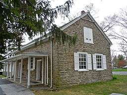
Haverford Township was founded by Welsh Quakers in 1681 on land purchased from William Penn. The settlers named their new home after Haverfordwest, Wales, UK.The township is home to many historic sites. The Grange Estate, entertained the Revolutionary War figures George Washington and General Lafayette. Nitre Hall, along Karakung (Cobb's) Creek, supplied the United States with over 800,000 pounds of gunpowder during the War of 1812. Leedom Hall[2] was the probable home to William Howell the founder of Haverford Mills which date from 1688.[3] Other Havertown sites listed on the National Register of Historic Places include the Federal School and Lawrence Cabin. Coopertown, appears as early as 1848 as the first community and the earliest post office is found at the Spread Eagle Tavern at the junction of the present Eagle and Manoa Roads.
Historic Roads
The Haverford Road is one of the earliest roads laid out by civil ordinance. Dates for its layout and completion vary from 1687 to 1703. Darby Road, known earlier as Coopertown Road dates from 1687. Records show its extension to Radnor the “principal market for corn,” ordered in 1696.[4] Mill Road, at one time called Dickinson Mill Road, may be one of the earliest roads of popular use. Its zig-zag pattern illustrates the indirect path required by horse and cart going up or down hill. Eagle Road which takes its present name from the Spread Eagle Tavern c.1814 led Quaker settlers to the Haverford Meeting House
The Railroads and Planned Communities
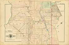
Prior to the First World War Haverford was a township of extensive farms. Property maps in 1862 indicate that the landowners were descendants of the same families that arrived with William Penn: among them, the Lawrences, the Ellis’, the Humphreys and the Lewis’. In 1895 The Philadelphia and West Chester Traction Company begins service between 69th Street and West Chester with a major junction at Llanerch. By 1902 the maps indicate a significant change in land ownership. Most of the old family names no longer appear. In that same year on May 29, the trolley line opened the branch from Llanerch to Ardmore. Llanerch first appears as a small community with numbered streets. Darby Road is called Coopertown Road. A commercial rail line, now removed, served Boyle Fuel, Lobb Lumber and the Swell Bubble Gum factory up until the 1960’s. (See Map)
LLanerch
Llanerch situated at the intersection of West Chester Pike and Darby Road was the first planned community of Haverford Township.[5] Like many other suburban communities Llanerch was the child of the railroad companies. The railroad built houses for commuters and the commuters bought tickets for the rail lines. In 1897 the community was composed of twelve houses and Saint Andrew’s Church. These houses and the church were designed by Philadelphia architect Frank Allison Hayes (1866-1930).https://www.philadelphiabuildings.org/pab/app/ar_display.cfm/22160 Llanerch’s first school followed in 1905. The present school structure, no longer functioning as a school, dates from 1913.
Brookline

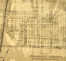
Brookline, while not the first planned community, was the most fully executed. The Mueller Atlas of Delaware County, 1909, shows the initial layout for Brookline.[6] At that time Darby Road between Eagle Road and Llanerch was called Haverford Road. Some construction began around that year, but it was not until after the First World War that the Manor Real Estate Company, a subsidiary of the railroads set out a plan for a housing development that offered every service, amenity and community need: “Brookline Manor.” (See Map) As in the 1909 plan we find an arrangement of regular streets divided by a broad “Boulevard.” The Boulevard intersected at a “T” juncture with the major township thoroughfare, Darby Road. The “Boulevard” would be home to commercial, religious and educational services. At the upper end of the “Boulevard” mercantile stores provided shoe makers, tap rooms, florists, bakery, barbers, a Five and Ten, the Quaker Store, the A&P grocery store and the Boulevard movie theater. (See Image)[7] Along the length of the Boulevard the community found their religious houses of worship: The Methodist Church, Saint Faith Episcopal Church, The Church of the Annunciation of the Blessed Virgin Mary and Temple Lutheran. On Earlington Road, to the side of the Boulevard’s far end The Brookline School (1913) met educational needs.[8]
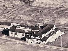
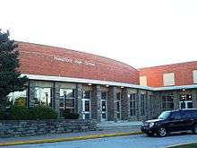
Returning to the intersection of the Boulevard with Darby Road we follow Darby Road west. Just beyond the intersection we find the Brookline Fire Company (1916). The Brookline Library (1938) and the Haverford High School (1923) are on Darby Road just beyond the Brookline Fire Company. In the early days the Brookline County Club and the Brookline airport were situated just behind Haverford High School. (See Image) Returning to the intersection of Brookline Boulevard and Darby Road at the corner of Manoa Road were the Police Station on the west side and Shearer’s greenhouse and nursery on the east side.
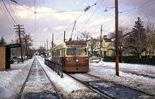
The railroad company attended to their needs to sell tickets as well as to that of Brookline Manor for transportation. The Red Arrow Trolley line #103 ran from Ardmore down Darby Road then on to West Chester Pike to 69th and Market Streets, thus offering commuters quick access to the city.(See Image)[9] The tracks which divided Darby Road were lined with fences of early blooming red roses. A bus line ran from Ardmore to 69th and Market by way of Brookline Boulevard and Earlington Road. The junction of the two lines was at the intersection of Darby Road and Brookline Boulevard. At the far end of Brookline Boulevard commuters found the services of the P&W, The Philadelphia and Western high-speed line. An electric train system that even today is one of the most rapid. With trolley lines at one end, the P&W at the other and a bus that ran between the two transportation to Philadelphia could not have been more convenient. The electric trolley lines were shortsightedly dismantled in 1966 in favor of gasoline operated buses.
__________________________________________________________________________________________________________
The Irish in Havertown
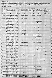
The arrival of the Irish in Haverford Township occurs in three phases: the 19th century mill era, the early 20th century railroad communities and the post World War II suburban housing tracts. Born in Ireland in 1779, Dennis Kelly arrived in Philadelphia in 1806. After several years of manual labor Kelly became the prosperous owner of the complex of mills along Karakung Creek. Kelly and his mills attracted the first Irish Catholics to the otherwise Protestant community. 1860 census records attest to the Irish presence and their occupations in the mills. In 1822, mindful of duty to community and faith, Kelly bought and donated land opposite the Friends’ Meeting House on the hilltop above the mills for the construction of the first Catholic Church. The second and more significant arrival of the Irish comes with the planned community of Brookline c.1925 and portions of Manoa and Oakmont. In 1927 the Church of the Annunciation and The Church of the Sacred Heart together with their schools assured Catholics seeking life in the suburbs of a religious home. The third and largest phase of the Irish move comes with the large brick house tract developments of Beechwood, Chatham Park and Manoa. Today according to the 2000 US Census, Haverford Twp. ranks in the top 60 of census-recognized municipalities nationwide in percentage of population with Irish ancestry.[10]
Bubble Gum
Havertown is the birthplace of Swell Bubble Gum, founded 1947, which closed its doors in late 2004 and was demolished in 2011. In 2013, the site became the home of the new Haverford Area YMCA.[11]
Parks and recreation
Havertown is home to over 30 outdoor parks and playing fields. The town also provides other recreation facilities, including the Haverford Township Free Library, and the Haverford Township Skatium, a multi-use ice rink for Havertown residents.[12]
Haverford Music Festival
The concept for the Haverford Music Festival was introduced by the Haverford Township Civic Council (HTCC),[13] a private, non-profit organization that funds historic, environmental, business, and community initiatives in Haverford Township. Inspired by the Philadelphia Folk Festival, Bethlehem Musikfest and other music festivals in the area,[14] the all-day, family-oriented Haverford Music Festival has taken place annually in the Oakmont Business District of Havertown since 2011. In 2012, the festival attracted more than 15,000 people, who enjoyed over 30 bands on three stages. HTCC benefits from festival proceeds and uses to fund community-based programs within Haverford Township. Proceeds from the 2011 Music Festival were given to the Haverford Partnership for Economic Development (HPED) for Oakmont Business District Beautification.[15]
Education
Havertown is served by the School District of Haverford Township, which has one high school, one middle school, and five elementary schools. A newly refurbished elementary school, Chestnutwold Elementary, re-opened its doors in early September 2008. It replaced Oakmont Elementary, which became home to the district offices. In 2009, Manoa Elementary School moved from Manoa Road to the intersection of Manoa and Eagle Roads, taking part of the field that had been there for many years. The Haverford High School sports teams are called the "Fords," and have a Model T Ford as mascot.
Haverford High School had the honor of being the only high school in the Philadelphia area to host the One Book, One Philadelphia author Julie Otsuka.[16] Otsuka's The Buddha in the Attic is a recent PEN/Faulkner Award winning work of historical fiction and a National Book Award finalist.[17]
Police and fire
The town is protected by the Haverford Township Police Department and five volunteer fire companies that make up the Haverford Township Bureau of Fire:
- Oakmont 38 (http://www.oakmontfire.org), which houses the following apparatus; Engine 38, Squad 38, Ladder 38, and Rescue 38
- Manoa 56 (http://www.manoafire.com), which houses the following apparatus; Engine 56, Squad 56, Rescue 56, Utility 56 and 56-8.
- Brookline 35 (http://www.brooklinefirecompany.org), which houses the following apparatus; Engine 35, Ladder 35, Foam 35, and Spill 35
- Llanerch 34 (http://www.llanerchfire.org), which houses the following apparatus; Engine 34-1 and Engine 34-2, and Tower 34.
- Bon Air 58 (http://www.bonairfire.com), which houses the following apparatus; Pipeline 58, Squad 58, and Rescue 58
- EMS coverage is currently contracted to Narberth Ambulance
Environmental remediation
Havertown has a Superfund site caused by the National Wood Preservers wood treatment facility, which was in operation from 1947 to 1991. The chemical used to treat wood at this site was dumped into the ground.[18] The Environmental Protection Agency began remediating the site in 1976, and they completed construction of the cleanup site on September 16, 2010. The groundwater continues to be extracted and treated on a continuous basis. Although approximately 26,000 people live within a mile of the site, there are no known users of the groundwater within a one-mile radius of the site. The nearby population is on the public water supply.[19]
Notable people
- Howard Benson, two-time Grammy nominated producer
- Leo Burt, anti-war activist, still at-large; on FBI Most Wanted List in connection with 1970 Sterling Hall bombing at University of Wisconsin campus
- Speedy Claxton, former NBA player
- Jerry Crawford, MLB umpire
- Joey Crawford, NBA referee
- Marguerite de Angeli, award-winning children's book author who lived in Manoa in 1930s
- Tim Donaghy, former NBA referee, game fixer
- Kyle Eckel, NFL player, two-time MVP of Army-Navy game
- John Facenda, Philadelphia newscaster and narrator for NFL Films
- Rick Fisher, two-time Tony Award winner for lighting
- Stephen Freind, Republican representative in Pennsylvania General Assembly
- Alex G, singer-songwriter[20]
- Frank Gasparro, Chief Engraver of the US Mint
- Julie Gold, composer
- Brendan Hansen, four-time Olympic medalist
- Joshua Humphreys, shipbuilder
- Ross Katz, film producer
- Billy King, former GM of NBA's Philadelphia 76ers
- John LeClair, played for NHL's Philadelphia Flyers
- Joe Lunardi, ESPN bracketologist
- Glen Macnow, Philadelphia radio personality
- Marcus McElhenney, coxswain, 2008 Beijing Olympics bronze medalist
- Mary Lou Metzger, singer and dancer on Lawrence Welk Show
- Ryan Mulhern, former Washington Capitals hockey player
- David Ricketts, composer, guitarist, producer for A&M Records
- Robin Roberts, Phillies pitcher, Hall of Famer, resided in Manoa
- James Rolfe, Angry Video Game Nerd
- Michael Sembello, composer, guitarist, wrote "Maniac" for Flashdance film soundtrack
- Jean Shiley-Newhouse, 1932 Olympic gold medalist
- Mike Tollin, film producer and director
- Sam Venuto, former running back in National Football League[21]
- Tom Verica, actor
- Mark Yudof, president of University of California
See also
References
- ↑ Browning, Charles Henry. Welsh Settlement of Pennsylvania. P, Charles Henry (1912). Welsh Settlement of Pennsylvania. Philadelphia, Campbell.
- ↑ "Leedom Hall".
- ↑ Ashmead. History of Delaware County. p. 569.
- ↑ Record of the courts of Chester County, Pennsylvania, 1681-1697. p. 399.
- ↑ "LLanerch".
- ↑ "Delaware County Brookline".
- ↑ "Cinema Treasures".
- ↑ "Haverford Township Schools".
- ↑ "Route 103".
- ↑ "Ancestry Search - Genealogy by City - ePodunk.com". www.epodunk.com.
- ↑ Haverford Area YMCA.
- ↑ Skatium
- ↑ Haverford Township Civic Council
- ↑ "iradiophilly - News - Haverford Music Festival Q and A with Tom Kelly, Chairman". iradiophilly.
- ↑ "Blog - Haverford Music Festival". haverfordmusicfestival.org.
- ↑ https://libwww.freelibrary.org/programs/onebook/obop13/index.cfm
- ↑ "The School District of Haverford Township / Overview".
- ↑ "Havertown PCP". Retrieved 24 January 2010.
- ↑ OSRTI, US EPA,. "HAVERTOWN PCP Site Profile". www.epa.gov.
- ↑ DeLuca, Dan (December 7, 2014). "Alex G: One-man band a Philly indie success". The Philadelphia Inquirer. Retrieved July 20, 2015.
- ↑ "Sam Venuto". Pro-Football-Reference.Com. Retrieved October 14, 2012.
External links

Municipalities and communities of Delaware County, Pennsylvania, United States | ||
|---|---|---|
| City | 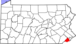 | |
| Boroughs | ||
| Townships | ||
| CDPs | ||
| Unincorporated communities |
| |
| Ghost town | ||
| Footnotes | ‡This populated place also has portions in an adjacent county or counties | |