Borough of Harrogate
| Borough of Harrogate | ||
|---|---|---|
| Borough | ||
| ||
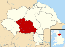 Shown within North Yorkshire | ||
| Sovereign state | United Kingdom | |
| Constituent country | England | |
| Region | Yorkshire and the Humber | |
| Ceremonial county | North Yorkshire | |
| Admin. HQ | Harrogate | |
| Government | ||
| • Type | Harrogate Borough Council | |
| • Leadership: | Leader & Cabinet | |
| • Executive: | Conservative | |
| • MPs: |
Nigel Adams, Andrew Jones, Julian Smith | |
| Area | ||
| • Total | 505 sq mi (1,308 km2) | |
| Area rank | 15th | |
| Population (mid-2017 est.) | ||
| • Total | 160,000 | |
| • Rank | Ranked 118th | |
| • Density | 320/sq mi (120/km2) | |
| Time zone | UTC+0 (Greenwich Mean Time) | |
| • Summer (DST) | UTC+1 (British Summer Time) | |
| ONS code |
36UD (ONS) E07000165 (GSS) | |
| Ethnicity |
96.9% White 1.0% Mixed 0.8% S.Asian 0.8% Chinese or other 0.6% Black[1] | |
| Website | harrogate.gov.uk | |
The Borough of Harrogate is a local government district and borough of North Yorkshire, England. Its population at the census of 2011 was 157,869.[2] Its council is based in the town of Harrogate, but it also includes surrounding towns and villages and almost all of the Nidderdale Area of Outstanding Natural Beauty. It is the most populous district of North Yorkshire. The district is part of the Leeds City Region. It borders the City of Leeds, and the City of Bradford, districts of West Yorkshire.
The district was formed on 1 April 1974, under the Local Government Act 1972, as a merger of the Masham and Wath rural districts, and part of Thirsk Rural District, from the North Riding of Yorkshire, along with the boroughs of Harrogate and the city of Ripon, the Knaresborough urban district, Nidderdale Rural District, Ripon and Pateley Bridge Rural District, part of Wetherby Rural District and part of Wharfedale Rural District, all in the West Riding of Yorkshire.
On 1 April 1996 the parishes of Nether Poppleton, Upper Poppleton, Hessay and Rufforth were transferred from the district to become part of the new York unitary authority. According to the 2001 census these parishes had a population of 5,169.
Politics
Elections to the borough council are held in three out of every four years, with one third of the 54 seats on the council being elected at each election. After being under no overall control from the 2006 election, the Conservative party gained a majority at the 2010 election.
Following the United Kingdom local elections, 2016 and subsequent by-elections,[3] the political composition of Harrogate is as follows: The last composition of the former 54 seat council.
| Year | Conservative | Liberal Democrat | Independent |
|---|---|---|---|
| 2016 | 37 | 10 | 7 |
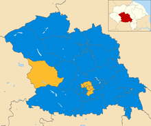
Before boundary change came in.
The current composition of the new 40 seat council from the boundary change is as follows
Local Election 2018.
| Year | Conservative | Liberal Democrat | Independent |
|---|---|---|---|
| 2018 | 31 | 7 | 2 |
The district is divided between three parliamentary constituencies: the whole of Harrogate and Knaresborough, the eastern part of Skipton and Ripon and the north western part of Selby and Ainsty
Towns
By population:
1. Harrogate
2. Ripon (city)
3. Knaresborough
4. Boroughbridge
5. Pateley Bridge
6. Masham
Historical sites
References
- ↑ "Resident Population Estimates by Ethnic Group (Percentages); Mid-2005 Population Estimates". National Statistics Online. Office for National Statistics. Retrieved 2008-03-28.
- ↑ "Non-Metropolitan district population 2011". -Neighbourhood Statistics. Office for National Statistics. Retrieved 15 February 2016.
- ↑ https://localdemocracy.harrogate.gov.uk/summary.asp
