Harling Road railway station
| Harling Road | |
|---|---|
 | |
| Location | |
| Place | East Harling |
| Local authority | Breckland |
| Grid reference | TL978879 |
| Operations | |
| Station code | HRD |
| Managed by | Greater Anglia |
| Number of platforms | 2 |
| DfT category | F2 |
|
Live arrivals/departures, station information and onward connections from National Rail Enquiries | |
| Annual rail passenger usage* | |
| 2012/13 |
|
| 2013/14 |
|
| 2014/15 |
|
| 2015/16 |
|
| 2016/17 |
|
| History | |
| 30 July 1845 | Opened as Harling |
| September 1849 | Renamed Harling Road |
| 28 December 1964 | Closed to freight |
| National Rail – UK railway stations | |
| * Annual estimated passenger usage based on sales of tickets in stated financial year(s) which end or originate at Harling Road from Office of Rail and Road statistics. Methodology may vary year on year. | |
|
| |
Harling Road railway station is on the Breckland line in the east of England, serving the villages of Larling, Roudham and East Harling, Norfolk. The line runs between Cambridge in the west and Norwich in the east.
Harling Road is situated between Thetford and Eccles Road, 101 miles 35 chains (163.2 km) from London Liverpool Street via Ely. The station is managed by Greater Anglia, which also operates most of the services calling at the station. Some East Midlands Trains also stop at Harling Road.
History
The Bill for the Norwich & Brandon Railway (N&BR) received Royal Assent on 10 May 1844. Work started on the line in 1844 and the line and its stations were opened on 30 July 1845. Harling station opened with the line and was situated east of Roudham station and west of Eccles Road station. The line ran from Ely to Trowse, in Norwich. The link into Norwich was delayed due to the need to build a bridge over the River Wensum that kept the river navigable. One month before the N&BR opened a Bill authorising the amalgamation of the Yarmouth & Norwich Railway with the N&BR came into effect and so Harling station became a Norfolk Railway asset.[1]
Description
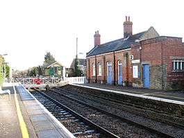
The station is situated approximately 1.5 miles (2.4 km) north-west of East Harling, the village from which it takes its name. A footpath links the station to the village.
Harling Road is a small station and until recently had remained largely outdated. The wooden level crossing gates adjacent to the station used to be opened and closed manually by a signaller in the Harling Road signal box. In December 2012 the signal box was closed and the crossing was renewed with automatic barriers with warning lights.
Passenger facilities are basic, with a car-park and seating in a shelter on the eastbound (Norwich) platform only. There is a bicycle shelter on the westbound (Cambridge) platform. There is no ticket office, and tickets may be bought from the conductor on the train.
Harling Road is located in a rural area, and is ideally placed to provide access to the countryside for those who can not, or do not wish to, make use of a car for transportation. There is easy access to several long-distance footpaths, including the Peddars Way, Angles Way, Icknield Way, Iceni Way and the Hereward Way. There are a number of other opportunities with Knettishall Heath, West Harling Heath and Wayland Wood (where the events that inspired the Babes in the Wood took place) all being within walking distance.
Services
As of December 2015, from Monday to Saturday there are two westbound trains per day, one operated by East Midlands Trains which calls at Thetford and Ely before continuing on to Liverpool Lime Street, the other operated by Greater Anglia which runs to Cambridge, also calling at Thetford, Brandon and Ely.[2]
There are two early-morning eastbound services to Norwich calling at all intermediate stations except Spooner Row, operated by Abellio Greater Anglia.
There is no Sunday service.
References
External links
- Map sources for Harling Road railway station
| Wikimedia Commons has media related to Harling Road railway station. |
- Train times and station information for Harling Road railway station from National Rail
| Preceding station | Following station | |||
|---|---|---|---|---|
| Abellio Greater Anglia | ||||
| East Midlands Trains Limited services | ||||
| Historical railways | ||||
| Roudham Junction Line open, station closed |
Great Eastern Railway Norfolk Railway |
Eccles Road Line and station open | ||