Buckenham railway station
| Buckenham | |
|---|---|
 | |
| Location | |
| Place | Buckenham |
| Local authority | Broadland |
| Grid reference | TG350056 |
| Operations | |
| Station code | BUC |
| Managed by | Greater Anglia |
| Number of platforms | 2 |
| DfT category | F2 |
|
Live arrivals/departures, station information and onward connections from National Rail Enquiries | |
| Annual rail passenger usage* | |
| 2012/13 |
|
| 2013/14 |
|
| 2014/15 |
|
| 2015/16 |
|
| 2016/17 |
|
| History | |
| Original company | Yarmouth and Norwich Railway[1] |
| Pre-grouping | Great Eastern Railway[1] |
| Post-grouping | LNER |
| 1 May 1844 | Opened[1] |
| National Rail – UK railway stations | |
| * Annual estimated passenger usage based on sales of tickets in stated financial year(s) which end or originate at Buckenham from Office of Rail and Road statistics. Methodology may vary year on year. | |
|
| |
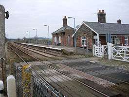
Buckenham railway station is on the Wherry Lines in the east of England, serving the village of Buckenham, Norfolk. It is 7 miles 62 chains (12.5 km) down the line from Norwich on the route to Lowestoft and is situated between Brundall and Cantley. Its three-letter station code is BUC.[2]
The station was opened in 1844. Today it is managed by Greater Anglia. According to usage estimates, Buckenham is one of the least-used stations in the country, registering just 122 passenger entries/exits in 2016/17.[3] A limited number of services stop at the station on weekends, with no services on weekdays.
RSPB Buckenham Marshes is located next to the station, with RSPB Strumpshaw Fen a short walk away. Strumpshaw Hall Steam Museum is also located in the area.
History
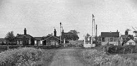
The Bill for the Yarmouth & Norwich Railway (Y&NR) received Royal Assent on 18 June 1842. Work started on the line in April 1843 and it and its stations opened on 1 May 1844. Buckenham is situated east of Brundall and west of Cantley. The Y&NR was the first public railway line in Norfolk. On 30 June 1845 a Bill authorising the amalgamation of the Y&NR with the Norwich & Brandon Railway came into effect and Buckenham station became a Norfolk Railway asset.[1][4]
Two years after the Norfolk Railway took over, Cantley station was closed, meaning Reedham was now the next station after Buckenham.
The Eastern Counties Railway (ECR) and its rival the Eastern Union Railway (EUR) were both sizing up the Norfolk Railway to acquire and expand their networks. The ECR trumped the EUR by taking over the Norfolk Railway, including Buckenham station, on 8 May 1848. Three years later, during January 1851, the ECR reopened Cantley station.
By the 1860s the railways in East Anglia were in financial trouble, and most were leased to the ECR, which wished to amalgamate formally but could not obtain government agreement for this until an Act of Parliament passed on 7 August 1862, when the Great Eastern Railway (GER) was formed by the consolidation. Actually, Buckenham had become a GER station on 1 July 1862 when the GER took over the ECR and the EUR before the Bill received its Royal Assent.[5]
The system settled down for 60 years, apart from the disruption of the First World War. The difficult economic circumstances that existed after the war led the government to pass the Railways Act 1921 which led to the creation of the "Big Four" companies. The GER amalgamated with several companies to form the London and North Eastern Railway (LNER). Buckenham became an LNER station on 1 January 1923.
Upon nationalisation the station became part of the Eastern Region of British Railways
On privatisation the station and its services were transferred to Anglia Railways, which operated it until 2004 when National Express East Anglia won the replacement franchise, operating under the brand name 'one' until 2008. In 2012 Abellio Greater Anglia won the franchise.
Services
As of January 2018 services only stop at the station at weekends, by request only. On Saturdays there is one train to Norwich and one to Lowestoft. On Sundays four trains to Norwich call at the station, with three trains to Great Yarmouth on the Berney Arms branch of the line and one train to Lowestoft.[6]
References
- 1 2 3 4 Butt, R. V. J. (1995). The Directory of Railway Stations: details every public and private passenger station, halt, platform and stopping place, past and present (1st ed.). Sparkford: Patrick Stephens Ltd. p. 47. ISBN 978-1-85260-508-7. OCLC 60251199.
- ↑ OS Explorer Map OL40 - The Broads (Map). Ordnance Survey. 2005. ISBN 0-319-23769-9.
- ↑ 'Estimates of station usage 2011-12', Office of rail regulation (available online). Retrieved 2013-05-30.
- ↑ C.J. Allen
- ↑ CJ Allen - Great Eastern - page46
- ↑ 'Norwich to Great Yarmouth and Lowestoft', Greater Anglia, May 2018.
External links
| Wikimedia Commons has media related to Buckenham railway station. |
- Map sources for Buckenham railway station
- Train times and station information for Buckenham railway station from National Rail
| Preceding station | Following station | |||
|---|---|---|---|---|
| Brundall | Greater Anglia Wherry Lines Weekends only |
Cantley | ||