Eccles Road railway station
| Eccles Road | |
|---|---|
 | |
| Location | |
| Place | Quidenham |
| Local authority | Breckland |
| Grid reference | TM018900 |
| Operations | |
| Station code | ECS |
| Managed by | Greater Anglia |
| Number of platforms | 2 |
| DfT category | F2 |
|
Live arrivals/departures, station information and onward connections from National Rail Enquiries | |
| Annual rail passenger usage* | |
| 2012/13 |
|
| 2013/14 |
|
| 2014/15 |
|
| 2015/16 |
|
| 2016/17 |
|
| History | |
| 30 July 1845 | Opened |
| 18 April 1966 | Closed to freight |
| National Rail – UK railway stations | |
| * Annual estimated passenger usage based on sales of tickets in stated financial year(s) which end or originate at Eccles Road from Office of Rail and Road statistics. Methodology may vary year on year. | |
|
| |
Eccles Road railway station is on the Breckland line in the east of England, serving the villages of Eccles, Quidenham and Wilby in Norfolk. The line runs between Cambridge in the west and Norwich in the east.
Eccles Road is situated between Harling Road and Attleborough, 104 miles 36 chains (168.1 km) from London Liverpool Street via Ely. The station is managed by Greater Anglia, which also operates most of the services calling at the station. Some East Midlands Trains also stop at Eccles Road.
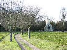
The station takes its name from the road that runs through the dispersed village of Eccles. The church Eccles St. Mary still stands and is one of 124 original round-tower churches in Norfolk. The station is situated in the civil parish of Quidenham, about 2 miles (3 km) north of that village, and 1 mile (1.5 km) north-east of Snetterton Motor Racing Circuit.[1]
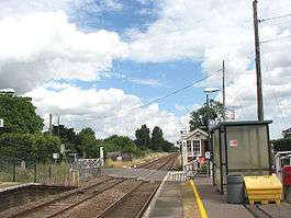
The station is unstaffed and has two platforms, adjacent to a level crossing. Wooden level crossing gates used to be opened and closed manually by a signaller in the local signal box, which is dated 1883. However, in 2012 the signal box was closed and the crossing was renewed with automatic barriers controlled from Cambridge. The redundant signal box stands across the road from the westbound (Cambridge) platform, but is expected to be demolished when the barriers are replaced in 2017.
History
The Bill for the Norwich & Brandon Railway (N&BR) received Royal Assent on 10 May 1844. Work started on the line in 1844 and the line and its stations were opened on 30 July 1845. Eccles Road station opened with the line and was situated then, as now, east of Harling station and west of Attleborough station. The line ran from Ely to Trowse, in Norwich. The link into Norwich was delayed due to the need to build a bridge over the River Wensum that kept the river navigable. One month before the N&BR opened a Bill authorising the amalgamation of the Yarmouth & Norwich Railway with the N&BR came into effect and so Eccles Road station became a Norfolk Railway asset.[2]
Services
As of December 2015, on weekdays there are two westbound trains per day, one operated by East Midlands Trains which calls at Harling Road, Thetford and Ely before continuing on to Liverpool Lime Street, the other operated by Greater Anglia which runs to Cambridge, also calling at all intermediate stations on the line except Lakenheath and Shippea Hill. On Saturdays there are two westbound trains, both operated by Abellio Greater Anglia to Cambridge with the same calling pattern.
In the eastbound direction, from Monday to Saturday there are two trains per day to Norwich calling at all intermediate stations except Spooner Row, both operated by Greater Anglia.[3]
There is no Sunday service.
References
External links
- Map sources for Eccles Road railway station
- Train times and station information for Eccles Road railway station from National Rail
| Wikimedia Commons has media related to Eccles Road railway station. |
| Preceding station | Following station | |||
|---|---|---|---|---|
| Greater Anglia | ||||
| East Midlands Trains Limited services |