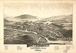
Hadley, New York
| Hadley, New York | |
|---|---|
| Town | |
 Hadley Town Hall | |
| Motto(s): Where the Great Sacandaga meets the mighty Hudson | |
 Hadley, New York Location within the state of New York | |
| Coordinates: 43°19′6″N 73°52′11″W / 43.31833°N 73.86972°W | |
| Country | United States |
| State | New York |
| County | Saratoga |
| Area[1] | |
| • Total | 41.09 sq mi (106.41 km2) |
| • Land | 39.70 sq mi (102.83 km2) |
| • Water | 1.38 sq mi (3.57 km2) |
| Elevation | 1,578 ft (481 m) |
| Population (2010) | |
| • Total | 2,048 |
| • Estimate (2016)[2] | 2,032 |
| • Density | 51.18/sq mi (19.76/km2) |
| Time zone | UTC-5 (Eastern (EST)) |
| • Summer (DST) | UTC-4 (EDT) |
| ZIP code | 12835 |
| Area code(s) | 518 |
| FIPS code | 36-31269 |
| GNIS feature ID | 0979032 |
Hadley (/ˈhædliː/ (![]()
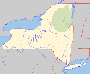
The Town of Hadley is in the northern part of the county and is west of Glens Falls.
History
The first settler arrived around 1788.
The town was formed from parts of the Towns of Greenfield and Northumberland in 1801. The Town of Corinth was taken from Hadley in 1818, and the Town of Day was removed in 1819, bringing the Town of Hadley to its current dimensions.
In 1930, the Conklingville Dam by the west town line helped create the Sacandaga Reservoir and controlled flooding.
The Hadley Mountain Fire Observation Station and Hadley Parabolic Bridge are listed on the National Register of Historic Places.[4]
Geography
According to the United States Census Bureau, the town has a total area of 41.1 square miles (106 km2), of which, 39.8 square miles (103 km2) of it is land and 1.3 square miles (3.4 km2) of it (3.26%) is water.
The town is within the Adirondack Park. The north and east town lines are the border of Warren County.
A small part of the eastern end of the Great Sacandaga Lake (formerly the "Sacandaga Reservoir") is by the west town line and the Sacandaga River divides the town laterally and enters the Hudson River by the east town line.
New York State Route 9N passes through the southeast part of Hadley.
Demographics
| Historical population | |||
|---|---|---|---|
| Census | Pop. | %± | |
| 1820 | 798 | — | |
| 1830 | 829 | 3.9% | |
| 1840 | 865 | 4.3% | |
| 1850 | 1,003 | 16.0% | |
| 1860 | 1,017 | 1.4% | |
| 1870 | 1,039 | 2.2% | |
| 1880 | 1,095 | 5.4% | |
| 1890 | 1,103 | 0.7% | |
| 1900 | 914 | −17.1% | |
| 1910 | 672 | −26.5% | |
| 1920 | 581 | −13.5% | |
| 1930 | 841 | 44.8% | |
| 1940 | 679 | −19.3% | |
| 1950 | 801 | 18.0% | |
| 1960 | 982 | 22.6% | |
| 1970 | 1,128 | 14.9% | |
| 1980 | 1,351 | 19.8% | |
| 1990 | 1,628 | 20.5% | |
| 2000 | 1,971 | 21.1% | |
| 2010 | 2,048 | 3.9% | |
| Est. 2016 | 2,032 | [2] | −0.8% |
| U.S. Decennial Census[5] | |||
As of the census[6] of 2000, there were 1,971 people, 730 households, and 538 families residing in the town. The population density was 49.6 people per square mile (19.1/km²). There were 990 housing units at an average density of 24.9 per square mile (9.6/km²). The racial makeup of the town was 97.77% White, 1.01% African American, 0.20% Native American, 0.15% Asian, 0.05% from other races, and 0.81% from two or more races. Hispanic or Latino of any race were 0.15% of the population.
There were 730 households out of which 35.1% had children under the age of 18 living with them, 57.8% were married couples living together, 10.4% had a female householder with no husband present, and 26.3% were non-families. 19.3% of all households were made up of individuals and 7.8% had someone living alone who was 65 years of age or older. The average household size was 2.67 and the average family size was 3.04.
In the town, the population was spread out with 26.2% under the age of 18, 8.0% from 18 to 24, 29.5% from 25 to 44, 22.4% from 45 to 64, and 13.9% who were 65 years of age or older. The median age was 37 years. For every 100 females, there were 99.1 males. For every 100 females age 18 and over, there were 95.7 males.
The median income for a household in the town was $38,150, and the median income for a family was $42,438. Males had a median income of $35,694 versus $21,810 for females. The per capita income for the town was $17,560. About 6.1% of families and 9.2% of the population were below the poverty line, including 11.9% of those under age 18 and 9.9% of those age 65 or over.
Communities and locations in Hadley
- Bell Brook Pond – A small artificial lake by the west town line.
- Hadley – The hamlet of Hadley is near the east town line and the mouth of the Sacandaga River at the junction of County Roads 1 and 4..
- Lynnwood – A hamlet in the west part of the town at the junction of County Roads 7 and 8.
- Mount Anthony – The highest peak in the town in its southeast corner.
- Rockwell Falls – A waterfall by Hadley village.
- Stewart Bridge Reservoir – A reservoir on the Sacandaga River.
- Stewart's Dam – An earthen dam on the Sacandaga River, creating Stewart Bridge Reservoir.
References
- ↑ "2016 U.S. Gazetteer Files". United States Census Bureau. Retrieved Jul 5, 2017.
- 1 2 "Population and Housing Unit Estimates". Retrieved June 9, 2017.
- ↑ "Hadley". Merriam-Webster. Retrieved 12 November 2014.
- ↑ National Park Service (2009-03-13). "National Register Information System". National Register of Historic Places. National Park Service.
- ↑ "Census of Population and Housing". Census.gov. Retrieved June 4, 2015.
- ↑ "American FactFinder". United States Census Bureau. Retrieved 2008-01-31.
External links
Coordinates: 43°19′02″N 73°50′53″W / 43.31722°N 73.84806°W
Municipalities and communities of Saratoga County, New York, United States | ||
|---|---|---|
| Cities | 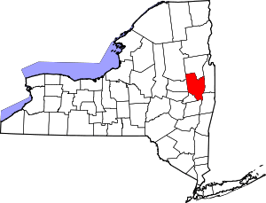 | |
| Towns | ||
| Villages | ||
| CDPs | ||
| Other hamlets | ||
| Footnotes | ‡This populated place also has portions in an adjacent county or counties | |