Gutiérrez Province
| Gutiérrez Province Provincia de Gutiérrez | |
|---|---|
| Province | |
 | |
| Etymology: José Santos Gutiérrez | |
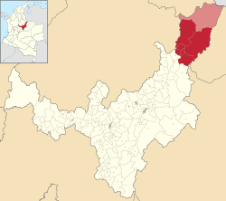 Location of Gutiérrez Province in Colombia | |
| Coordinates: 6°25′00″N 72°25′00″W / 6.41667°N 72.41667°WCoordinates: 6°25′00″N 72°25′00″W / 6.41667°N 72.41667°W | |
| Country | Colombia |
| Department | Boyacá |
| Capital | El Cocuy |
| Municipalities | 6 |
| Time zone | UTC−5 (COT) |
| Indigenous groups | Lache |
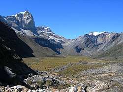
The Gutiérrez Province is a subregion of the Colombian Department of Boyacá. The subregion is formed by six municipalities.[1] The province is named after Colombian president José Santos Gutiérrez.[2] The highest mountains of the Eastern Ranges of the Colombian Andes are located in the Gutiérrez Province. The Ritacuba Blanco, with 5,410 metres (17,750 ft) the highest peak in the Eastern Ranges is the second-most prominent peak of Colombia, after the highest double mountain Pico Cristóbal Colón.[3]
Municipalities
Chiscas • El Cocuy • El Espino • Guacamayas • Güicán • Panqueba
References
- ↑ (in Spanish) Provincias de Boyacá
- ↑ (in Spanish) Provincia de Gutiérrez
- ↑ Colombia: 22 Mountain Summits with Prominence of 1,500 meters or greater - Peaklist.org
This article is issued from
Wikipedia.
The text is licensed under Creative Commons - Attribution - Sharealike.
Additional terms may apply for the media files.