Gunung Ciremai National Park
| Mount Ciremai National Park | |
|---|---|
| Taman Nasional Gunung Ciremai | |
|
IUCN category II (national park) | |
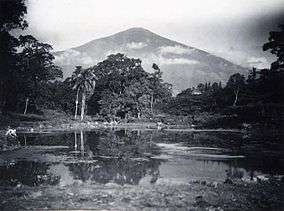 Lake at the foot of Mt Ciremai (ca.1920-33) | |
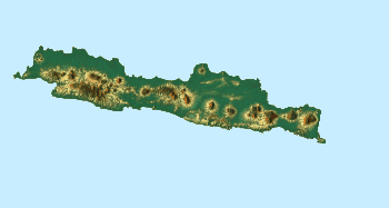 Gunung Ciremai NP Location in Java  Gunung Ciremai NP Gunung Ciremai NP (Indonesia) | |
| Location | West Java, Indonesia |
| Nearest city | Cirebon |
| Coordinates | 6°55′S 108°20′E / 6.917°S 108.333°ECoordinates: 6°55′S 108°20′E / 6.917°S 108.333°E |
| Area | 155 km2 |
| Established | 2004 |
| Visitors | 15,126 (in 2007[1]) |
| Governing body | Ministry of Environment and Forestry |
| Website |
btngciremai (Blog) |
Mount Ciremai National Park is located around 50 km to the south of the city of Cirebon in West Java, Indonesia. The park extends into the Kuningan and Majalengka regencies south of Cirebon. The park surrounds Mt Ceremai, an active volcano, the highest peak in West Java. Groups of hikers, including parties of students, often climb the peak although care is needed.
Various types of endemic or endangered flora and fauna are found in the park[2] which include the following:
- Flora: pines (Pinus merkusii), Castanopsis javanica (known locally as Saninten), Randu tiang (Fragraera blumii), Nangsi (Villubrunes rubescens), Macaranga (Macaranga denticulatan), Pasang (Lithocarpus sundaicus), Elaeocarpus (Elaeocarpus stipularis), various species of fig trees (Ficus), Ardisia cymosa, and Platea latifolia,
- Fauna: leopards, deer (Muntiacus muntjak or Javan muntjac), Echidna (Zaglossus bruijni), monkeys (Javan surili), the Javan hawk-eagle and various species of python.
See also
References
- ↑ Forestry statistics of Indonesia 2007, retrieved 20 May 2010
- ↑ These are listed in the Official Letter issued by the Forestry Minister, No SK 424/Menhut-II/2004 issued on 19 October 2004 noted in the External links section below.
External links
| Wikimedia Commons has media related to Gunung Ciremai National Park. |
| Wikivoyage has a travel guide for Mount Ciremai National Park. |
This article is issued from
Wikipedia.
The text is licensed under Creative Commons - Attribution - Sharealike.
Additional terms may apply for the media files.