Grosse Pointe Shores, Michigan
| Grosse Pointe Shores, Michigan | ||
|---|---|---|
| City | ||
| Village of Grosse Pointe Shores, A Michigan City | ||
 | ||
| ||
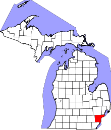
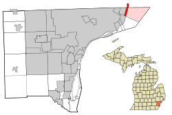 Location in Wayne County and Macomb County in the U.S. state of Michigan | ||
| Coordinates: 42°26′19″N 82°52′15″W / 42.43861°N 82.87083°WCoordinates: 42°26′19″N 82°52′15″W / 42.43861°N 82.87083°W | ||
| Country | United States of America | |
| State | Michigan | |
| Counties | Wayne, Macomb | |
| Government | ||
| • Mayor | Thaddeus J. Kedzierski | |
| Area[1] | ||
| • Total | 19.23 sq mi (49.81 km2) | |
| • Land | 1.15 sq mi (2.98 km2) | |
| • Water | 18.08 sq mi (46.83 km2) | |
| Elevation | 581 ft (177 m) | |
| Population (2010)[2] | ||
| • Total | 3,008 | |
| • Estimate (2017)[3] | 2,919 | |
| • Density | 160/sq mi (60/km2) | |
| Time zone | UTC-5 (EST) | |
| • Summer (DST) | UTC-4 (EDT) | |
| ZIP codes | 48230, 48236 | |
| Area code(s) | 313 | |
| FIPS code | 26-82453[4] | |
| GNIS feature ID | 2398212[5] | |
| Website | gpshoresmi.gov | |

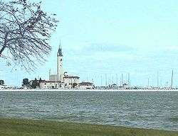
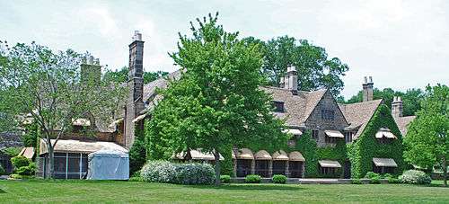
Grosse Pointe Shores is a city in the U.S. state of Michigan. The city, which is entirely residential, is the location of the Grosse Pointe Yacht Club on Lake Saint Clair. The city's population was 3,008 at the 2010 census.[6] It has the 70th highest income for a municipality with over 1,000 citizens in the country and the second highest income in the state of Michigan.
On February 24, 2009, the residents of Grosse Pointe Shores voted to incorporate as a city with the name "Village of Grosse Pointe Shores, A Michigan City," which took place on April 1.[7][8][9] Prior to incorporation as a city, the village encompassed the entire area of two small townships. Most of the former village was within Grosse Pointe Township in Wayne County. A tiny portion of the village was within Lake Township in Macomb County.
History
Grosse Pointe Shores was incorporated as a village in 1911. The village incorporated as a city in 2009. In 2011, the city government stated that it is considering trying to move all of the city into Macomb County, since Macomb County has lower taxes than Wayne County.[10]
Geography
According to the United States Census Bureau, the city has a total area of 19.23 square miles (49.81 km2), of which 1.15 square miles (2.98 km2) is land and 18.08 square miles (46.83 km2) is water,[1] (part of Lake St. Clair).
Demographics
| Historical population | |||
|---|---|---|---|
| Census | Pop. | %± | |
| 1920 | 519 | — | |
| 1930 | 621 | 19.7% | |
| 1940 | 801 | 29.0% | |
| 1950 | 1,032 | 28.8% | |
| 1960 | 2,301 | 123.0% | |
| 1970 | 3,042 | 32.2% | |
| 1980 | 3,122 | 2.6% | |
| 1990 | 2,955 | −5.3% | |
| 2000 | 2,823 | −4.5% | |
| 2010 | 3,008 | 6.6% | |
| Est. 2017 | 2,919 | [3] | −3.0% |
| U.S. Decennial Census[11] | |||
2010 census
As of the census[2] of 2010, there were 3,008 people, 1,201 households, and 911 families residing in the city. The population density was 2,615.7 inhabitants per square mile (1,009.9/km2). There were 1,350 housing units at an average density of 1,173.9 per square mile (453.2/km2). The racial makeup of the city was 92.8% White, 1.9% African American, 0.3% Native American, 3.8% Asian, 0.2% from other races, and 1.0% from two or more races. Hispanic or Latino of any race were 1.9% of the population.
There were 1,201 households of which 24.6% had children under the age of 18 living with them, 68.0% were married couples living together, 4.8% had a female householder with no husband present, 3.0% had a male householder with no wife present, and 24.1% were non-families. 21.1% of all households were made up of individuals and 13.6% had someone living alone who was 65 years of age or older. The average household size was 2.50 and the average family size was 2.92.
The median age in the city was 52.2 years. 19.6% of residents were under the age of 18; 5.1% were between the ages of 18 and 24; 14.2% were from 25 to 44; 33.5% were from 45 to 64; and 27.6% were 65 years of age or older. The gender makeup of the city was 50.1% male and 49.9% female.
2000 census
As of the census [4] of 2000, there were 2,823 people, 1,058 households, and 859 families residing in the village. The population density was 2,470.6 per square mile (956.1/km²). There were 1,096 housing units at an average density of 959.2 per square mile (371.2/km²). The racial makeup of the village was 93.80% White, 0.60% African American, 0.25% Native American, 4.07% Asian, 0.43% from other races, and 0.85% from two or more races. Hispanic or Latino of any race were 1.74% of the population.
There were 1,058 households out of which 28.1% had children under the age of 18 living with them, 74.5% were married couples living together, 4.6% had a female householder with no husband present, and 18.8% were non-families. 17.1% of all households were made up of individuals and 12.5% had someone living alone who was 65 years of age or older. The average household size was 2.67 and the average family size was 3.01.
The median income for a household in the village was $222,882, and the median income for a family was $289,680. Males had a median income of $100,000 versus $59,375 for females. The per capita income for the village was $197,639. About 2.7% of families and 3.0% of the population were below the poverty line, including 4.6% of those under age 18 and 3.4% of those age 65 or over.
Education
The city lies within two separate school districts.[12][13]
The portion in Wayne County is within the Grosse Pointe Public School System. Residents of the GPPSS area are divided between Ferry Elementary School and Monteith Elementary School, and all residents of that section are zoned to Parcells Middle School and Grosse Pointe North High School; all of these schools are in Grosse Pointe Woods.[14]
The portion of the community in Macomb County is within the South Lake School District.[15][16][17]
Notable people
- Edsel Ford, son of Henry Ford, and president of Ford Motor Company;
- Ralph Wilson, founder, owner, and president of the Buffalo Bills;
- William Clay Ford, Sr., grandson of Henry Ford, son of Edsel Ford
- Manuel Moroun, billionaire businessman, owner of the Ambassador Bridge
References
- 1 2 "US Gazetteer files 2010". United States Census Bureau. Archived from the original on 2012-01-24. Retrieved 2012-11-25.
- 1 2 "American FactFinder". United States Census Bureau. Retrieved 2012-11-25.
- 1 2 "American FactFinder". Retrieved June 18, 2018.
- 1 2 "American FactFinder". United States Census Bureau. Archived from the original on 2013-09-11. Retrieved 2008-01-31.
- ↑ U.S. Geological Survey Geographic Names Information System: Grosse Pointe Shores, Michigan
- ↑ "Race, Hispanic or Latino, Age, and Housing Occupancy: 2010 Census Redistricting Data (Public Law 94-171) Summary File (QT-PL), Village of Grosse Pointe Shores city, Michigan". U.S. Census Bureau, American FactFinder 2. Archived from the original on September 11, 2013. Retrieved September 7, 2011.
- ↑ Detroit News, February 25, 2009
- ↑ Al, Tanveer (May 7, 2008). "Grosse Pointe Shores voters embrace cityhood". The Detroit News. detnews.com.
- ↑ "Grosse Pointe Shores > Home". gpshoresmi.gov.
- ↑ Williams, Candice. "Grosse Pointe Shores eyes Macomb move." The Detroit News. September 12, 2011. Retrieved on September 18, 2011.
- ↑ "Census of Population and Housing". Census.gov. Archived from the original on May 12, 2015. Retrieved June 4, 2015.
- ↑ "SCHOOL DISTRICT REFERENCE MAP (2010 CENSUS): Wayne County, MI." (Archive) U.S. Census Bureau. Retrieved on November 1, 2012.
- ↑ "Amendments to Zoning Ordinance." Grosse Pointe Shores. Retrieved on January 9, 2017. See "Zoning Map" on PDF p. 24/25
- ↑ "District Map." Grosse Pointe Public School System. Retrieved on January 8, 2017.
- ↑ "SL_header800_2009goldnotag.jpg Archived 2013-01-30 at the Wayback Machine.." South Lake School District. Retrieved on November 1, 2012.
- ↑ "District Map." (Archive) South Lake School District. Retrieved on November 1, 2012.
- ↑ "SCHOOL DISTRICT REFERENCE MAP (2010 CENSUS): Macomb County, MI." (Archive) U.S. Census Bureau. Retrieved on November 1, 2012.
External links
Places adjacent to Grosse Pointe Shores, Michigan | ||||||||||
|---|---|---|---|---|---|---|---|---|---|---|
| ||||||||||
Municipalities and communities of Macomb County, Michigan, United States | ||
|---|---|---|
| Cities | 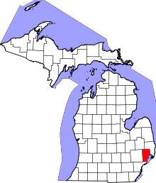 | |
| Villages | ||
| Charter townships | ||
| General law townships | ||
| Unincorporated community |
| |
| Footnotes | ‡This populated place also has portions in an adjacent county or counties | |
Municipalities and communities of Wayne County, Michigan, United States | ||
|---|---|---|
| Cities |
|  |
| Charter townships | ||
| General law townships | ||
| Unincorporated communities | ||
| Ghost Towns | ||
| Footnotes | ‡This populated place also has portions in an adjacent county or counties | |