Memphis, Michigan
| Memphis, Michigan | |
|---|---|
| City | |
| Motto(s): A Pleasant Place to Live | |
 Location of Memphis, Michigan | |
| Coordinates: 42°53′47″N 82°46′15″W / 42.89639°N 82.77083°W | |
| Country | United States |
| State | Michigan |
| Counties | Macomb, St. Clair |
| Area[1] | |
| • Total | 1.15 sq mi (2.98 km2) |
| • Land | 1.12 sq mi (2.90 km2) |
| • Water | 0.03 sq mi (0.08 km2) |
| Elevation | 755 ft (230 m) |
| Population (2010)[2] | |
| • Total | 1,183 |
| • Estimate (2017)[3] | 1,191 |
| • Density | 1,000/sq mi (400/km2) |
| Time zone | UTC-5 (Eastern (EST)) |
| • Summer (DST) | UTC-4 (EDT) |
| Area code(s) | 810 |
| FIPS code | 26-52960[4] |
| GNIS feature ID | 1624727[5] |
Memphis is a city on the line between Macomb and St. Clair counties in the U.S. state of Michigan. The population was 1,183 at the 2010 census.
History
The area of Memphis was first settled by members of the Wells family from Albany (New York), with Anthony Wells residing in the area from 1834 and James Wells from 1835. The fledgling community was originally called Wells Settlement with the name "Memphis" first being applied in 1848 with the local postal outlet opening that 8 December as Memphis Post Office, "Memphis" being chosen due to the community's location of a bluff overlooking a river (the Belle) paralleling the location of ancient Memphis "the City on the Nile". Memphis would be incorporated as a village 4 April 1865 with status as a city granted in 1953.[6][7]
Geography
According to the United States Census Bureau, the city has a total area of 1.15 square miles (2.98 km2), of which 1.12 square miles (2.90 km2) is land and 0.03 square miles (0.08 km2) is water.[1] The city is evenly divided between Macomb and St. Clair counties. The Belle River passes through the city. Memphis is also known for its slogan: "A Pleasant Place To Live."
Demographics
| Historical population | |||
|---|---|---|---|
| Census | Pop. | %± | |
| 1870 | 385 | — | |
| 1880 | 579 | 50.4% | |
| 1890 | 588 | 1.6% | |
| 1900 | 586 | −0.3% | |
| 1910 | 557 | −4.9% | |
| 1920 | 452 | −18.9% | |
| 1930 | 574 | 27.0% | |
| 1940 | 630 | 9.8% | |
| 1950 | 800 | 27.0% | |
| 1960 | 996 | 24.5% | |
| 1970 | 1,121 | 12.6% | |
| 1980 | 1,171 | 4.5% | |
| 1990 | 1,221 | 4.3% | |
| 2000 | 1,129 | −7.5% | |
| 2010 | 1,183 | 4.8% | |
| Est. 2017 | 1,191 | [3] | 0.7% |
| U.S. Decennial Census[8] | |||
As of 2000 the median income for a household in the city was $41,705, and the median income for a family was $52,679. Males had a median income of $41,932 versus $27,019 for females. The per capita income for the city was $19,983. About 7.8% of families and 10.0% of the population were below the poverty line, including 10.5% of those under age 18 and 15.9% of those age 65 or over.
2010 census
As of the census[2] of 2010, there were 1,183 people, 474 households, and 320 families residing in the city. The population density was 1,056.3 inhabitants per square mile (407.8/km2). There were 514 housing units at an average density of 458.9 per square mile (177.2/km2). The racial makeup of the city was 97.6% White, 0.8% African American, 0.3% Native American, 0.5% from other races, and 0.8% from two or more races. Hispanic or Latino of any race were 2.1% of the population.
There were 474 households of which 34.8% had children under the age of 18 living with them, 49.8% were married couples living together, 13.9% had a female householder with no husband present, 3.8% had a male householder with no wife present, and 32.5% were non-families. 27.8% of all households were made up of individuals and 11.9% had someone living alone who was 65 years of age or older. The average household size was 2.47 and the average family size was 3.02.
The median age in the city was 39.4 years. 24.3% of residents were under the age of 18; 7.9% were between the ages of 18 and 24; 26% were from 25 to 44; 27.9% were from 45 to 64; and 13.8% were 65 years of age or older. The gender makeup of the city was 47.8% male and 52.2% female.
Education
The Memphis Community School District has an elementary school and a junior/senior high school. Its sports teams are nicknamed the Yellowjackets.
Maryglade College was located in Memphis from 1960 until May 1972.
"The Thing"
Over the winter of 1884-1885 local father-&-son mechanics John and Thomas Clegg constructed a four-seater road vehicle powered by a single-cylinder steam engine with a boiler in the rear. Referred to as "The Thing" the Cleggs' invention marks the first recorded instance of an automobile made in Michigan - a state which would become iconic for automobile manufacture - although the Cleggs' vehicle itself would prove inconsequential as thirty some test drives over the summer of 1885 established its operation to be unviably arduous.[9] However a roadside historical marker on the east civic limits of Memphis commemorates the Cleggs' invention.[10]
|
References
- 1 2 "US Gazetteer files 2010". United States Census Bureau. Archived from the original on 2012-07-14. Retrieved 2012-11-25.
- 1 2 "American FactFinder". United States Census Bureau. Retrieved 2012-11-25.
- 1 2 "American FactFinder". Retrieved June 18, 2018.
- ↑ "American FactFinder". United States Census Bureau. Retrieved 2008-01-31.
- ↑ "US Board on Geographic Names". United States Geological Survey. 2007-10-25. Retrieved 2008-01-31.
- ↑ Romig, Walter (1986). Michigan Place Names: the history of the founding & the naming of more than 5000 past & present Michigan communities. Detroit MI: Wayne State University Press. p. 361. ISBN 0-8143-1838-X.
- ↑ "Riley Township Extracted From History of St. Clair County Michigan Chicago 1883". Retrieved 9 February 2018.
- ↑ "Census of Population and Housing". Census.gov. Retrieved June 4, 2015.
- ↑ Pound, Arthur (1934). The Turning Wheel: the story of General Motors through 25 years 1908-1933. Garden City NY: Doubleday Doran & co. pp. 32–33. ISBN 9785877530294.
- ↑ http://www.michmarkers.com/startup.asp?startpage=L0824.htm
- ↑ Historical Markers Archived 2008-05-13 at the Wayback Machine., Macomb County Historical Commission
- ↑ Michigan Historical Marker: "The Thing"
External links
- City of Memphis Official Website
- Memphis Community School District
- NEMC-TV6 City of Memphis Public-access television Channel website
Municipalities and communities of Macomb County, Michigan, United States | ||
|---|---|---|
| Cities | 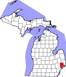 | |
| Villages | ||
| Charter townships | ||
| General law townships | ||
| Unincorporated community |
| |
| Footnotes | ‡This populated place also has portions in an adjacent county or counties | |
Municipalities and communities of St. Clair County, Michigan, United States | ||
|---|---|---|
| Cities | 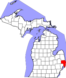 | |
| Villages | ||
| Charter townships | ||
| General law townships | ||
| CDP | ||
| Other unincorporated communities |
| |
| Footnotes | ‡This populated place also has portions in an adjacent county or counties | |
Coordinates: 42°53′47″N 82°46′08″W / 42.89639°N 82.76889°W