Walpole Island First Nation
| Walpole Island 46 Bkejwanong | |
|---|---|
| Unceded territory | |
| Walpole Island Indian Reserve No. 46 | |
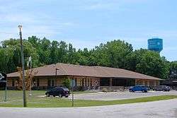 Governance building | |
 Walpole Island 46 | |
| Coordinates: 42°33′N 82°29′W / 42.550°N 82.483°WCoordinates: 42°33′N 82°29′W / 42.550°N 82.483°W | |
| Country |
|
| Province |
|
| County | Lambton |
| First Nation | Walpole Island |
| Government | |
| • Chief | Dan Miskokomon |
| • Federal riding | Lambton—Kent—Middlesex |
| • Prov. riding | Lambton—Kent—Middlesex |
| Area[1] | |
| • Land | 137.47 km2 (53.08 sq mi) |
| Population (2006)[1] | |
| • Total | 1,878 |
| • Density | 13.66/km2 (35.4/sq mi) |
| Time zone | UTC-5 (EST) |
| • Summer (DST) | UTC-4 (EDT) |
| Area code(s) | 519 and 226 |
Walpole Island is an island and First Nation reserve in southwestern Ontario, Canada, on the border between Ontario and Michigan in the United States. It is located in the mouth of the St. Clair River on Lake St. Clair, about 121 kilometres (75 mi) by road from Windsor,[2] Ontario and 124 kilometres (77 mi) from Detroit, Michigan.[3]
It is unceded territory and is inhabited by the Ojibwe, Potawatomi, and Odawa peoples of the Walpole Island First Nation, who call it Bkejwanong, meaning "where the waters divide" in Anishinaabemowin.[4][5] In addition to Walpole Island, the reserve includes Squirrel Island, St. Anne Island, Seaway Island, Bassett Island, and Potawatomi Island. The river or creeks that separate these islands provide the area with its other commonly used name, Swejwanong or "many forks of a river."[5]
It is independent of, but within the geographic region of Lambton County and adjoins the municipality of Chatham-Kent and the township of St. Clair. Across the St. Clair River to the west are the United States city of Algonac, Michigan, and Clay Township. Harsen's Island, also unceded Anishinaabe territory, is now on the west side of the international border line. The border was redrawn in the 19th century following disputes between the United Kingdom and the United States; their governments were oblivious to the interests and rights of the Indigenous peoples living on and using these lands. Walpole Island is known as the resting place of Tecumseh, prominent 19th-century leader of the Native American tribe known as the Shawnee.
The Island is also home to many different environmental efforts including the Walpole Island Land Trust[6] and the Purple Martin Project[7] run by Richard Carr.
History
Settlement (1600s–1800s)
In the late 1600s and early 1700s, what is now known as Walpole Island and the surrounding area was settled by people from the Ojibwe and Odawa nations.[8] In 1844, Jesuits from nearby Sandwich built a mission at the northern point of Walpole Island at the Highbanks.[9] This raised tensions with the Anishinaabeg as the Jesuits were not invited to build on the island and they cut down oak trees that the community did not want to be cut. The relationship between the two groups was further antagonized by the theological debate that Father Pierre Chazelle held with Chief Peterwegeschick and other chief leaders on July 31, 1844.[10] In 1850 the Jesuits left after the mission was razed.[11]
Deforestation of the island (1869–1883)
Due to a number of contracts for harvesting oak on the island, drawn up by non- Native resource industries, a large amount of Walpole Island was deforested. The nature of these contracts "created a lasting mistrust between the community, Indian Affairs, and non-Native resource industries."[12]
Illegal hunting prohibitions (1884–1899)
As part of an effort to colonize the island, Indian Affairs produced an illegal prohibition on the hunting of ducks on St. Anne's Island. The prohibition was lifted once Aboriginal Title was reaffirmed in 1899.[13]
20th Century Industrialization of St. Clair River
By the early twentieth century, the river surrounding Walpole Island was heavily trafficked with industrial freight.[14]
Demographics
As of January 2011, the registered population of the Walpole Island First Nation is 4315 members, of whom 2213 live on the reserve, 22 live on another reserve, and 2080 live off reserve.[15]
| Canada census – Walpole Island 46 community profile | |||
|---|---|---|---|
| 2006 | |||
| Population: | 1878 (1.9% from 2001) | ||
| Land area: | 137.28 km2 (53.00 sq mi) | ||
| Population density: | 13.7/km2 (35/sq mi) | ||
| Median age: | 30.9 (M: 29.0, F: 32.9) | ||
| Total private dwellings: | 753 | ||
| Median household income: | $27,627 | ||
| References: 2006[16] earlier[17] | |||
| Historical population | ||
|---|---|---|
| Year | Pop. | ±% |
| 1991 | 1,370 | — |
| 1996 | 1,525 | +11.3% |
| 2001 | 1,843 | +20.9% |
| 2006 | 1,878 | +1.9% |
| [18] 2011 population unavailable. | ||
Images
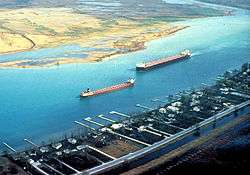 St. Clair River with Walpole Island in the background
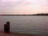 View of Walpole Island as seen from across the St. Clair River
 Entry to Walpole Island from ferry to Algonac
See also
- Bauzhi-Geezhig-Waeshikum
- Alexander McKee - Indian Department agent who founded the Walpole Island settlement
- Walpole–Algonac Ferry
References
| Wikimedia Commons has media related to Walpole Island (Ontario). |
- 1 2 "Walpole Island 46 community profile". 2011 Census data. Statistics Canada. Retrieved 2015-06-23.
- ↑ "Walpole Island, Ontario to Windsor, Ontario". Google Maps. Google. 2014. Retrieved 20 December 2014.
- ↑ "Walpole Island, Ontario to Detroit, Michigan". Google Maps. Google. 2014. Retrieved 20 December 2014.
- ↑ Walpole Island Heritage Centre - About nin.da.waab.jig
- 1 2 Fehr, Rick (2011). Who Has Traded Cash For Creation? Approaching An Anishinaabeg Informed Environmental History On Bkejwanong Territory (PhD). Dissertations & Theses @ York University; ProQuest Dissertations & Theses Global. p. 9.
- ↑ "Walpole Island Land Trust -". walpolelandtrust.com. Retrieved 2015-10-14.
- ↑ "Purple martin project thriving locally | Chatham Voice". Retrieved 2015-10-14.
- ↑ VanWynsberghe, Robert (2002). AlterNatives : community, identity, and environmental justice on Walpole Island. Boston: Allyn and Bacon. p. 63. ISBN 9780205349524.
- ↑ Fehr 2011, p. 63.
- ↑ Fehr 2011, p. 66.
- ↑ Fehr 2011, p. 63-64.
- ↑ Fehr 2011, p. 171.
- ↑ Fehr 2011, p. 171-172.
- ↑ Fehr 2011, p. 91.
- ↑ "Walpole Island Registered Population", Indian and Northern Affairs Canada - First Nation Profiles
- ↑ "2006 Community Profiles". Canada 2006 Census. Statistics Canada. March 30, 2011. Retrieved 2011-02-24.
- ↑ "2001 Community Profiles". Canada 2001 Census. Statistics Canada. February 17, 2012.
- ↑ Statistics Canada: 1996, 2001, 2006 census
Places adjacent to Walpole Island First Nation | |
|---|---|