Greene Township, St. Joseph County, Indiana
| Greene Township | |
|---|---|
| Township | |
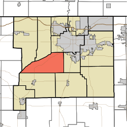 Location in St. Joseph County | |
| Coordinates: 41°37′31″N 86°20′00″W / 41.62528°N 86.33333°WCoordinates: 41°37′31″N 86°20′00″W / 41.62528°N 86.33333°W | |
| Country |
|
| State |
|
| County | St. Joseph |
| Government | |
| • Type | Indiana township |
| Area | |
| • Total | 34.57 sq mi (89.54 km2) |
| • Land | 34.31 sq mi (88.86 km2) |
| • Water | 0.26 sq mi (0.68 km2) 0.76% |
| Elevation[1] | 735 ft (224 m) |
| Population (2000) | |
| • Total | 3,040 |
| • Density | 88.6/sq mi (34.2/km2) |
| Time zone | UTC-5 (Eastern (EST)) |
| • Summer (DST) | UTC-4 (EDT) |
| ZIP codes | 46554, 46614, 46619 |
| Area code(s) | 574 |
| GNIS feature ID | 452852 |
Greene Township is one of thirteen townships in St. Joseph County, in the U.S. state of Indiana.[2] As of the 2000 census, its population was 3,040.[3]
Greene Township was established in 1836.[4]
Geography
According to the United States Census Bureau, Greene Township covers an area of 34.57 square miles (89.5 km2); of this, 34.31 square miles (88.9 km2) (99.24 percent) is land and 0.26 square miles (0.67 km2) (0.76 percent) is water.
Adjacent townships
- Warren Township (north)
- Portage Township (northeast)
- Centre Township (east)
- Union Township (southeast)
- Liberty Township (southwest)
- Lincoln Township, LaPorte County (west)
- Olive Township (northwest)
Cemeteries
The township contains Sumption Prairie Cemetery. There is another township owned cemetery located on Pine road between Layton and Miller roads.
Major highways
Lakes
- Catfish Lake
- Dollar Lake
- Goodman Lake
- Kale Lake
- Sousley Lake
School districts
- South Bend Community School Corporation
Political districts
- Indiana's 2nd congressional district
- State House District 7
- State Senate District 9
References
- United States Census Bureau 2008 TIGER/Line Shapefiles
- United States Board on Geographic Names (GNIS)
- IndianaMap
- ↑ "US Board on Geographic Names". United States Geological Survey. October 25, 2007. Retrieved 2017-05-09.
- ↑ "Greene Township". Geographic Names Information System. United States Geological Survey. Retrieved 2009-07-07.
- ↑ United States Census Bureau American FactFinder
- ↑ Howard, Timothy Edward (1907). A History of St. Joseph County, Indiana. Lewis publishing Company. p. 276.
External links
Places adjacent to Greene Township, St. Joseph County, Indiana | |
|---|---|
Municipalities and communities of St. Joseph County, Indiana, United States | ||
|---|---|---|
| Cities | ||
| Towns | ||
| Townships | ||
| CDPs | ||
| Unincorporated communities |
| |
| Footnotes | ‡This populated place also has portions in an adjacent county or counties | |
This article is issued from
Wikipedia.
The text is licensed under Creative Commons - Attribution - Sharealike.
Additional terms may apply for the media files.