Grand Port District
| Grand Port District | |
|---|---|
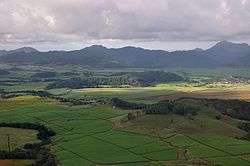 Sugar cane plantations near Rose Belle | |
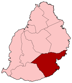 Map of Mauritius island with Grand Port District highlighted | |
| Country |
|
| Government[1] | |
| • Type | District Council |
| • Chairman | Mr. Ruggoo Yashveer |
| • Vice Chairman | Mr. Seegobin Megduth |
| Area | |
| • Total | 260.3 km2 (100.5 sq mi) |
| Population (2015)[2] | |
| • Total | 112,997 |
| • Rank | 5th in Mauritius |
| • Density | 430/km2 (1,100/sq mi) |
| Time zone | UTC+4 (MUT) |
| ISO 3166 code | MU-GP (Grand Port) |
Grand Port (Creole pronunciation: [ɡʁɑ̃ poː]) is a district of Mauritius, situated in the east of the island. The name means "large port" in French. The district has an area of 260.3 km2 and the population estimate was at 112,997 as of 31 December 2015.[2]
History
Grand Port is named after the village of 'Old Grand Port' which saw the first Dutch landing and the first port of the island. It is centered on the town of Mahébourg on the coast, inside the Grand Port Bay. Built by the Dutch and later taken over by the French, the town is a reminder of the colonial past of the island.
In 1810, a French squadron of frigates achieved an ultimately futile naval victory over a comparable British squadron at the Battle of Grand Port, near the Île de la Passe.
Places of interest
The district's most well known and popular beaches is Blue Bay, one of the finest bathing spots on the island surrounded by a semicircle of filao trees. Situated on the southeast coast, not far from Mahébourg, Blue Bay offers a fine stretch of white sandy beach, and a deep, clear, light-blue bathing pool. There is also scope for yachting and windsurfing. Many structures in the district reflect the colonial past of the district.
Just north of Mahebourg, Vallée de Ferney contains indigenous forests and a range of endangered plants and animals. Off the coast, Ile aux Aigrettes is a small island where the original ecosystems of Mauritius have been to some degree rehabilitated. The bay of Grand-bay also known as Mahebourg bay itself offers a relatively well preserved underwater flora and fauna which makes it an ideal snorkeling site.
Places
The Grand Port District include different regions; however, some regions are further divided into different suburbs.[2][3] Midlands and Seizième Mille village council areas are geographically in Plaines Wilhems district and have thus not been included in the places found in Grand Port. However, the residents do vote in local elections for the Grand Port District council. Note that the statistics do not take into account that Camp Carol was created out of Trois Boutiques and that Trois Boutiques was renamed Trois Boutiques (Union Vale) in 2011 following the new Local Government Act.[4]
Places by population
| Places by population, area and density | ||||||||
|---|---|---|---|---|---|---|---|---|
| Place | Population[5] | Area in km²[6] | Population density per km²[6] | |||||
| Bambous Virieux | 1,496 | 7.7 | 194.5 | |||||
| Bananes | 660 | 10.08 | 65.5 | |||||
| Beau-Vallon, Mauritius | 6,904 | 10.13 | 681.5 | |||||
| Bois des Amourettes | 1,880 | 6.52 | 220.7 | |||||
| Cluny | 1,549 | 11.18 | 138.6 | |||||
| Grand Bel Air | 1,538 | 2.8 | 549.3 | |||||
| Grand Sable | 2,182 | 5.02 | 434.7 | |||||
| L'Escalier (West in Savanne district) | 7,770 | 12.18 | 637.9 | |||||
| Mahébourg | 15,176 | 2.24 | 6,775 | |||||
| Mare Chicose | 325 | 15.63 | 20.8 | |||||
| Mare d'Albert | 4,666 | 4.62 | 1,010 | |||||
| Mare Tabac | 2,731 | 11.09 | 246.3 | |||||
| New Grove | 10,518 | 5.55 | 1,895.1 | |||||
| Nouvelle France | 7,165 | 15.92 | 450.1 | |||||
| Old Grand Port | 2,969 | 31.72 | 93.6 | |||||
| Petit Bel Air | 1,186 | 1.47 | 806.8 | |||||
| Plaine Magnien | 10,443 | 13.99 | 746.5 | |||||
| Rivière des Créoles | 3,066 | 6.2 | 494.5 | |||||
| Rivière Du Poste (West in Savanne district) | 1,281 | 3.32 | 385.4 | |||||
| Rose Belle | 12,035 | 9.13 | 1,318.2 | |||||
| Saint Hubert | 3,153 | 35.47 | 88.9 | |||||
| Trois Boutiques (Union Vale) | 7,322 | 36.87 | 198.6 | |||||
| Union Park | 4,907 | 6.55 | 749.2 | |||||
Gallery
.jpg) Grand Port seen from high ground.
Grand Port seen from high ground.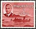 Grand Port on a 1950 stamp of Mauritius.
See also
| Wikimedia Commons has media related to Grand Port District. |
References
- ↑ http://localgovernment.gov.mu/English/Local%20Authorities/Pages/Municipal-and-District-Councils-in-Mauritius.aspx
- 1 2 3 Ministry of Finance & Economic Development (2016). "ANNUAL DIGEST OF STATISTICS 2015" (PDF). August. Government of Mauritius: 19. Retrieved 23 December 2016.
- ↑ Statistic office of Mauritius (2011). "Housing and population Census 2011" (PDF). Government of Mauritius. Retrieved 6 September 2012.
- ↑ http://www.lemauricien.com/article/municipales-toilettage-des-registres-d%E2%80%99%C3%A9lecteurs
- ↑ "Table D2 - Resident population by geographical location, age and sex" (PDF). 2011 housing and population census. Statistics Mauritius. p. 51. Archived from the original (PDF) on 16 October 2013. .
- 1 2 "Archived copy" (PDF). Archived from the original (PDF) on 3 March 2016. Retrieved 19 September 2016.
Places adjacent to Grand Port District | ||||||||||
|---|---|---|---|---|---|---|---|---|---|---|
| ||||||||||
| Subdivisions |
| .svg.png) | ||||||||||||
|---|---|---|---|---|---|---|---|---|---|---|---|---|---|---|
| Politics | ||||||||||||||
| Economy | ||||||||||||||
| Society |
| |||||||||||||