Plaines Wilhems District
| Plaines Wilhems | |
|---|---|
| District | |
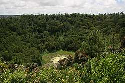 Trou aux Cerfs volcano | |
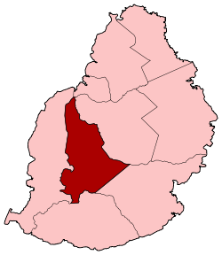 Map of Mauritius island with Plaines Wilhems District highlighted | |
| Coordinates: 20°18′S 57°29′E / 20.300°S 57.483°ECoordinates: 20°18′S 57°29′E / 20.300°S 57.483°E | |
| Country |
|
| Government | |
| Area | |
| • Total | 203.3 km2 (78.5 sq mi) |
| Population (2015)[1] | |
| • Total | 368,621 |
| • Rank | 1st in Mauritius |
| • Density | 1,800/km2 (4,700/sq mi) |
| Time zone | UTC+4 (MUT) |
| ISO 3166 code | MU-PW (Plaines Wilhems) |
Plaines Wilhems (Creole pronunciation: [plɛn wilɛmz]) is a district of Mauritius. It is the most populous district, with its population estimated at 368,621 as of 31 December 2015.[1] The district is mainly urban; it consists of four towns, the village of Midlands and part of two other villages. The Plaines Wilhems district does not have a District Council; it has four Municipal Town Councils. The towns are Beau-Bassin Rose-Hill, Curepipe, Quatre Bornes and Vacoas-Phoenix. The villages are Midlands, Cascavelle (East - West in Rivière Noire district) and Moka (West- East in Moka district).[2][3] The district was named after Wilhem Leicknig. Of Prussian origin, he settled on the island of Mauritius, then known as Isle de France, in 1721.[4]
Education
Secondary schools in the district include:
- Lycée La Bourdonnais - Curepipe[5]
- Lycée des Mascareignes- Moka
- Royal College Curepipe - Curepipe
- Royal College Port-Louis - Port-Louis
- Queen Elizabeth College - Beau-Bassin Rose-Hill
See also
| Wikimedia Commons has media related to Plaines Wilhems District. |
References
- 1 2 Ministry of Finance & Economic Development (2016). "ANNUAL DIGEST OF STATISTICS 2015" (PDF). August. Government of Mauritius: 22. Retrieved 23 December 2016.
- ↑ Ministry of Local Government and Outer Islands. "Local Government Act 2011" (PDF). Government of Mauritius. Archived from the original (PDF) on 14 November 2012. Retrieved 28 November 2012.
- ↑ Statistic office of Mauritius (2011). "Housing and population Census 2011" (PDF). Government of Mauritius. Archived from the original (PDF) on 21 October 2013. Retrieved 28 November 2012.
- ↑ "History of Quatre Bornes". Municipal Council of Quatre Bornes. Archived from the original on 9 August 2012. Retrieved 30 November 2012.
- ↑ Home page. Lycée La Bourdonnais. Retrieved on May 4, 2015. "Rue Rochecouste - Forest Side - Curepipe - MAURICE"
Places adjacent to Plaines Wilhems District | ||||||||||
|---|---|---|---|---|---|---|---|---|---|---|
| ||||||||||
| Subdivisions |
| .svg.png) | ||||||||||||
|---|---|---|---|---|---|---|---|---|---|---|---|---|---|---|
| Politics | ||||||||||||||
| Economy | ||||||||||||||
| Society |
| |||||||||||||