Port Louis District
| Port Louis | |
|---|---|
| District | |
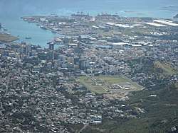 Port Louis and its harbour | |
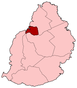 Map of Mauritius island with Port Louis District highlighted | |
| Coordinates: 20°10′S 57°31′E / 20.167°S 57.517°ECoordinates: 20°10′S 57°31′E / 20.167°S 57.517°E | |
| Country |
|
| Government[1] | |
| • Type | City Council |
| • Lord Mayor | Mr. Hoseenally Aslam Adam |
| • Deputy Lord Mayor | Mrs. Chukowry M. Christianne Dorinne |
| Area | |
| • Total | 42.7 km2 (16.5 sq mi) |
| Population (2015)[2] | |
| • Total | 119,706 |
| • Rank | 4th in Mauritius |
| • Density | 2,800/km2 (7,300/sq mi) |
| Time zone | UTC+4 (MUT) |
| ISO 3166 code | MU-PL (Port Louis) |
Port Louis is a district of Mauritius, located in the north west of the island, it is the smallest district and has the highest population density. The district is wholly covered by Port Louis, the capital of the country. Port Louis district has an area of 42.7 km2 and the population estimate was at 119,706 as at 31 December 2015.[2]
Places of interest
The district hosts the Aapravasi Ghat, a UNESCO World Heritage Site since 2006.
References
- ↑ "Archived copy". Archived from the original on 4 April 2014. Retrieved 8 March 2014.
- 1 2 Ministry of Finance & Economic Development (2016). "ANNUAL DIGEST OF STATISTICS 2015" (PDF). August. Government of Mauritius: 22. Retrieved 23 December 2016.
Places adjacent to Port Louis District | ||||||||||
|---|---|---|---|---|---|---|---|---|---|---|
| ||||||||||
| Subdivisions |
| .svg.png) | ||||||||||||
|---|---|---|---|---|---|---|---|---|---|---|---|---|---|---|
| Politics | ||||||||||||||
| Economy | ||||||||||||||
| Society |
| |||||||||||||
This article is issued from
Wikipedia.
The text is licensed under Creative Commons - Attribution - Sharealike.
Additional terms may apply for the media files.