Grand Manan Parish, New Brunswick
| Grand Manan | |
|---|---|
| Parish | |
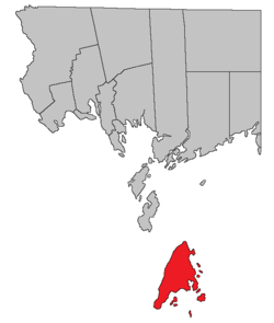 Location within Charlotte County. | |
| Country |
|
| Province |
|
| County | Charlotte County |
| Established | 1816 |
| Area[1] | |
| • Land | 6.20 km2 (2.39 sq mi) |
| Population (2011)[1] | |
| • Total | 162 |
| • Density | 26.1/km2 (68/sq mi) |
| • Pop 2006-2011 |
|
| • Dwellings | 100 |
| Time zone | UTC-4 (AST) |
| • Summer (DST) | UTC-3 (ADT) |
Grand Manan is a Canadian parish created in 1816 from West Isles Parish which includes several islands in Charlotte County, New Brunswick.[2] The islands are part of the Fundy Islands.
Delineation
Grand Manan Parish is defined in the Territorial Division Act[3] as:
- Being the island so named and all the islands to the south and east thereof.
Bodies of water & islands
This is a list of rivers, lakes, streams, creeks, marshes and Islands that are at least partially in this parish
|
|
|
Communities
Parish population total does not include incorporated municipalities (in bold).
Grand Manan Island Communities
|
|
Demographics
Population
| Canada census – Grand Manan Parish, New Brunswick community profile | |||
|---|---|---|---|
| 2011 | 2006 | ||
| Population: | 162 (-14.7% from 2006) | 190 (+1.1% from 2001) | |
| Land area: | 6.20 km2 (2.39 sq mi) | 6.20 km2 (2.39 sq mi) | |
| Population density: | 26.1/km2 (68/sq mi) | 30.6/km2 (79/sq mi) | |
| Median age: | 49.0 (M: 45.5, F: 52.0) | 39.5 (M: 35.7, F: 42.5) | |
| Total private dwellings: | 100 | 107 | |
| Median household income: | $.N/A | $.N/A | |
| Notes: Income data – References: 2011[1] 2006[4] earlier[5] | |||
| Historical Census Data - Grand Manan Parish, New Brunswick[6] | ||||||||||||||||||||||||||
|---|---|---|---|---|---|---|---|---|---|---|---|---|---|---|---|---|---|---|---|---|---|---|---|---|---|---|
|
|
| ||||||||||||||||||||||||
Language
| Canada Census Mother Tongue - Grand Manan Parish, New Brunswick[6] | ||||||||||||||||||
|---|---|---|---|---|---|---|---|---|---|---|---|---|---|---|---|---|---|---|
| Census | Total | English |
French |
English & French |
Other | |||||||||||||
| Year | Responses | Count | Trend | Pop % | Count | Trend | Pop % | Count | Trend | Pop % | Count | Trend | Pop % | |||||
2011 |
170 |
160 | 94.12% | 5 | 2.94% | 0 | 0.00% | 5 | 2.94% | |||||||||
2006 |
195 |
195 | 100.00% | 0 | 0.00% | 0 | 0.00% | 0 | 0.00% | |||||||||
2001 |
190 |
180 | 94.74% | 0 | 0.00% | 0 | 0.00% | 10 | 5.26% | |||||||||
1996 |
130 |
130 | n/a | 100.00% | 0 | n/a | 0.00% | 0 | n/a | 0.00% | 0 | n/a | 0.00% | |||||
Access Routes
Highways and numbered routes that run through the parish, including external routes that start or finish at the parish limits:[7]
|
|
|
|
See also
References
- 1 2 3 "2011 Community Profiles". Canada 2011 Census. Statistics Canada. July 5, 2013. Retrieved 2014-03-15.
- ↑ New Brunswick Provincial Archives - Grand Manan Parish
- ↑ "Territorial Division Act (R.S.N.B. 1973, c. T-3)". Government of New Brunswick website. Retrieved 23 August 2016.
- ↑ "2006 Community Profiles". Canada 2006 Census. Statistics Canada. March 30, 2011. Retrieved 2014-03-15.
- ↑ "2001 Community Profiles". Canada 2001 Census. Statistics Canada. February 17, 2012.
- 1 2 Statistics Canada: 1996, 2001, 2006, 2011 census
- ↑ Atlantic Canada Back Road Atlas ISBN 978-1-55368-618-7 Pages 4, 12
Places adjacent to Grand Manan Parish, New Brunswick | |
|---|---|
| Subdivisions | |
|---|---|
| Cities | |
| Counties | |
| |
Coordinates: 44°40′58″N 66°47′17″W / 44.682813°N 66.787949°W
This article is issued from
Wikipedia.
The text is licensed under Creative Commons - Attribution - Sharealike.
Additional terms may apply for the media files.