Grade I listed buildings in Monmouthshire

This is a list of the 53 Grade I listed buildings in Monmouthshire, Wales.[1]
In the United Kingdom, the term "listed building" refers to a building or other structure officially designated as being of special architectural, historical or cultural significance. These buildings are in three grades: Grade I consists of buildings of outstanding architectural or historical interest. Listing was begun by a provision in the Town and Country Planning Act 1947. Once listed, strict limitations are imposed on the modifications allowed to a building's structure or fittings. In Wales,[2] the authority for listing under the Planning (Listed Buildings and Conservation Areas) Act 1990[3] rests with Cadw.
The Grade I listed buildings in Monmouthshire comprise twenty-six churches, including a priory and an abbey, eight castles, seven houses, two bridges, a barn, a cross, a farm, a folly, a gatehouse, an hotel, a municipal building, a stables, and two elements of town walls.
Buildings
| Name | Location | Date Listed | Grid Ref.[note 1] Geo-coordinates |
Function | Notes | HB No[note 2] | Image |
|---|---|---|---|---|---|---|---|
| Tintern Abbey | Tintern | 29 September 2000 | SO5329100037 51°41′50″N 2°40′38″W / 51.69715140172°N 2.6772244447268°W |
Church | In a prominent position on the right bank of the river Wye on the east side of the A466.[4] | 24037 | 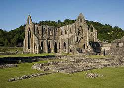 |
| Abbey Hotel | Llanthony | 1 September 1956 | SO2883227873 51°56′41″N 3°02′12″W / 51.944808861401°N 3.0367936443754°W |
Commercial | Built into the west range of Llanthony Priory. | 1940 | 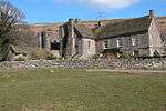 |
| Abergavenny Castle | Abergavenny | 5 July 1952 | SO2994413962 51°49′12″N 3°01′04″W / 51.819898203107°N 3.0177896854119°W |
Castle | Situated W off the main road on the southern approach to the town centre. | 2376 | 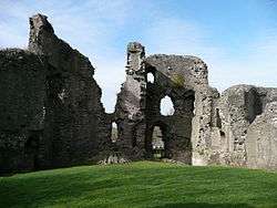 |
| Court Farm Barn | Llanthony | 1 September 1956 | SO2870227868 51°56′41″N 3°02′19″W / 51.944747235926°N 3.0386835615742°W |
Barn | On the west side of the Llanthony Priory precinct about 110m from the Priory ruins. | 1941 | 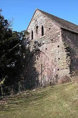 |
| St Aeddan's Church | Bettws Newydd | 1 September 1956 | SO3622305874 51°44′53″N 2°55′31″W / 51.747941854858°N 2.9252175906742°W |
Church | Situated at SE end of village, approached by lane running E just N of Bettws Lodge. | 1962 | 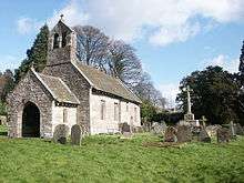 |
| Caldicot Castle | Caldicot | 10 June 1953 | ST4867988516 51°35′35″N 2°44′32″W / 51.59316838225°N 2.7422545221732°W |
Castle | About 300m east of the Church of St Mary and about 700m east of Caldicot. | 2006 | 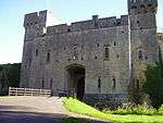 |
| Castle House | Usk | 16 February 1953 | SO3775301088 51°42′18″N 2°54′08″W / 51.705088232202°N 2.902201314861°W |
House | Situated on the hillside a little NE of Usk town centre and below the Castle. | 2128 | 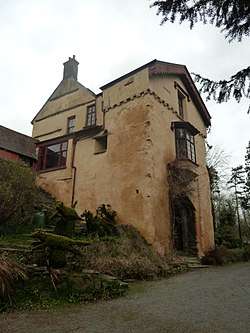 |
| Chepstow Castle | Chepstow | 6 December 1950 | ST5333094113 51°38′38″N 2°40′33″W / 51.64389456027°N 2.6758667834541°W |
Castle | In a commanding position on the W bank of the River Wye. Modern access from Bridge Street. | 2475 | 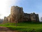 |
| Church of St Peter, St Paul and St John | Llantrisant | 18 November 1980 | ST3912196924 51°40′04″N 2°52′54″W / 51.667803883061°N 2.8816793569441°W |
Church | Situated in centre of Llantrissent village. | 2718 | 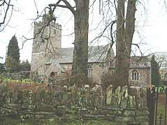 |
| Church of St Bridget | Skenfrith | 19 November 1953 | SO4560920340 51°52′44″N 2°47′30″W / 51.878984899316°N 2.7915523126198°W |
Church | situated towards the N end of Skenfrith village and approximately 100m NW of Skenfrith Castle (Grade II*), with which it forms part of a very fine group. | 2082 | 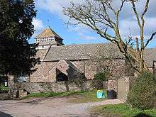 |
| Church of St Cadoc | Llangattock Lingoed | 1 September 1956 | SO3615220064 51°52′32″N 2°55′44″W / 51.87549890715°N 2.9288655122272°W |
Church | In a sloping churchyard, in the centre of Llangattock Lingoed. | 1955 | 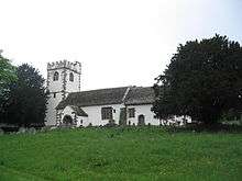 |
| Church of St David | Llangeview | 18 November 1980 | SO3968300694 51°42′06″N 2°52′27″W / 51.701757384859°N 2.8742069225504°W |
Church | Situated in rounded churchyard overlooking A 449 Usk exit, reached via lane running S from B4235 just E of bridge over A449. | 2711 | 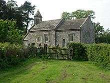 |
| Church of St David | Llanthony | 1 September 1956 | SO2884927820 51°56′40″N 3°02′12″W / 51.94433°N 3.03653°W |
Church | 50m south of the Priory buildings at Llanthony. | 1938 | 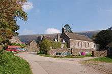 |
| Church of St Jerome | Llangwm | 19 August 1955 | SO4329000557 51°42′03″N 2°49′19″W / 51.700902675144°N 2.821996356783°W |
Church | Situated some 500m E of Llangwm Isaf church, in isolated site at end of lane. | 2028 |  |
| Church of St John | Llandenny | 27 November 1953 | SO4151203923 51°43′52″N 2°50′54″W / 51.730980562993°N 2.8482871471469°W |
Church | Situated in the centre of the village of Llandenny. The church is in an elevated position within an enclosed churchyard. | 17425 | 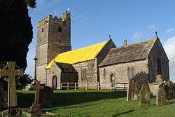 |
| Church of St Martin | Cwmyoy | 1 September 1956 | SO2990523354 51°54′16″N 3°01′13″W / 51.904322404237°N 3.0202641676575°W |
Church | In the centre of Cwmyoy village on the east slope of the Vale of Ewyas. It stands in a churchyard with a fine collection of well cut memorials. | 1933 |  |
| Church of St Mary | Abergavenny | 5 July 1952 | SO3010114136 51°49′17″N 3°00′56″W / 51.821482084132°N 3.0155474763321°W |
Church | Key building in the group of historic buildings close to the main commercial centre of Abergavenny. | 2373 |  |
| Church of St Mary | Caldicot | 19 August 1955 | ST4831688629 51°35′39″N 2°44′51″W / 51.59415°N 2.74751°W |
Church | About 400m north east of the centre of Caldicot village. | 2019 | 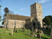 |
| Church of St Mary | Chepstow | 6 December 1950 | ST5359493973 51°38′34″N 2°40′19″W / 51.642657781077°N 2.6720331822535°W |
Church | At the end of the street within a churchyard crossed by a walkway to Lower Church Street. | 2594 |  |
| Church of St Mary the Virgin | Llanfair Kilgeddin | 1 September 1956 | SO3558708684 51°46′23″N 2°56′06″W / 51.773130426428°N 2.9349505372968°W |
Church | Close to the river Usk 1.5km NE of Pant-y-goitre.. | 2782 | 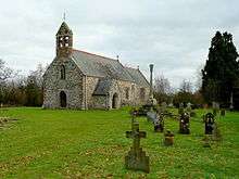 |
| Church of St Mary | Magor | 3 January 1963 | ST4252986980 51°34′44″N 2°49′51″W / 51.578763937612°N 2.8307725200588°W |
Church | Situated in the centre of the village and reached off Magor Square. | 2928 | 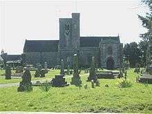 |
| Church of St Mary | Portskewett | 19 August 1955 | ST4988888107 51°35′23″N 2°43′29″W / 51.589600343769°N 2.7247447545583°W |
Church | In the centre of Portskewett village at the junction of Main Road and Sudbrook Road. | 2044 | 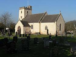 |
| Church of St Michael and All Angels | Gwernesney | 18 November 1980 | SO4148901805 51°42′43″N 2°50′54″W / 51.711937074281°N 2.8482636256591°W |
Church | Situated some 2 km ENE of Usk junction of A449, just N of B4235. | 2715 |  |
| Church of St Nicholas | Grosmont | 1 September 1956 | SO4047624300 51°54′51″N 2°52′00″W / 51.914059071955°N 2.8667958972657°W |
Church | In the centre of Grosmont in a large churchyard. | 1947 |  |
| Church of St Nicholas | Trellech | 19 November 1953 | SO5004305486 51°44′45″N 2°43′30″W / 51.745859624791°N 2.7249983592773°W |
Church | Prominently sited in the centre of Trellech village. | 2106 |  |
| Church of St Teilo | Llantilio Crossenny | 19 November 1953 | SO3988814983 51°49′49″N 2°52′25″W / 51.830237524744°N 2.8737181568702°W |
Church | Situated in a gently sloping churchyard in the centre of Llantilio Crossenny. | 2073 | 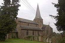 |
| Church of St Teilo | Llantilio Pertholey | 1 September 1956 | SO3115216336 51°50′29″N 3°00′03″W / 51.841389885889°N 3.0007398277434°W |
Church | Just off the old Hereford road about 3km north of Abergavenny. | 2002 | 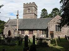 |
| Church of St Tewdric | Mathern | 19 August 1955 | ST5231390881 51°36′53″N 2°41′24″W / 51.61475139212°N 2.6901218736737°W |
Church | In the centre of Mathern village. | 2040 | 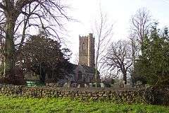 |
| Church of St Tysoi | Llansoy | 19 August 1955 | SO4421902396 51°43′03″N 2°48′32″W / 51.717529038817°N 2.8088501385971°W |
Church | Situated at S end of Llansoy village about 250m S of junction with main road. | 2029 | 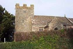 |
| Clytha Castle | Llanarth | 1 September 1956 | SO3639008390 51°46′14″N 2°55′24″W / 51.770579431288°N 2.923260277483°W |
Folly | Situated on hillside S of Clytha Park off old A40 some 300m E of gates to Clytha Park. | 1968 | 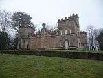 |
| Clytha Park | Llanarth | 1 September 1956 | SO3667109025 51°46′35″N 2°55′09″W / 51.776319928071°N 2.9193045353085°W |
House | Situated in landscaped park N of old A40 reached via drive from entrance opposite junction with road to Bettws Newydd. | 1966 | 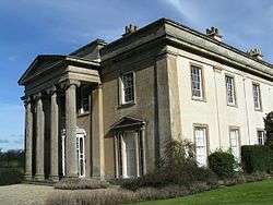 |
| Cross at Croes Lwyd | Raglan | 31 January 2001 | SO4005306992 51°45′30″N 2°52′12″W / 51.758416527154°N 2.8699402141797°W |
Cross | Situated on S side of Broom Lane about 400m E of Broom House, at the bottom of the garden at Whitecross Cottage. | 24716 | 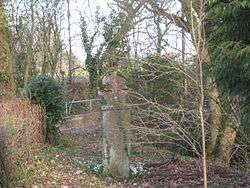 |
| Great Castle House | Monmouth | 15 August 1974 | SO5070912915 51°48′46″N 2°42′59″W / 51.812707845338°N 2.7164100024564°W |
House | Situated in the castle enclosure at the highest point of the town and just north of the town square. | 2217 | 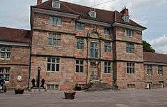 |
| Grosmont Castle | Grosmont | 1 September 1956 | SO4053224454 51°54′56″N 2°51′58″W / 51.915449494561°N 2.8660084897158°W |
Castle | On a flat elevated plateau, some 100m NW of Grosmont village, approached along a narrow lane from the main street. | 1949 |  |
| Llanthony Priory | Llanthony | 1 September 1956 | SO2885427872 51°56′41″N 3°02′11″W / 51.944802691704°N 3.0364734290307°W |
Church | In Llanthony village in the Vale of Eywas. | 1939 |  |
| Llanvihangel Court | Llanvihangel Crucorney | 5 June 1952 | SO3278120411 51°52′42″N 2°58′40″W / 51.878221343415°N 2.9778927642542°W |
House | In Llanvihangel Crucorney about 400m south east of the Church of St Michael. | 1919 | 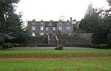 |
| Llwyn-celyn Farmhouse | Llanvihangel Crucorney | 1 September 1956 | SO3095021807 51°53′26″N 3°00′17″W / 51.890546478865°N 3.0047669592616°W |
Farmhouse | On a knoll on the west side of Stanton about 1.5km north west of Llanvihangel Crucorney. | 1937 |  |
| Mathern Palace | Mathern | 10 June 1953 | ST5229090821 51°36′51″N 2°41′26″W / 51.614210000776°N 2.6904458376599°W |
House | In the centre of Mathern village about 50m south west of the Church of St Tewdric. | 2007 | 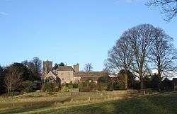 |
| Monmouth Castle | Monmouth | 15 August 1974 | SO5067512872 51°48′44″N 2°43′01″W / 51.812318256955°N 2.716897019083°W |
Castle | Situated on the east bank of the river Monnow at the highest point of the town and just north of the town square. | 2216 | 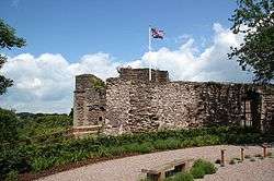 |
| Monnow Bridge | Monmouth | 15 August 1974 | SO5046012508 51°48′32″N 2°43′12″W / 51.809026739108°N 2.7199632928636°W |
Bridge | At the entrance to Monmouth's principal commercial street which leads up the hill to the town square from the south-west. | 2218 |  |
| Pen-y-Clawdd Court | Llanvihangel Crucorney | 5 June 1952 | SO3103020099 51°52′31″N 3°00′12″W / 51.875202368259°N 3.0032627120055°W |
House | About 1500m south west of the Church of St Michael, Llanvihangel Crucorney approached by a lane from the small settlement round the old Llanvihangel station. | 1926 |  |
| Penallt Old Church | Penallt | 19 November 1953 | SO5219810732 51°47′36″N 2°41′40″W / 51.79321162371°N 2.6945109680669°W |
Church | In the very northernmost corner of Trellech Community only about 1000m south of Monmouth, on the (B4239) at the junction by High Glanau. | 2104 | 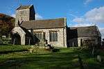 |
| Port Wall | Chepstow | 24 March 1975 | ST5325993947 51°38′33″N 2°40′37″W / 51.642396207326°N 2.676870551066°W |
Walls, railings, gates | Extending from near Chepstow Castle, uphill to the town gate and crossing to the quarry above the station. | 2477 | 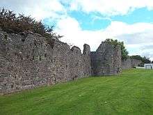 |
| St Mary's Priory Church | Usk | 4 January 1974 | SO3789200811 51°42′09″N 2°54′01″W / 51.702613430887°N 2.9001406321098°W |
Church | A town centre church, just south of the main thoroughfare with large walled churchyard. | 2123 | 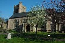 |
| Priory Gatehouse | Usk | 16 February 1953 | SO3783600795 51°42′09″N 2°54′03″W / 51.702463376228°N 2.9009480163587°W |
Gatehouse | At right angles to the churchyard entrance, on a corner site, facing up Priory Street to Twyn Square. | 2126 | 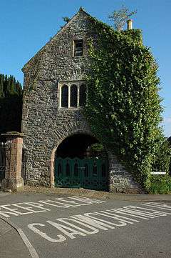 |
| Raglan Castle | Raglan | 19 November 1953 | SO4143308324 51°46′14″N 2°51′01″W / 51.770537620941°N 2.8501736636801°W |
Castle | Magnificently sited 0.25km N of Raglan and reached by private drive from the A 40. | 2101 | 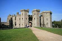 |
| Old Wye Bridge | Chepstow | 24 March 1975 | ST5361094359 51°38′46″N 2°40′19″W / 51.646129480673°N 2.6718532886353°W |
Bridge | Continuing the line of Bridge Street. Aligned almost due north/south, crossing a bend in the River Wye, here the boundary between Wales and England. The N part of the bridge is in England. | 2479 | 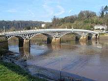 |
| Shire Hall | Monmouth | 27 June 1952 | SO5078012837 51°48′43″N 2°42′55″W / 51.812012876784°N 2.7153690759584°W |
Shire Hall | In the town square in the centre of Monmouth with a cobbled area to the front and sides spreading as far as the line of the road and including the statue of CS Rolls. | 2228 |  |
| Llanvihangel Court Stable Block | Llanvihangel Crucorney | 29 January 1998 | SO3279420362 51°52′40″N 2°58′40″W / 51.877782425112°N 2.9776943871555°W |
Stables | About 30m south of Llanvihangel Court | 19288 |  |
| Town Gate | Chepstow | 12 June 1950 | ST5327993793 51°38′28″N 2°40′36″W / 51.641013320263°N 2.6765609328788°W |
Walls, railings, gates | Standing at the main entrance to the fortified town between Moor Street outside the gate to W and High Street within walls to E. | 2476 | 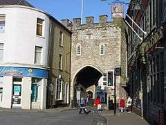 |
| Treowen | Mitchel Troy | 5 January 1952 | SO4615311109 51°47′46″N 2°46′56″W / 51.796050279369°N 2.7822105369036°W |
House | About 4.5km WSW of Monmouth and 1km NNE of Dingestow church, prominently situated amidst its own parkland just N of the road between Dingestow and Wonastow. | 2065 | 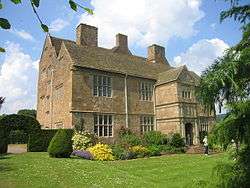 |
| Usk Castle | Usk | 16 February 1953 | SO3767701089 51°42′18″N 2°54′12″W / 51.705088767691°N 2.9033011675682°W |
Castle | On a spur on the hillside a short distance NE of the town. | 2127 | 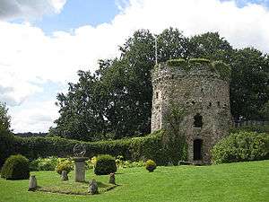 |
| White Castle | Llantilio Crossenny | 19 November 1953 | SO3795616754 51°50′45″N 2°54′07″W / 51.845946783581°N 2.9020686900332°W |
Castle | Sited overlooking Llanvetherine, some 3km NW of village of Llantilio Crossenny. | 2079 | 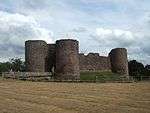 |
See also
- Listed buildings in Wales
- Grade I listed buildings in Herefordshire
- Grade I listed buildings in Forest of Dean
- Grade I listed buildings in Newport
- Grade I listed buildings in Torfaen
- Grade II* listed buildings in Blaenau Gwent – there are currently no Grade I listed buildings in Blaenau Gwent
- Grade I listed buildings in Powys
- Grade II* listed buildings in Monmouthshire
- Scheduled Monuments in Monmouthshire
Notes
- ↑ Sometimes known as OSGB36, the grid reference is based on the British national grid reference system used by the Ordnance Survey.
- ↑ The "HB Number" is a unique number assigned to each listed building by Cadw.
References
| Wikimedia Commons has media related to Grade I listed buildings in Monmouthshire. |
- ↑ Stuff, Good. "Grade I Listed Buildings in Monmouthshire". www.britishlistedbuildings.co.uk.
- ↑ "Coflein". online database of RCAHMW. Royal Commission on the Ancient and Historical Monuments of Wales. Retrieved 28 November 2016.
- ↑ "Planning (Listed Buildings and Conservation Areas) Act 1990". The National Archives. Retrieved 18 June 2013.
- ↑ "Listed Buildings - Full Report - HeritageBill Cadw Assets - Reports". cadwpublic-api.azurewebsites.net.