Cross at Croes Llwyd Farm, Raglan
| Cross at Croes Llwyd Farm, Raglan | |
|---|---|
 "a very rare survival of a medieval boundary marker" | |
| Type | Cross |
| Location | Raglan, Monmouthshire |
| Coordinates | 51°43′45″N 2°44′46″W / 51.7292°N 2.7462°WCoordinates: 51°43′45″N 2°44′46″W / 51.7292°N 2.7462°W |
| Built | late 16th century |
| Architectural style(s) | Vernacular |
| Governing body | Privately owned |
Listed Building – Grade I | |
| Official name: Cross at Croes Lwyd | |
| Designated | 31 January 2001 |
| Reference no. | 24716 |
| Official name: Cross at Croes Lwyd Farm | |
| Reference no. | MM156 |
 Location of Cross at Croes Llwyd Farm, Raglan in Monmouthshire | |
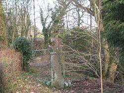
The Cross at Croes Llwyd Farm, Raglan, Monmouthshire is a medieval cross which indicated a boundary of the Lordship of Raglan. As a rare medieval survival, it is both a Grade I listed structure and a Scheduled monument.
History and description
The cross stands on Broom Lane, to the east of Broom House, off the Raglan to Usk road.[1] It is 1.9 metres (6.2 ft) high, with an octagonal shaft.[2] The Monmouthshire antiquarian Sir Joseph Bradney described it as a "singularly well-preserved stone, the head and shaft being hewn out of the same piece."[3] The cross was the subject of Article 452 in the series Monmouthshire Sketchbook by the author and artist Fred Hando for the South Wales Argus between 1922 and 1970. Hando wrote that the cross was one of the only two remaining crosses in Monmouthshire, from a total of seventy-nine, which had survived with its head intact following the "Puritan folly of 1643."[4] He described its name, the "White Cross", as deriving from its whitewashed appearance but suggested "the appropriate name should be Grey Cross"[4] and that the cross was "at least five centuries" old.[4] The cross is a Grade I listed structure[5] and a scheduled monument.[6]
The cross appears to have had a dual purpose, as a preaching cross and as a boundary marker for the delineation of the medieval Lordship of Raglan.[5] Bradney records the mention of the cross in the grant of lands to William Herbert, "...and from this directly to a cross called Crosse Lloyd".[7] It is thought that the cross was moved, in about 1870, from a possible prior location at map reference SO40390659 (N 51.754813, W 2.8649842).[2]
Notes
- ↑ Stuff, Good. "Cross at Croes Lwyd, Raglan, Monmouthshire". www.britishlistedbuildings.co.uk.
- 1 2 "CROES LLWYD – Coflein". www.coflein.gov.uk.
- ↑ Bradney 1992, p. 2.
- 1 2 3 Hando 1961, p. unknown.
- 1 2 "Listed Buildings – Full Report – HeritageBill Cadw Assets – Reports". cadwpublic-api.azurewebsites.net.
- ↑ "Scheduled Monument – Full Report – HeritageBill Cadw Assets – Reports". cadwpublic-api.azurewebsites.net.
- ↑ Bradney 1992, p. 8.
References
- Bradney, Joseph (1992). A History of Monmouthshire: The Hundred of Raglan, Volume 2 Part 1. Academy Books. ISBN 1-873361-15-7.
- Hando, Fred (1961). Monmouthshire Sketch Book. South Wales Argus.