Pen y Clawdd Castle
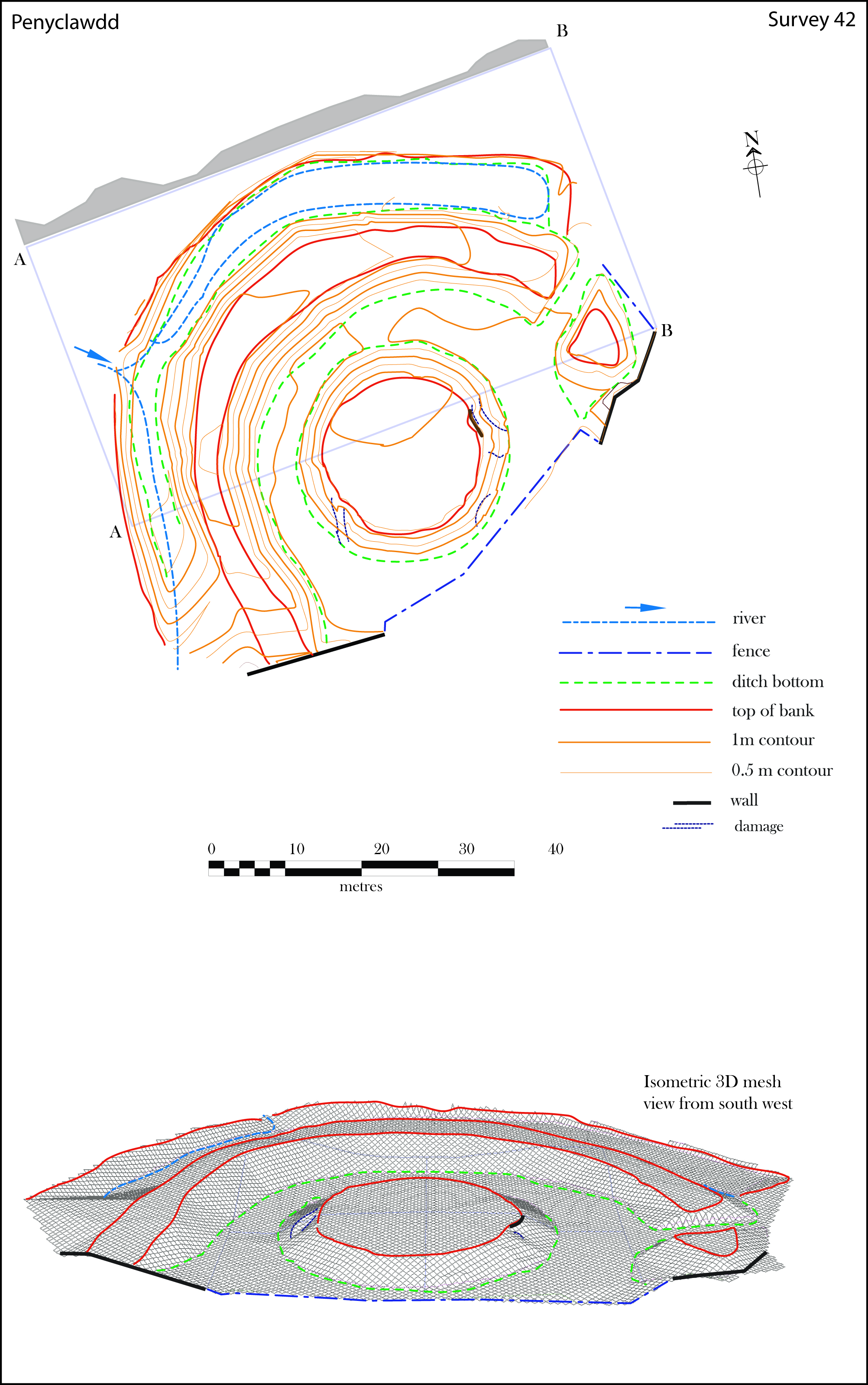
Pen y Clawdd Castle is a ditched mound with a double moat, roughly circular in shape, with a diameter of approximately 28m to 30m and about 2.4m high.[1] The castle is in Llanvihangel Crucorney, about five miles to the north of Abergavenny, Monmouthshire, in south east Wales and lies between the Usk and Monnow rivers.[2][3] The mound was designated a scheduled monument in 1950 and described as a defensive medieval motte.[4]
Surroundings
The castle mound is adjacent to Pen-y-Clawdd Court (a Grade I listed building),[5] a stable and cowshed with adjoining range, and a barn, all of which are Grade II listed buildings.[6][7] These buildings, along with the castle mound, are set in a roughly rectangular area about 150m by 135m.[1] This area is a possible location for the bailey part of the castle.[8] Some of the features of the mound may have been changed by landscaping around the later buildings.[1]
History
Very little is known of the exact origins of the castle, but it may have been built by Roger de Hastings during the 11th century, as one of a number of forts created after the Revolt of the Earls in 1075.[3] However, no contemporary evidence of occupation of the site exists up to 1349 when, for half a knight's fee, Walter de Kymbard held the site from Laurence de Hastings, 1st Earl of Pembroke, who was also Baron [A]Bergavenny.[2][9]
The adjacent Pen-y-Clawdd Court was probably built early in the 16th century and extended and remodelled early in the 17th century.[5] The farm buildings were added later; cowshed (early 18th century), barn (mid 18th century), and stable and range (early 19th century).[6][7]
Investigation and interpretation
The site was surveyed (topographic and geophysical), along with a number of other earthwork sites, between December 1999 and February 2001.[10] Excavations were carried out in 2002 and 2003.[11] The surveys and excavations suggested that there was a large rectangular masonry structure on the mound which suffered fire damage and partly collapsed. The stones may have been used when Pen-y-Clawdd Court was built.[12]
Phillips suggests that the site is a fortified house from a later period,[13] but may have been preceded by a motte and bailey.[12] Both Remfry and Phillips note that the position of the site below a hill is not a usual choice for a motte and bailey and find it "an awkward site to interpret" and "puzzling".[14][2] Salter classes the motte as a medieval fortified site rather than a castle.[15]
References
- 1 2 3 Wiles, J. (16 September 2002). "Pen-y-Clawdd Court, Castle Mound". National Monuments Record of Wales (NMRW). Royal Commission on the Ancient and Historical Monuments of Wales (RCAHMW). NPRN 306454. Retrieved 7 April 2016 – via coflein (online database of the NMRW).
- 1 2 3 Remfry, Paul Martin (2004). "Penyclawdd Castle". Anglo-Norman Castles. Retrieved 7 April 2016.
- 1 2 Thomas, Jeffrey L. (2009). "Pen y Clawdd Castle". Castles of Wales. Retrieved 7 April 2016.
- ↑ "Pen y Clawdd Castle Mound". National Monuments Record of Wales (NMRW). Cadw. 12 December 1950. Cadw Id: MM145. Missing or empty
|url=(help) - 1 2 "Pen-y-Clawdd Court". Statutory List of Buildings. Cadw. 29 January 1998 [Listed 1952]. Cadw Building ID: 1926. Retrieved 7 April 2016 – via Historic Wales.
- 1 2 "Stable and cowhouse ranges at Pen-y-Clawdd Court". Statutory List of Buildings. Cadw. 29 January 1998 [Listed 1989]. Cadw Building ID: 19252. Retrieved 7 April 2016 – via Historic Wales.
- 1 2 "Barn to south of Pen-y-Clawdd Court". Statutory List of Buildings. Cadw. 29 January 1998 [Listed 1989]. Cadw Building ID: 2824. Retrieved 7 April 2016 – via Historic Wales.
- ↑ "Pen-y-Clawdd Castle Mound". Historic Environment Record (HER). Glamorgan-Gwent Archaeological Trust (GGAT). PRN 01622g. Retrieved 8 April 2016 – via archwilio (online database of the four Welsh Archaeological Trusts).
- ↑ Phillips, Neil (2004). Earthwork Castles of Gwent and Ergyng AD 1050–1250 (PDF). Archaeology Data Service (Ph.D.). I. University of York. p. 297. Retrieved 8 April 2016.
- ↑ Phillips 2004, pp. 68–70.
- ↑ Phillips 2004, p. 70.
- 1 2 Phillips 2004, p. 298.
- ↑ Phillips 2004, p. 203.
- ↑ Phillips 2004, pp. 297–8.
- ↑ Salter, Mike (2002). "Other Medieval Fortified Sites in Gwent". Castles of Gwent, Glamorgan & Gower (2nd ed.). Malvern, Worcestershire: Folly Publications. p. 55. ISBN 1-871731-61-5. OCLC 54947157.