Devauden
Devauden
| |
|---|---|
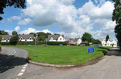 The village green at Devauden | |
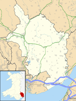 Devauden Devauden shown within Monmouthshire | |
| Population | 1,040 (2011) |
| OS grid reference | ST483990 |
| Principal area | |
| Ceremonial county | |
| Country | Wales |
| Sovereign state | United Kingdom |
| Post town | CHEPSTOW |
| Postcode district | NP16 |
| Dialling code | 01291 |
| Police | Gwent |
| Fire | South Wales |
| Ambulance | Welsh |
| EU Parliament | Wales |
| UK Parliament | |
| Welsh Assembly | |
Devauden (Welsh: Y Dyfawden) is a village and community in Monmouthshire, southeast Wales. It is located between Chepstow and Monmouth near the top of the Trellech ridge on the B4293 road. The community covers an area of 3,790 hectares (14.6 sq mi).[1]
History
There is evidence that an ancient ridgeway between Monmouth and the coast at Mathern passed through Devauden. Roman coins from the period of Antoninus Pius were found in the village in 1840.
Devauden was said in the Anglo-Saxon Chronicle to have been the place where the Britons were overwhelmed and defeated by the combined forces of the Anglo-Saxon monarchs, Æthelbald of Mercia and Cuthred of Wessex, in 743.[2] The name may be derived from the Welsh Ty'r ffawydden, or "house of the beech tree". Until the mid-20th century the village was often known as The Devauden.
Devauden and the nearby hamlet of Fedw or Veddw (from Welsh Y fedw, birch grove) were originally clusters of illicit cottages built as a base by woodcutters, mule drivers, quarrymen and labourers linked to the wireworks at Tintern and the Angiddy valley.[3] The village was historically part of the parish of Newchurch.
On 15 October 1739, John Wesley preached his first sermon in Wales on the village green at Devauden. He wrote in his journal: "Upon a pressing invitation, some time since received, I set out for Wales. About four in the afternoon I preached on a little green at the foot of the Devauden ... to three or four hundred plain people on "Christ our wisdom, righteousness, sanctification, and redemption." After sermon, one who I trust is an old disciple of Christ willingly received us into his house.."[4]
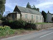
James Davies (1765–1849) was schoolmaster at Devauden for over 30 years during the early 19th century and was responsible for establishing a village school in 1815. In 1830 the school was converted into a chapel and a new schoolroom was built next door. Davies gained a strong local reputation for enduring personal hardship in order to help the poor in the community.[4] The school closed in 1986. The small parish church is dedicated to St. James.[5]
Demographics
Devauden's population was 1040, according to the 2011 census;[1] a 7.44% increase since the 968 people noted in 2001.[6]
The 2011 census showed 11.4% of the population could speak Welsh, a rise from 5.8% in 2001.[7]
Governance
An electoral ward in the same name exists. This ward stretches from Devauden to Llangwm. The total ward population taken at the 2011 census was 1,480.[8]
Chepstow Park Wood
Chepstow Park Wood, located immediately south of the village towards Itton, is an extensive area of mixed woodland owned and managed by the Forestry Commission,[9] popular with walkers. It was established as a hunting forest around 1280 by Roger Bigod, 5th Earl of Norfolk, the lord of Striguil or Chepstow Castle. It covers about 3,300 hectares, and was originally enclosed by a fence stretching 7.8 km. Around 1340, it was occupied and taken over by a band of outlaws led by William de Derneford and his son Robert. It was re-enclosed with a stone wall around 1630, and at the same time a stone lodge was built in the centre of the forest, with views back towards Chepstow, for the use of visitors to the forest.[10] Later, the wood became notorious as a haunt of highwaymen. Historically, the woodland lay within the parish of Newchurch East.[11]
Amenities
The Hood Memorial Hall was opened in 1953, funded by a local resident, Mrs. Hood, on land donated by Lady Curre.[12] The pub,[13] the Mason's Arms, dates from around 1800.
The village is located within the Wye Valley AONB. The recently created garden at Veddw House[14][15] is an increasingly popular visitor attraction.
References
- 1 2 "Area: Devauden (Parish)". Office for National Statistics. 30 January 2013. Retrieved 14 August 2015.
- ↑ KELLY'S DIRECTORY OF MONMOUTHSHIRE, 1901
- ↑ Villages | Wye Valley Area of Outstanding Natural Beauty (AONB)
- 1 2 History of Devauden, Monmouthshire Archived 2011-10-02 at the Wayback Machine.
- ↑ Photo of church
- ↑ "Area: Devauden (Parish)". Office for National Statistics. 18 November 2004. Retrieved 14 August 2015.
- ↑ "2011 Census results by Community". Welsh Language Commissioner. 2015. Retrieved 14 August 2015.
- ↑ "Ward population 2011". Retrieved 3 April 2015.
- ↑ Forestry Commission
- ↑ Rick Turner and Andy Johnson (eds.), Chepstow Castle - its history and buildings, 2006, ISBN 1-904396-52-6
- ↑ Vision of Britain
- ↑ Devauden village hall:: OS grid ST4898 :: Geograph British Isles - photograph every grid square!
- ↑ The Masons Arms:: OS grid ST4898 :: Geograph British Isles - photograph every grid square!
- ↑ "Veddw House gardens near Chepstow and places to stay". Archived from the original on 2008-01-25. Retrieved 2008-01-16.
- ↑ Review of Veddw House Gardens Archived 2008-10-10 at the Wayback Machine.