Llantilio Pertholey
Llantilio Pertholey
| |
|---|---|
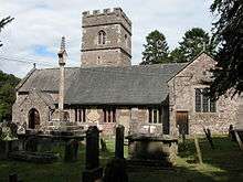 Church of St. Teilo, Llantilio Pertholey | |
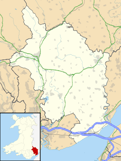 Llantilio Pertholey Llantilio Pertholey shown within Monmouthshire | |
| Population | 3,906 (2011)[1] |
| OS grid reference | SO312164 |
| Principal area | |
| Ceremonial county | |
| Country | Wales |
| Sovereign state | United Kingdom |
| Post town | ABERGAVENNY |
| Postcode district | NP7 |
| Dialling code | 01600 |
| Police | Gwent |
| Fire | South Wales |
| Ambulance | Welsh |
| EU Parliament | Wales |
| UK Parliament | |
Llantilio Pertholey (Welsh: Llandeilo Bertholau) is a small village and community (parish) in Monmouthshire, south east Wales. It is located 1.5 miles (2.4 km) to the north-east of the market town of Abergavenny, just off the A465 road to Hereford. The parish covers a large area beneath the Skirrid, an outlier of the Black Mountains; much of the parish lies within the easternmost part of the Brecon Beacons National Park.
Governance
The village falls in the 'Mardy' electoral ward. This ward stretches to the east. The total population taken at the 2011 census was 1,469.[2]
History and amenities
The 13th century medieval Church of St Teilo is named after a 6th-century Bishop of Llandaff who was canonised for his good works. The church is a fine example of a rural Welsh church with three chantry chapels dating from about 1350.
The hamlet also had a primary school, which moved to the nearby Mardy district of Abergavenny in 1991. A popular pub, The Mitre, opposite the church closed some years ago.
References
- ↑ "Parish population 2011". Retrieved 4 April 2015.
- ↑ "Mardy ward 2011". Retrieved 4 April 2015.
External links
| Wikimedia Commons has media related to Llantilio Pertholey. |
- St. Teilo's Church website
- Llantilio Pertholey Primary School
- Old photo of the church
- Recent photo of the church
- Kelly's Directory of Monmouthshire 1901
- Map sources for Llantilio Pertholey