Gordil Airport
| Gordil Airport | |||||||||||
|---|---|---|---|---|---|---|---|---|---|---|---|
| Summary | |||||||||||
| Airport type | Private | ||||||||||
| Serves | Gordil, Central African Republic | ||||||||||
| Location | Melle | ||||||||||
| Elevation AMSL | 1,427 ft / 435 m | ||||||||||
| Coordinates | 9°35′00″N 21°44′00″E / 9.58333°N 21.73333°ECoordinates: 9°35′00″N 21°44′00″E / 9.58333°N 21.73333°E | ||||||||||
| Map | |||||||||||
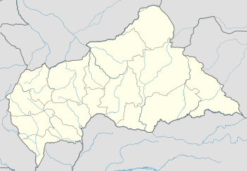 GDI Location of Gordil Airport in the Central African Republic | |||||||||||
| Runways | |||||||||||
| |||||||||||
Gordil Airport (IATA: GDI, ICAO: FEGL) is an airstrip serving Gordil, a village in the Vakaga prefecture of the Central African Republic. The airstrip is 5 kilometres (3.1 mi) southeast of Gordil alongside the RN8 road in the northern part of Manovo-Gounda St. Floris National Park.
The runway is unusable during the rainy season, and aircraft have to do steep departures and landings in order not to disturb the wildlife in the park. The east end of the runway overruns onto the RN8 road.
See also

- Transport in the Central African Republic
- List of airports in the Central African Republic
References
- ↑ Airport record for Melle Gourdil Airport at Landings.com. Retrieved 2013-08-25
- ↑ "Gordil Airport". Google Maps. Google. Retrieved 21 July 2018.
- ↑ Airport information for Gordil Airport at Great Circle Mapper.
External links
- OpenStreetMap - Gordil
- OurAirports - Gordil Airport
- FallingRain - Gordil Airport
- Accident history for Gordil Airport at Aviation Safety Network
This article is issued from
Wikipedia.
The text is licensed under Creative Commons - Attribution - Sharealike.
Additional terms may apply for the media files.