Geraldine, New Zealand
| Geraldine Heratini (Māori) | |
|---|---|
| Town | |
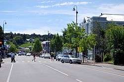 Talbot St (New Zealand State Highway 79) in Geraldine | |
 Geraldine | |
| Coordinates: 44°05′25″S 171°14′36″E / 44.09028°S 171.24333°ECoordinates: 44°05′25″S 171°14′36″E / 44.09028°S 171.24333°E | |
| Country |
|
| Region | Canterbury |
| Territorial authority | Timaru District |
| Population (2013)[] | |
| • Total | 2,301 |
| Time zone | UTC+12 (New Zealand Standard Time) |
| • Summer (DST) | UTC+13 (New Zealand Daylight Time) |
| Postcode | 7930 |
| Local iwi | Ngāi Tahu |
Geraldine or Heratini (Māori) is a town in the Canterbury Region in the South Island of New Zealand. It is about 140 km south of Christchurch, and inland from Timaru, which is 35 km to the south.
History
There is evidence of Māori travels through the Geraldine area and artifacts and carvings have been discovered in the nearby areas of Beautiful Valley, Gapes Valley and Kakahu.[1] The area was part of the continuous Canterbury Purchase or Kemp's Deed whereby over thirteen thousand acres was purchased by Henry Tacy Kemp on behalf of the Crown from Ngāi Tahu for £2,000 in 1848.[2] Following the purchase the colonial surveyor Charles Torlesse visited the region in 1849.[1] However, it wasn't until 1854 when Thomas Cass, the Chief Surveyor for the Canterbury region and Guise Brittan, Commissioner for Crown Lands, proposed a town site at Talbot Forest.[1] Following this Samuel Hewlings under the employment of the government as a surveyor, constructed a bark hut were the probably future site of a town would be.[1] In fact, a Tōtara tree planted to commemorate the birth of Hewlings daughter with his wife Nga Hei, still stands today opposite the police station where his nearby bark hut once stood. While Hewlings was indeed the first to person to live in Geraldine, his residence was not permanent and Alfred Cox and William du Moulin abet on the other side of the river in Raukapuka were the towns first permanent residence.[1] The town which up until 1857 was known as Talbot Forest was firstly named Fitzgerald in honor of James FitzGerald, the first Superintendent of the Canterbury Province. However, this was later changed to Geraldine though the exact reasoning for this is unknown.[1]
Growth in the township was slow at first with separate towns being constructed such as Healey Town in present day south Geraldine, Maslin Town between Kennedy and Hislop Street and the German settlement known as German Town on the Downs.[1] By 1862 most of the main streets had been named and sections surveyed and the area gazetted in 1867.[3] At this time timber milling and the numerous sheep runs in the area were the main sources of commerce.The town experienced significant growth during this period and as the timber ran out farming took over as the major source of income in the area.
Surroundings
Talbot Forest
Within walking distance of the town centre is Talbot Forest Scenic Reserve. Talbot Forest is the last remaining remnants of a vast native forest which covered the Geraldine and surrounding areas.[4] The reserve is home to an impressive variety of native hardwoods including Mataī, Kahikatea and Tōtara, including one estimated to be 800 years old.[5]
Native reserves
The Geraldine area is home to numerous native reserves within driving distance. These include Kakahu Bush Reserve, Orari Gorge Scenic Reserve, Peel Forest Park Scenic Reserve, Pioneer Park Conservation Area, Tenehaun Conservation Area and Waihi Gorge Scenic Reserve.
Education
Geraldine has two schools.
Geraldine Primary School[6] is a decile 8 state co-educational contributing[nb 1] school, with 331 students (as of August 2018).[7]
Geraldine High School (est 1963)[8] is a decile 8 state co-educational secondary school that provides for students years 7 through 13, with 570 students (as of August 2018).[7]km
Government
Local government
Geraldine became a Town District in 1884 operating out of the historic Town Board Office.[9] In 1904 Geraldine was constituted a borough.[3] Presently, Geraldine is part of the Timaru District Council led by current mayor Damon Odey. Geraldine is represented by a community board and a councilor.
Central government
The Geraldine Electorate was first formed in the 1875-1876 election but would be twice disestablished and subsequently reestablished in the following years before being abolished in the 1911 election. The electorate was represented by six Members of Parliament. The electorate split between the newly established Temuka Electorate, however, majority of the land went to the Ashburton Electorate. Following controversial boundary changes in 2008, saw the Aoraki Electorate abolished and Geraldine become part of the Waitaki electorate with its head office in Oamaru despite nearby towns such as Temuka, Orari and Ashburton joining the Timaru based Rangitata electorate.[10] Geraldine is currently part of the Waitaki electorate held by Jacqui Dean of the National Party.[11]
Entertainment and media
Movies are shown at the Historic Geraldine Cinema (est. 1924), located on Talbot St.[12] Geraldine's first radio station, Z100FM, operated in 1999-2000. This changed to Four Peaks FM in 2001. Just Country FM currently broadcasts from the town.[13]
Economy
Agricultural
The agricultural industry is at the heart of the local economy. While there has been a substantial increase in dairy farms in the region over the last twenty years, there are still large sectors involved in the cropping, deer, sheep and beef. Many small local businesses service the needs of the surrounding agricultural industry. Large agricultural processing facilities operate in the area include Fonterra's Clandeboye facility and Barkers of Geraldine as well as numerous smaller industrial operations.
Tourism
Geraldine is the gateway for many international and domestic tourists on their way from Christchurch down to the Mackenzie Country, the Southern Lakes District or the popular tourist destinations of Queenstown and Wanaka. There are numerous cafes, restaurants and shops which cater for tourists all year round. The town is also home to various tourist operators which showcase the local natural environment such as rafting, horse trekking and tours.
Events
Geraldine hosts the annual Geraldine Arts and Plants Festival which begun in 1988 and draws large crowds from all over the South Island.[14]
Historic buildings
The town is home to numerous heritage listed buildings which remain standing to this day:
- 137 Talbot Street
- Corner Shop (Talbot Street)
- Corner Shop Cottage (Talbot Street)
- Crown Hotel (Talbot Street)
- Geraldine Co-operative Cheese Factory (Pleasant Valley Road)
- Post Office (Talbot Street)
- St Mary's Church (Talbot Street)
- St Mary's Vicarage (Talbot Street)
- Town Board Office (Cox Street)
Notable people
- John Badcock, artist
- Thomas Buxton, politician
- Frederick Flatman, politician
- Jordan Luck, musician
- Hayden Paddon, rally driver
- William Postlethwaite, politician
- Annabel Ritchie, rower
- William Rolleston, politician
- Gus Spillane, former All Black
- Edward Wakefield, politician
- Peter Williams, broadcaster
Notes
- ↑ Years 1-6
References
- Reed, A. W. (2002). The Reed Dictionary of New Zealand Place Names. Auckland: Reed Books. ISBN 0-7900-0761-4.
- 1 2 3 4 5 6 7 Button, John (2006). Geraldine The First 150 Years. Timaru: Geraldine 150 Committee. ISBN 0-473-11092-X.
- ↑ "Kemp's Deed, 1848". Te Runanga o Ngai Tahu. 1997. Retrieved 22 August 2018.
- 1 2 McLintock, A.H. (1966). "'GERALDINE', from An Encyclopaedia of New Zealand". Te Ara - The Encyclopedia of New Zealand. Retrieved 22 August 2018.
- ↑ "Around and about Geraldine" (PDF). Department of Conservation. Retrieved 22 August 2018.
- ↑ "Talbot Forest Scenic Reserve Tracks". Department of Conservation. Retrieved 22 August 2018.
- ↑ "Geraldine Primary School". Retrieved 12 December 2013.
- 1 2 "Directory of Schools - as at 13 September 2018". New Zealand Ministry of Education. Retrieved 22 September 2018.
- ↑ "Geraldine High School". Retrieved 12 December 2013.
- ↑ "Town Board Office (Former)". Heritage New Zealand. 2018. Retrieved 22 August 2018.
- ↑ Chatterton, Tracey (13 September 2008). "Candidates Not Fazed by Electorate Split". The Timaru Herald. Retrieved 22 August 2018.
- ↑ "About Jacqui". National Party. Retrieved 22 August 2018.
- ↑ "Geraldine Cinema". Timaru District Library. Archived from the original on 16 December 2008. Retrieved 2010-01-28.
- ↑ "Radio Heritage Foundation". Radio Heritage Foundation. Retrieved 2010-01-28.
- ↑ Tatham, Helen (14 November 2014). "About 10,000 attend Geraldine Arts and Plants Festival". The Timaru Herald. Retrieved 22 August 2018.
External links
| Wikimedia Commons has media related to Geraldine, New Zealand. |