Garlin, Kentucky
| Garlin | |
|---|---|
| Unincorporated community | |
 Garlin Location within the state of Kentucky  Garlin Garlin (the US) | |
| Coordinates: 37°6′50″N 85°15′8″W / 37.11389°N 85.25222°WCoordinates: 37°6′50″N 85°15′8″W / 37.11389°N 85.25222°W | |
| Country | United States |
| State | Kentucky |
| County | Adair |
| Elevation | 892 ft (272 m) |
| Time zone | UTC-6 (Central (CST)) |
| • Summer (DST) | UTC-5 (CDT) |
| GNIS feature ID | 492704 |
Garlin is an unincorporated community in Adair County, Kentucky, United States. Its elevation is 892 feet (272 m).[1]
History
A post office was established in the community in 1903, and probably named for its first postmaster.[2]
References
- ↑ U.S. Geological Survey Geographic Names Information System: Garlin, Kentucky
- ↑ Rennick, Robert M. (1987). Kentucky Place Names. University Press of Kentucky. p. 113. Retrieved 2013-04-28.
Municipalities and communities of Adair County, Kentucky, United States | ||
|---|---|---|
| City | 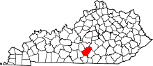 | |
| Unincorporated communities |
| |
| Footnotes | ‡This populated place also has portions in an adjacent county or counties. | |
This article is issued from
Wikipedia.
The text is licensed under Creative Commons - Attribution - Sharealike.
Additional terms may apply for the media files.