Pollution of the Ganges
Pollution of the Ganga (or Ganga), the largest river in India, poses significant threats to human health and the larger environment.[1] Severely polluted with human waste and industrial contaminants, the river provides water to about 40% of India's population across 11 states,[2] serving an estimated population of 500 million people or more, more than any other river in the world.[3][4]
Today, the Ganges is considered to be the fifth-most polluted river in the world.[5][6] Raghubir Singh, an Indian photographer, has noted that no one in India spoke of the Ganges as polluted until the late 1970s. However, pollution has been an old and continuous process in the river as by the time people were finally speaking of the Ganges as polluted, stretches of over six hundred kilometres were essentially ecologically dead zones.[7]
A number of initiatives have been undertaken to clean the river but failed to deliver desired results.[8] After getting elected, India's Prime minister Narendra Modi affirmed to work in cleaning the river and controlling pollution.[9] Subsequently, the Namami Gange project was announced by the government in the July 2014 budget.[10] An estimated Rs 2,958 Crores (US$460 million) have been spent till July 2016 in various efforts in cleaning up of the river.[11]
Causes
The main causes of water pollution in the Ganges river are the increase in the population density, various human activities such as bathing, washing clothes, the bathing of animals, and dumping of various harmful industrial waste into the rivers
Human waste
The river flows through 29 cities with populations over 100,000; 23 cities with populations between 50,000 and 100,000, and about 48 towns.[12] A large proportion of the sewage water with higher organic load in the Ganges is from this population through domestic water usage.
Industrial waste
Because of the establishment of a large number of industrial cities on the bank of the Ganges like Kanpur, Allahabad, Varanasi and Patna, countless tanneries, chemical plants, textile mills, distilleries, slaughterhouses, and hospitals prosper and grow along this and contribute to the pollution of the Ganges by dumping untreated waste into it.[13] One coal-based power plant on the banks of the Pandu River, a Ganges tributary near the city of Kanpur, burns 600,000 tons of coal each year and produces 210,000 tons of fly ash. The ash is dumped into ponds from which a slurry is filtered, mixed with domestic wastewater, and then released into the Pandu River. Fly ash contains toxic heavy metals such as lead and copper. The amount of parts per million of copper released in the Pandu before it even reaches the Ganges is a thousand times higher than in uncontaminated water.[7] Industrial effluents are about 12% of the total volume of effluent reaching the Ganges. Although a relatively low proportion, they are a cause for major concern because they are often toxic and non-biodegradable.[2]
Religious traditions
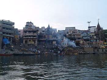
During festival seasons, over 70 million people bathe in the Ganges[14] to clean themselves from their past sins. Some materials like food, waste or leaves are left in the Ganges which are responsible for its pollution. Traditional beliefs hold that being cremated on its banks and to float down the Ganges will atone for the sins of those who die and carry them directly to salvation. In Varanasi alone, an estimated forty thousand bodies are cremated every year, many of those are only half-burnt.[7]
Dams and pumping stations
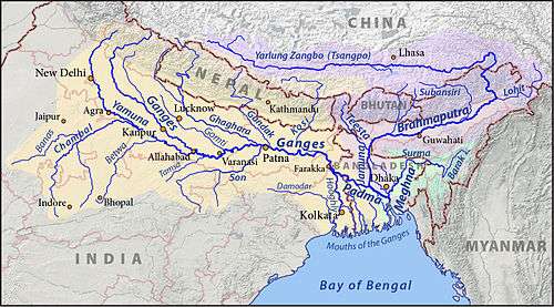
Built in 1854 during the British colonisation of India, the Haridwar dam has led to decay of the Ganges by greatly diminishing the flow of the river.[15] The Farakka Barrage was built originally to divert fresh water into the Hooghly River but has since caused an increase of salinity in the downstream of the Ganges, having a damaging effect on the ground water and soil along the river.[12] The barrage has caused major tension between Bangladesh and India. Bangladesh is actively considering to construct Ganges Barrage Project for mitigating the salinity problem.[16] The government of India has planned about 300 dams on the Ganges and its tributaries in the near future despite a government-commissioned green panel report that has recommended scrapping 34 of the dams citing environmental concerns.[17]
Three more barrages across the Ganges main river are existing at Bijnor, Narora and Kanpur.[18] The barrages at Bijnor and Narora divert all the water including baseflows during dry season to the canals for irrigating vast area up to Allahabad city. Most of the water available at the upstream of the Kanpur barrage is used during dry season for the cities drinking water needs.[19] Downstream of Kanpur barrage, adequate water is not available from the barrage to dilute the polluted water reaching the main river during the dry seasons of year.[20]
There are number of pumping stations located on the banks (right and left) of the Ganges downstream of Kanpur barrage serving the irrigation requirements of huge area.[21] These large pump houses are located at Rukunpur 26°10′21″N 80°38′57″E / 26.17250°N 80.64917°E, Kanjauli Kachhar 25°17′37″N 82°13′15″E / 25.29361°N 82.22083°E, Hakanipur Kalan 25°12′57″N 83°01′15″E / 25.21583°N 83.02083°E, Bhosawali 25°20′46″N 83°10′11″E / 25.34611°N 83.16972°E, Shekpur 25°32′13″N 83°11′57″E / 25.53694°N 83.19917°E, Chochakpur 25°28′55″N 83°25′11″E / 25.48194°N 83.41972°E, Lamui 25°23′20″N 83°32′11″E / 25.38889°N 83.53639°E, Chausa 25°31′11″N 83°54′04″E / 25.51972°N 83.90111°E, etc. (Refer to Google Earth maps) These lift irrigation schemes are pumping out most of the base flows available in the main river down stream of Kanpur city.
To make the Ganges live/flowing and dilute the polluted water inflows from habitations and industries, at least 5000 cusecs flow is required from Narora to Farakka as minimum environmental flow during the eight months dry season. This is possible by constructing storage reservoirs of capacity 100 Tmcft across the Ganges tributaries located up stream of Narora city and reserving the stored water only for minimum environmental flows. In addition, a series of cascading barrage cum bridges are to be constructed across the river from Kanpur to Allahabad to increase the surface area of impounded polluted water in the river so that it serves as vast natural oxidation ponds. The accumulated sediments/sludge would get washed away during the annual monsoon floods. Already, a number of barrages are planned between Farakka and Allahabad to make the 1620 km length of the river navigable from Haldia to Allahabad under National Waterway 1 project which can be extended up the Kanpur.[22]
Statistics
A 2006 measurement of pollution in the Ganges revealed that river water monitoring over the previous 12 years had demonstrated fecal coliform counts up to 100,000,000 MPN (most probable number) per 100 ml and biological oxygen demand levels averaging over 40 mg/l in the most polluted part of the river in Varanasi. The overall rate of water-borne/enteric disease incidence, including acute gastrointestinal disease, was estimated to be about 66%.[23]
A systematic classification done by Uttarakhand Environment Protection and Pollution Control Board’s (UEPPCB) on river waters into the categories A: safe for drinking, B: safe for bathing, C: safe for agriculture, and D: excessive pollution, put the Ganges in D. Coliform bacteria levels in the Ganges have also been tested to be at 5,500, a level too high to be safe for agricultural use let alone drinking and bathing.[24]
The leather industry in Kanpur which employs around 50,000 people in more than 400 tanneries uses chemicals such as toxic chromium compounds. Effectively, chromium levels have not decreased in the Ganges even after a common treatment plant was established in 1995. It now stands at more than 70 times the recommended maximum level.[25]
A study conducted by the National Cancer Registry Program (NCRP) under the Indian Council of Medical Research in 2012, suggested that "those living along its banks in Uttar Pradesh, Bihar and Bengal are more prone to cancer than anywhere else in the country".[26]
Effect
Marine life
The results of mercury analysis in various specimens collected along the basin indicated that some fish muscles tended to accumulate high levels of mercury. Of it, approximately 50–84% was organic mercury. A strong positive correlation between mercury levels in muscle with food habit and fish length was found.[27]
The Ganges River dolphin is one of few species of fresh water dolphins in the world. Listed as an endangered species, their population is believed to be less than 2000. Hydroelectric and irrigation dams along the Ganges that prevents the dolphins from travelling up and down river is the main reason for their reducing population.[28] The Ganges softshell turtle (Nilssonia gangetica) is found in the Ganges, Indus, and Mahanadi river systems of Pakistan, northern India, Bangladesh, and southern Nepal. This turtle inhabits deep rivers, streams, large canals, lakes and ponds, with a bed of mud or sand. According to the International Union for Conservation of Nature, freshwater turtle species are vulnerable. Due to their long lifespan and high trophic level in the aquatic food web, turtles are vulnerable to heavy metals pollution, a major kind of pollution in the Ganges.[29]
Wildlife
Some of the dams being constructed along the Ganges basin will submerge substantial areas of nearby forest. For example, the Kotli-Bhel dam at Devprayag will submerge 1200 hectares of forest, wiping out the river
Human beings
An analysis of the Ganges water in 2006 and 2007 showed significant associations between water-borne/enteric disease and the use of the river for bathing, laundry, washing, eating, cleaning utensils, and brushing teeth.[23] Water in the Ganges has been correlated to contracting dysentery, cholera, hepatitis,[13] as well as severe diarrhoea which continues to be one of the leading causes of death of children in India.[30]
During the summer and monsoon, hospital wards teem with children who need treatment for waterborne diseases - but according to S.C. Singh, a paediatrician at Varanasi Shiv Prasad Gupta Hospital, their parents rarely mention that they have been swimming in the river. They don't appear to have made the connection, he says.[31]
Cleanup efforts
Ganga Mahasabha
Ganga Mahasabha is an Indian organisation dedicated to the Ganges, founded by Madan Mohan Malviya in 1905. After a long struggle, British India agreed on 5 November 1914 that the uninterrupted flow of the Ganges is the rudimentary right of Hindu believers. The day is known as a 'Aviral Ganga Samjhauta Divas' (Uninterrupted Ganga flow agreement day) in the history of India and the agreement came into existence on 19 December 1916 which is known as Agreement of 1916. The sanctity of the agreement is not preserved by the state and central governments of India after independence though it is legally valid. More and more river water is diverted for irrigation use converting the river into a polluted sewer.
Ganges Action Plan
The Ganges Action Plan (GAP) was launched by Shri Rajiv Gandhi, then the Prime Minister of India, on June 1985 with covering 25 Class I towns (6 in Uttar Pradesh, 4 in Bihar and 15 in West Bengal)in India. Its main objective was to improve the water quality by the interception, diversion and treatment of domestic sewage and to prevent toxic and industrial chemical wastes from identified polluting units from entering the river. The other objectives of the GAP are as follows:
- Control of non-point pollution from agricultural run off, human defecation, cattle wallowing and the disposal of human remains in the river.
- Research and development to conserve the biotic diversity of the river to augment its productivity.
- Development of sewage treatment technology such as Up-flow Anaerobic Sludge Blanket (UASB) and sewage treatment through afforestation.
- Rehabilitation of soft-shelled turtles for pollution abatement.
- Resource recovery options such as methane production for energy generation and use of aquaculture for revenue generation.
- To act as trend setter for taking up similar action plans in other grossly polluted stretches in other rivers.
- The ultimate objective of the GAP is to have an approach of integrated river basin management considering the various dynamic interactions between abiotic and biotic eco-system.
Notwithstanding some delay in the completion of the first phase of the GAP it has generated considerable interest and set the scene for evolving a national approach towards replicating this program for the other polluted rivers of the country. The Government of India proposed to extend this model with suitable modifications to the national level through a National River Action Plan (NRAP). The NRAP mainly draws upon the lessons learnt and the experience gained from the GAP besides seeking the views of the State Governments and the other concerned Departments/Agencies. Under NRCP scheme the CPCB had conducted river basin studies and had identified 19 gross polluted stretches and 14 less polluted stretches along 19 rivers, which include 11 stretches situated along 7 rivers of M.P. It was much more effective as compared to the previous launched programs.
National River Ganga Basin Authority (NRGBA)
NRGBA was established by the Central Government of India, on 20 February 2009 under Section 3 of the Environment Protection Act, 1986. It declared the Ganges as the "National River" of India.[32] The chair includes the Prime Minister of India and chief ministers of states through which the Ganges flows.[33] In 2011, the World Bank "approved $1 billion in funding for the National Ganges River Basin Authority."[34]
Supreme Court of India
The Supreme Court of India has been working on the closure and relocation of many of the industrial plants like Tulsi along the Ganges. In 2010 the government declared the stretch of river between Gaumukh and Uttarkashi an Eco-sensitive zone.[24]
Namami Gange Programme
In the budget tabled in Parliament on 10 July 2014, the Union Finance Minister Arun Jaitley announced an integrated Ganged development project titled 'Namami Gange' (meaning 'Obeisance to the Ganges river') and allocated ₹2,037 crore for this purpose.[10]
As a part of the program, government of India ordered the shut down of 48 industrial units around the Ganges.[35]
The program has a budget outlay of Rs. 20,000 crore for the next five years. This is a significant four-fold increase over the expenditure in the past 30 years (Government of India incurred an overall expenditure of approximately Rs. 4000 crore on this task since 1985). The Centre will now take over 100% funding of various activities/ projects under this program. Taking a leaf from the unsatisfactory results of the earlier Ganges Action Plans, the Centre now plans to provide for operation and maintenance of the assets for a minimum 10-year period, and adopt a PPP/SPV approach for pollution hotspots.
In an attempt to bolster enforcement the Centre also plans to establish a four-battalion Ganga Eco-Task Force. The program emphasises on improved co-ordination mechanisms between various Ministries/Agencies of Central and State governments. Major infrastructure investments which fall under the original mandate of other ministries viz. Urban Development (UD), Drinking Water & Sanitation (DWS), Environment Forests & Climate Change (EF&CC) etc., will be undertaken in addition.
‘Namami Gange’ will focus on pollution abatement interventions namely Interception, diversion and treatment of waste water flowing through the open drains through bio-remediation / appropriate in-situ treatment / use of innovative technologies / sewage treatment plants (STPs) / effluent treatment plant (ETPs); rehabilitation and augmentation of existing STPs and immediate short term measures for arresting pollution at exit points on river front to prevent inflow of sewage etc.
Significantly the approach is underpinned by socio-economic benefits that the program is expected to deliver in terms of job creation, improved livelihoods and health benefits to the vast population that is dependent on the river. [36]
Ganga Manthan
Ganga Manthan was a national conference held to discuss issues and possible solutions for cleaning the river.[37][38]
The conference aimed to take feedback from stakeholders and prepare a road map for rejuvenating the Ganga. The event was organised by the National Mission for Clean Ganga (NMCG)on 7 July 2014 at Vigyan Bhawan in New Delhi.[39][40]
Nepal to release water during lean flow period
Nepal has constructed many barrages (excluding joint projects with India) or pump houses to divert the lean season river flows for irrigation purpose.[41] These water diversion projects are located near 28°25′29″N 81°22′49″E / 28.42472°N 81.38028°E, 28°02′24″N 81°57′12″E / 28.04000°N 81.95333°E, 27°52′51″N 82°30′13″E / 27.88083°N 82.50361°E, 27°40′00″N 83°06′49″E / 27.66667°N 83.11361°E, 27°42′17″N 84°25′57″E / 27.70472°N 84.43250°E, 27°08′11″N 85°29′01″E / 27.13639°N 85.48361°E, 26°53′09″N 86°08′13″E / 26.88583°N 86.13694°E, 26°50′13″N 87°09′01″E / 26.83694°N 87.15028°E, 26°41′05″N 87°52′43″E / 26.68472°N 87.87861°E, etc. India being lower riparian state has right to claim share out of the river water flows from Nepal similar to India entered into river water sharing agreement with Bangladesh recognising it as lower riparian state.[42] Till now there is no bilateral agreement between India and Nepal adhering to equitable sharing of river waters during the lean season. When Nepal releases water into India during the lean flow period, it would help in cleaning / diluting the polluted waters of downstream Ganga river up to Farakka barrage.
Water diversion from Manasarovar lake

For restoring the minimum environmental flows, it is difficult to identify nearly 100 Tmcft storage reservoirs in the hilly region of Ganga basin in India as the river is flowing through steep valleys. Already big storage reservoirs like Tehri and Ramganga are constructed at feasible locations. However the water of Manasarovar Lake located in China can be diverted to the upstream of Kanpur barrage (117 m msl) via Girijapur Barrage (129 m msl) located at 28°16′21″N 81°05′09″E / 28.27250°N 81.08583°E across the Ghaghara/Karnali river which is a tributary of Ganga river flowing from Tibet/China and Nepal.[43]
Manasarovar Lake's surface area is 320 square kilometres (120 sq mi) and its maximum depth is 90 m (300 ft). It holds more than 100 tmcft water in its top 13 meters depth. At present it is overflowing into nearby Lake Rakshastal which is a land locked salt water endorheic lake. The annual water inflows from the catchment area of Manasarovar lake located at 4,590 metres (15,060 ft) above msl, can be diverted by gravity to the Karnali River basin of China through a 15-kilometre long tunnel.[43]
The diverted water available continuously can be used in China for hydroelectric power generation where the head drop available is in excess of 800 meters over a 40 km long stretch. This would be a joint project of China, Nepal and India for controlling river water pollution and making the Ganga river live and flowing throughout the year. With the diversion of Manasarovar lake water to Ganga basin, Lake Rakshastal would turn into a Soda lake with further increase in water salinity which is useful in abstracting the water-soluble chemicals on commercial scale.[43]
The fresh water inflows into Manasarovar lake can be augmented further substantially by gravity diversion of the inflows available from the major catchment area of Rakshastal lake to Manasarovar lake by constructing an earth dam isolating northern tip of Rakshastal lake where it is fed by its substantial catchment area and also connected to the Manasarovar lake.[43]
Utilisation of Ganga and Bramhaputra flood waters to fight pollution in all rivers of India
Massive storage capacity fresh water coastal reservoir can be established on the shallow sea area adjoining West Bengal, Odisha and Bangladesh coast by constructing sea dikes / bunds/ causeway up to the depth of 15 meters.[44][45][46][47] Water can be pumped from this artificial fresh water lagoon throughout the year with abundant solar power resource of India to many river basins in India for meeting needs of agriculture, maintaining environmental flows, salt export requirements, etc. Nearly 150 billion cubic meters (bcm) storage capacity fresh water coastal reservoir/lagoon can be located on the sea area which stretches from Kutubdia island of Bangladesh (near 21°44′23″N 91°53′01″E / 21.73972°N 91.88361°E) to the mouth of Brahmani River (near 20°49′37″N 86°57′57″E / 20.82694°N 86.96583°E). The dike would be envisaged with gated barrages to pass to the sea the excess flood waters (total mean annual flow 1200 bcm) received from the Ganga, Brahmaputra rivers, etc. for limiting the full reservoir level (FRL) to 1.0 m above MSL.[48]
From this coastal reservoir, water is pumped up to the elevation of nearly 425 m MSL (near to 21°55′17″N 86°09′07″E / 21.92139°N 86.15194°E) in the Brahmani river basin for further transfer to most of the area of Damodar River basin, Subarnarekha River basin, Brahmani River basin, Mahanadi River basin in Jharkhand, Odisha, Chhattisgarh and West Bengal states. The Hasdeo Bango reservoir (near 22°36′47″N 82°37′27″E / 22.61306°N 82.62417°E) would receive the Ganga water and further pumped into the Narmada, Sone, Tapti, Yamuna, Sutlej, Luni, Chambal, Ghaggar, Ganga, etc. river basins for using in Maharashtra, Madhya Pradesh, Chhattisgarh, south Uttar Pradesh, south Bihar, Rajasthan, Gujarat, Haryana, Punjab and Delhi states. See Google earth maps for more geographical information. Further, water can be pumped into the Bagh reservoir and Upper Indravati reservoir located in Godavari River basin to transfer Ganga water into Godavari basin and further to south Indian river basins.
The minimum water flow from Bangladesh coast to the Bay of Bengal sea is 7,000 cumecs which is equal to 220 bcm annually. This water can also be put to use in addition to the impounded water by the coastal reservoir. The advantage of this scheme is that Ganga and Bramhaputra river waters can be stored on Bay of Bengal sea area and nearly 440 bcm water @ 14,000 cumecs transferred throughout the year to other river basins including Ganga basin at optimum pumping head.[49]
Nearly 1000 million tons (500 million cubic meters) of sediment annually from Ganga and Brahmaputra rivers is settling in the sea coast of Bangladesh and India and the sea area is shallow (up to 15 m depth) for at least 50 km wide. Bangladesh plagued with high population density, can reclaim nearly 6,000 km2 (4% of its total land) area of sea by excavating/dredging sediment from the fresh water lagoon bed without any effect on the water storage of the coastal reservoir.[50]
The presence of the protective sea dike makes sub sea soil dredging easier and economical through protection from rough sea waves. This reclaimed area from the sea can be utilised for locating a megacity to cater to the modern needs of Bangladesh. This coastal dike would protect the Bangladesh from the wave and tidal activity during the frequent cyclones preventing human and property losses drastically and also from sea level rise due to global warming. Thus Bangladesh would also benefit immensely with this coastal reservoir project.
The sea dike top level at 8 m above the mean sea level and 50 m wide at the top surface, would be nearly 520 km long connecting Indian mainland to South east of Bangladesh forming transnational high way and rail route from the Indian subcontinent to East Asia up to Singapore and China. Also this dike can be used as access way connecting deep sea ports located close to this dike. The proposed dike would be similar to the land reclamation of North Sea area called Delta Works in Netherlands. The experience of the Saemangeum Seawall already constructed in South Korea which is 33 km long and with 36 meters average depth, can be utilised for this project which is a lesser challenging project. Locks arrangement (similar to Panama canal) would be provided for the movement of ships from the open sea to harbours located in Bangladesh and India.
This man made lagoon area can also be used for shipping, ship breaking, ship building, etc. purposes.[51] The lagoon can also be broken into parts and interconnected by underwater tunnels/ ducts (nearly 500 meters long) in case existing ports and famous beach resorts must be protected. The cost of the total project including sea dikes, water pumping stations (60 GW), canal drop hydropower stations (15 GW), main canals, tunnels, aqueducts, barrages, distribution canals and the required solar power generation plants (200 GW) is estimated nearly ![]()
2010 Government clean-up campaign
In 2010, it was announced that "the Indian government has embarked on a $4 billion campaign to ensure that by 2020 no untreated municipal sewage or industrial runoff enters the 1,560-mile river."[55] A World Bank spokesman described the plan in 2011, saying
Earlier efforts to clean the Ganga concentrated on a few highly polluting towns and centres and addressed 'end-of-the-pipe' wastewater treatment there; Mission Clean Ganga builds on lessons from the past, and will look at the entire Gangetic basin while planning and prioritising investment instead of the earlier town-centric approach.[34]
Lobby group Sankat Mochan Foundation (SMF) "is working with GO2 Water Inc., a Berkeley, California, wastewater-technology company" to design a new Sewage treatment system for Varanasi.[55]
Protests for cleaning the Ganges
Nigamanand
In early 2011, a Hindu monk named Swami Nigamananda Saraswati fasted to death, protesting against pollutive river bed quarrying of the Ganges happening in the district of Haridwar, Uttarakhand.[56] Following his death in June 2011, his ashram leader Swami Shivananda fasted for 11 days starting on 25 November 2011, taking his movement forward. On 5 December 2011, the Government of Uttarakhand released an order to ban river bed mining in the Bhogpur and Bishanpur ghats.[57] According to administration officials, quarrying in the Ganga would now be studied by a special committee which would assess its environmental impacts on the river and its nearby areas.
Prof. G D Agrawal
Dr G. D. Agrawal is a notable environment activist and patron of Ganga Mahasabha (An organisation founded by Madan Mohan Malviya in 1905, demanding removal of dams on Ganga) who has been on a fast for 107 days protesting for a cleaner Ganga.[58] Because of support from other social activists like Anna Hazare, the then Prime Minister of India, Manmohan Singh agreed to Prof. Agrawal's demands. Accordingly, he called for a National River Ganga Basin Authority (NRGBA) meeting and urged the authorities to utilise the ₹26 billion (US$520M) sanctioned "for creating sewer networks, sewage treatment plants, sewage pumping stations, electric crematoria, community toilets and development of river fronts".[2] Agrawal died on 11 October 2018, after being on an indefinite fast since 22 June 2018, demanding the government act on its promises to clean and save river Ganga.[59]
See also
References
- ↑ Conaway, Cameron (23 September 2015). "The Ganges River is Dying Under the Weight of Modern India". Newsweek. Retrieved 11 April 2017.
- 1 2 3 "'Ganga receives 2,900 million ltrs [sic] of sewage daily'". www.hindustantimes.com. Archived from the original on 9 September 2015. Retrieved 14 May 2015.
- ↑ "The WaterHub". Retrieved 14 May 2015.
- ↑ Emily Wax (17 June 2007). "A Sacred River Endangered by Global Warming". Washington Post. Retrieved 25 June 2017.
- ↑ Robert Flynn. Holy Literary License: The Almighty Chooses Fallible Mortals to Write, Edit, and Translate GodStory. Wings Press. p. 96. Retrieved 13 July 2017.
- ↑ "Most Polluted Rivers in the World: These Are the Worst 11 - TakePart". TakePart. Archived from the original on 15 July 2017. Retrieved 15 July 2017.
- 1 2 3 Wohl, Ellen E. 2012. A world of rivers: environmental change on ten of the world's great rivers. Chicago: University of Chicago Press.
- ↑ Ganga, Yamuna banks cleaned 12 November 2013
- ↑ "Indian News - India Newspaper - India Latest News - News From India - India News Daily - Current India News". Retrieved 14 May 2015.
- 1 2 "Namami Ganga development Project gets 2037 crores". IANS. news.biharprabha.com. Retrieved 10 July 2014.
- ↑ Mohit Dubey (2 August 2016). "RTI revelation: Rs 2,958 crore spent on Ganga 'clean-up' without visible results". The Economic Times. Retrieved 25 June 2017.
- 1 2 "The Water Page - River Ganges". African water.org. 12 December 1996. Retrieved 9 July 2012.
- 1 2 "Sacred Ganges Carries Toxic Pollution". Retrieved 14 May 2015.
- ↑ "Hindus pilgrims bathe in Ganga - World news - South and Central Asia - NBC News". msnbc.com. Retrieved 14 May 2015.
- ↑ "Remove dams & encroachments to clean Ganga". Retrieved 14 May 2015.
- ↑ "Bangladesh seeks Indian cooperation to build $4 billion Ganges barrage". Retrieved 14 February 2016.
- ↑ "300 dams on the Ganga: A bane or a boon?". IBNLive. Retrieved 14 May 2015.
- ↑ "CPCB says there is need to regulate withdrawal of water from Ganga". Retrieved 24 December 2015.
- ↑ "Contaminated water a curse for people". The Times of India. 6 May 2013. Archived from the original on 21 July 2014.
- ↑ "Centre notifies minimum environmental flows for River Ganga". Retrieved 11 October 2018.
- ↑ "list of head works (Dams,_Barrages, Weirs, Anicuts, Lifts) on Ganga river". Retrieved 14 May 2015.
- ↑ "Ganga Waterways Project Raises Hopes and Fears". Retrieved 14 April 2016.
- 1 2 Hamner S, Tripathi A, Mishra RK, Bouskill N, Broadaway SC, Pyle BH, Ford TE. "The role of water use patterns and sewage pollution in incidence of water-borne/enteric diseases along the Ganga river in Varanasi, India.", International Journal of Environmental Health Research, Montana, USA, 2006 Apr 16.
- 1 2 Daftuar, Swati (25 July 2011). "Polluted flows the Ganga". The Hindu. Chennai, India.
- ↑ "Indians keep faith with Ganga despite pollution"
- ↑ Anirban Ghosh (17 October 2012). "Ganga is now a deadly source of cancer, study says". Times of India. Retrieved 25 June 2017.
- ↑ Moumita Pal, Santinath Ghosh, Madhumita Mukhopadhyay, Mahau Ghosh.Ganga and Yamuna. "Methyl mercury in fish—a case study on various samples collected from Ganga river at West Bengal.", Environmental Monitoring and Assessment, 8 June 2011.
- ↑ "Ganga River Dolphin". World Wildlife Fund. Retrieved 14 May 2015.
- ↑ Malik, R. N., Ghaffar, B., & Hashmi, M. Z. (2013). Trace metals in Ganges softshell turtle (aspideretes gangeticus) from two barrage: Baloki and rasul, pakistan. Environmental Science and Pollution Research International, 20(11), 8263-73. doi:https://dx.doi.org.proxy.hil.unb.ca/10.1007/s11356-013-1805-8
- ↑ "Problems and Solutions for the Ganga River". Retrieved 14 May 2015.
- ↑ Naskar, Sudhiti (1 July 2014). "The river where swimming lessons can be a health hazard". BBC News. Retrieved 4 July 2014.
- ↑ "National River Ganga Basin Authority"
- ↑ "Composition of NGRBA."
- 1 2 McDermott, Matt (1 June 2011). "World Bank Approves $1 Billion For Ganga River Cleanup". TreeHugger. Retrieved 4 July 2014.
- ↑ "48 industrial units polluting Ganga asked to close down". Patrika Group. 15 July 2014. Retrieved 15 July 2014.
- ↑ "Approval to Namami Gange - Integrated Ganga Conservation Mission / Programme under National Ganga River Basin Authority".
- ↑ Ganga Manthan
- ↑ "Ganga Manthan tomorrow: National meet to debate over river cleaning". The Indian Express. 6 July 2014. Retrieved 14 May 2015.
- ↑ "National meet on Ganga cleaning to be held tomorrow". dna. Retrieved 14 May 2015.
- ↑ "Pollution in holy river to be discussed in 'Ganga Manthan'". The Times of India. Retrieved 14 May 2015.
- ↑ "Existing and planned hydro dams in Nepal". Retrieved 14 March 2016.
- ↑ "River water sharing treaty between India and Bangladesh" (PDF). Retrieved 14 May 2015.
- 1 2 3 4 "Catchment area map of lakes Manasarovar and Rakshastal". International Centre for Integrated Mountain Development(ICIMOD). Retrieved 12 August 2015.
- ↑ "Efficacy of coastal reservoirs to address India's water shortage by impounding excess river flood waters near the coast (page 49)". Retrieved 9 July 2018.
- ↑ "International Association for Coastal Reservoir Research". Retrieved 9 July 2018.
- ↑ "Coastal reservoirs strategy for water resource development-a review of future trend". Retrieved 9 March 2018.
- ↑ "Reservoir in sea to end Bengaluru's drinking water problems?". Retrieved 9 March 2018.
- ↑ IWMI Research Report 83. "Spatial variation in water supply and demand across river basins of India" (PDF). Retrieved 23 June 2015.
- ↑ "Ganga & Bramhaputra river's water flow data, India". Retrieved 26 May 2015.
- ↑ "Bangladesh, a physically growing country". Retrieved 14 May 2015.
- ↑ "Feasibility of coastal reservoir to harness Godavari river surplus waters". Retrieved 21 September 2018.
- ↑ "India is not running out of water, water is running out of India". Retrieved 9 July 2018.
- ↑ "Harnessing gigantic hydro power potential of Indus, Jhelum and Chenab rivers in India". Retrieved 30 November 2017.
- ↑ "Water Quality Database of Indian rivers, MoEF". Retrieved 15 September 2016.
- 1 2 Pokharel, Krishna (13 February 2010). "India's Holy Ganges Gets a Cleanup: Government Embarks on $4 Billion Campaign to Treat Heavily Polluted Waters; Devout Hindus Revere River as 'Goddess'". Wall Street Journal. Retrieved 4 July 2014.
- ↑ Dube, Priyanka (14 June 2011). "Sadhu dies after a 73-day fast to save Ganga". ibnlive.in.com. CNN-IBN. Retrieved 14 June 2011.
Swami Nigamanand
- ↑ "Shivanand breaks fast after forcing curb on Ganga bed quarrying". The Pioneer. CMYK Printech. Archived from the original on 16 May 2012.
- ↑ "'The govt doesn't care for the issue Prof GD Agrawal is fasting for'". Tehelka.com. Retrieved 14 May 2015.
- ↑ "'Ganga Activist' GD Agrawal, On Fast From About 4 Months For Clean Ganga, Dies At 87 - HeadLines Today". headlinestoday.org. Headlines Today. 11 October 2018. Retrieved 11 October 2018.
External links
- Ganga gets dirtier by the day as the Government dithers -- Daily Pioneer
- National River Conservation Directorate
- Eco Friends Ganges conservation
- - Ganga Action Plan Phase I (June-1985 to 31 March 2000)
- - PLANNING COMMISSION REPORT ON UTILIZATION OF FUNDS AND ASSETS CREATED THROUGH GANGA ACTION PLAN IN STATES UNDER GAP