Tehri Dam
| Tehri Dam | |
|---|---|
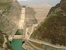 The dam in 2008; dam depth is 855 feet | |
 Location of Tehri Dam in Uttarakhand | |
| Country | India |
| Location | Uttarakhand |
| Coordinates | 30°22′40″N 78°28′50″E / 30.37778°N 78.48056°ECoordinates: 30°22′40″N 78°28′50″E / 30.37778°N 78.48056°E |
| Status | Operational |
| Construction began | 1978 |
| Opening date | 2006 |
| Construction cost | US $2.5 billion |
| Owner(s) | THDC INDIA LIMITED |
| Dam and spillways | |
| Type of dam | Embankment, earth and rock-fill |
| Impounds | Bhagirathi River |
| Height | 260.5 m (855 ft) |
| Length | 575 m (1,886 ft) |
| Width (crest) | 20 m (66 ft) |
| Width (base) | 1,128 m (3,701 ft) |
| Spillways | 2 |
| Spillway type | Gate controlled |
| Spillway capacity | 15,540 m3/s (549,000 cu ft/s) |
| Reservoir | |
| Total capacity | 4.0 km3 (3,200,000 acre⋅ft) |
| Surface area | 52 km2 (20 sq mi) |
| Power Station | |
| Commission date | 2006 |
| Type | Pumped-storage |
| Turbines | Francis pump turbines |
| Installed capacity |
1,000 MW (1,300,000 hp) Max. planned: 2,400 MW |
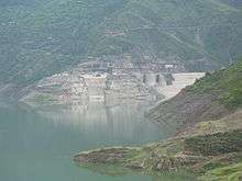
The Tehri Dam is the highest dam in India and one of the highest in the world. It is a multi-purpose rock and earth-fill embankment dam on the Bhagirathi River near Tehri in Uttarakhand, India. It is the primary dam of the THDC India Ltd. and the Tehri hydroelectric complex. Phase 1 was completed in 2006. The Tehri Dam withholds a reservoir for irrigation, municipal water supply and the generation of 1,000 megawatts (1,300,000 hp) of hydroelectricity. The dam's 1,000 MW variable-speed pumped-storage scheme is currently under construction with expected commissioning in May 2018.[1][2]
History
A preliminary investigation for the Tehri Dam Project was completed in 1961 and its design was completed in 1972 with a 600 MW capacity power plant based on the study. Construction began in 1978 after feasibility studies but was delayed due to financial, environmental and social impacts.
In 1986, technical and financial assistance was provided by the USSR, but this was interrupted years later with political instability. India was forced to take control of the project and at the first it was placed under the direction of the Irrigation Department of Uttar Pradesh. However, in 1988 the Tehri Hydro Development Corporation was formed to manage the dam and 75% of the funding would be provided by the federal government, 25% by the state. Uttar Pradesh would finance the entire irrigation portion of the project.
Technical description
Tehri Dam is a 260.5 m (855 ft) high rock and earth-fill embankment dam. Its length is 575 m (1,886 ft), crest width 20 m (66 ft), and base width 1,128 m (3,701 ft). The dam creates a reservoir of 4.0 cubic kilometres (3,200,000 acre⋅ft) with a surface area of 52 km2 (20 sq mi). The installed hydrocapacity is 1,000 MW along with an additional 1,000 MW of pumped storage hydroelectricity. The lower reservoir for the pumped-storage plant is created by the Koteshwar Dam downstream.
The Tehri Dam and the Tehri Pumped Storage Hydroelectric Power Plant are part of the Tehri Hydropower Complex which also includes the 400 MW Koteshwar Dam.[3] Power is distributed to Uttar Pradesh, Uttarakhand, Punjab, Delhi, Haryana, Jammu & Kashmir, Chandigarh, Rajasthan and Himachal Pradesh. The complex will afford irrigation to an area of 270,000 hectares (670,000 acres), irrigation stabilization to an area of 600,000 hectares (1,500,000 acres), and a supply of 270 million imperial gallons (1.2×10⁶ m3) of drinking water per day to the industrialized areas of Delhi, Uttar Pradesh and Uttarakhand.
The total expenditure for this project was USD 1 billion. The Indian National Trust for Art and Cultural Heritage (INTACH), a cost benefit analysis was commissioned and was concluded that the construction cost of the dam twice the projected benefits.[4]
Scheduling and generation dispatch
The scheduling and dispatch of the Tehri Hydro Power plant is done by Northern Regional Load Dispatch Center which is the apex body to ensure the integrated operation of the power system grid in the Northern region and comes under Power System Operation Corporation Limited (POSOCO). At present, THDC India Ltd. is generating around 3,000 GWh annually from this dam.
Environmental issues
The Tehri Dam has been the object of protests by environmental organizations and local people of the region. V.D. Saklani, lawyer and founder of the Anti-Tehri Dam Struggle Committee, was quick to point out the consequences associated to the large project.[5] Environmental activist Sunderlal Bahuguna led the Anti-Tehri Dam movement from 1980s till 2004.[6][7] The protest was against the displacement of town inhabitants and environmental consequence of the weak ecosystem.
In addition to the human rights concerns, the project has spurred concerns about the environmental consequences of locating such a large dam in the fragile ecosystem of the Himalayan foothills. There are further concerns regarding the dam's geological stability. The Tehri dam is in the Central Himalayan Seismic Gap, a major geologic fault zone. This region was the site of a 6.8 magnitude earthquake in October 1991, with an epicenter 53 km (33 mi) from the dam. Dam proponents claim that the complex is designed to withstand an earthquake of 8.4 magnitude, but some seismologists say that earthquakes with a magnitude of 8.5 or more could occur in this region. Were such a catastrophe to occur, the potentially resulting dam-break would submerge numerous towns downstream, whose populations total near half a million.
The relocation of more than 100,000 people from the area has led to protracted legal battles over resettlement rights and, ultimately, resulted in the project's delayed completion.[8]
Since 2005, filling of the reservoir has led to the reduced flow of Bhagirathi water from the normal 1,000 cu ft/s (28 m3/s) to a mere 200 cu ft/s (5.7 m3/s). This reduction has been central to local protest against the dam, since the Bhagirathi is considered part of the sacred Ganges whose waters are crucial to Hindu beliefs. At some points during the year, the tampering with Bhagirathi waters means this tributary stops flowing. This has created resentments among many Hindus, who claim that the sanctity of the Ganges has been compromised for the generation of electricity. The officials say that when the reservoir is filled to its maximum capacity the flow of the river will again become normal. In spite of concerns and protestation, operation of the Tehri Dam continues.
References
- ↑ "Variable Speed Pumped Hydroelectric Storage". Retrieved 5 October 2017.
- ↑ "Projects: Current Status". Tehri Hydro Development Corporation. Retrieved 5 October 2015.
- ↑ Tehri Dam: An Engineering Marvel, by Basistha Raj Adhikari
- ↑ "IRN FACT SHEET" (PDF). Tehri Dam: 3. October 2002.
- ↑ https://www.culturalsurvival.org/publications/cultural-survival-quarterly/tehri-dam-india-stumbling-toward-catastrophe
- ↑ "Protectors of Nature". The Hindu. 2016-06-23. ISSN 0971-751X. Retrieved 2016-07-03.
- ↑ Dutta, Ratnajyoti (2016-03-08). "Save earth for next generation: Chipko legend". BigWire. Retrieved 2016-07-03.
- ↑ Terminski, Bogumil (2013). "Development-Induced Displacement and Resettlement: Theoretical Frameworks and Current Challenges", Indiana University, available at http://dlc.dlib.indiana.edu/dlc/handle/10535/8833?show=full
- Official website of the Tehri Hydro Development Corporation Limited, the organization in charge of the dam's construction
- Tehri: The Sinking Town a traveller's account of Tehri dam.
- Tehri Lake: Memories from Old Tehri, A Backpacker at Tehri Lake
- Gaur, Vinod K. and Valdiya, K. S. (1993) Earthquake Hazard and Large Dams in the Himalaya, Indian National Trust for Art and Cultural Heritage, New Delhi, ISBN 81-900281-2-X
- Nawani, PC et al. (2006) "TEHRI DAM PROJECT – A Geotechnical Appraisal," Geological Survey of India Bulletin: Series B, No.62, ISSN 0445-622X
External links
| Wikimedia Commons has media related to Tehri Dam. |
- Tehri Hydro Power Complex on the Bhagirathi River in India Journal Power Technology and Engineering (formerly Hydrotechnical Construction), Springer, New York ISSN 1570-145X (Print) ISSN 1570-1468 (Online) Vol. 34, No. 8-9 / Aug, 2000 doi:10.1023/A:1004187208788, pp 479–484, 2 November 2004