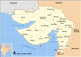
Kalpasar Project
The Kalpasar Project envisages building a 30 km dam across the Gulf of Khambat in India for establishing a huge fresh water coastal reservoir for irrigation, drinking and industrial purposes.[1][2] A 10 lane road link will also be set up over the dam, greatly reducing the distance between Saurashtra and South Gujarat.[3]
Etymology
‘Kalpasar’ means a lake that fulfills all the wishes. The word originating from Hindu mythological ‘Kalpa Vriksha’ (Devanagari: कल्पवृक्ष) – wishing tree.[4]
History
The Gulf of Khambhat was identified as a promising site for tidal power generation by UNDP Expert, Mr. Eric Wilson in the year 1975. Successive governments were then presented in details the possibility of a project, aptly named Kalpasar Project by its visionary Dr. Anil Kane, who conceptualised it in 80s as a feasible project. In 1988-89 a reconnaissance report was prepared for the dam across the Gulf of Khambhat. The report concluded that, assuming sound foundation conditions, the closure of the Gulf was technically feasible.[5] Studies are still going on and the length of the proposed dam is reduced and the tidal power component is dropped. The cost of project is estimated at ₹90,000 crore (as of 2017). It is reported that the project may take 20 years to complete if found feasible and approved.[6]
Objectives
Kalpasar aims at the creation of a fresh water coastal reservoir in the Gulf of Khambhat by the construction of a dam connecting the east and west bank of the Gulf. In the reservoir the runoff from Sabarmati, Mahi, Dhadar and Narmada will be stored, together with the waters from the Saurashtra rivers discharging into the Gulf of Khambhat. The stored waters are to be used for irrigation, domestic and industrial water requirements in the Saurashtra region.[7] Kalpasar is considered the evident solution for solving on the short as well as on the long term the threatening drinking and irrigation water problems in Saurashtra.
Once the Gulf is closed, water levels within the reservoir can be controlled while the tidal fluctuation outside the reservoir continues and, hence, can be harnessed for the generation of tidal energy.
In addition to fresh water storage and tidal power generation, Kalpasar also aims at land reclamation, transportation improvements and fisheries development. In accordance with this project, a mega fresh water reservoir will be constructed on the upstream side of the dam by impounding the surplus waters of numerous rivers.
This project, will resolve four vital problems of the State of Gujarat which are water, electrical power, road-rail transport and development of ports.[4]
Economics
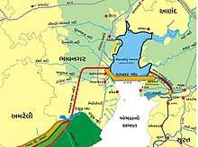
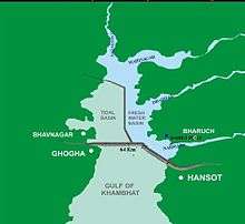
A state government release said the Rs 55,000 crore (US$11.7 billion) project, to be completed by 2020, will have a vast fresh water reservoir with gross storage of 16,791 million cubic metres of water, 64 km long dam across the Gulf of Khambhat connecting Ghogha in Bhavnagar with Hansot in Bharuch District, reducing the distance between the two by 225 km. It will have tidal power generation house with an installed capacity of 5,880 MW. Another estimate was given by the Government in October, 2010 which stated the proposed dam to be built just north of Bhavnagar in the west to Alandar in Dahej on the east.[8]
Current status
- Originally conceptualised & visualised by Dr. Anil Kane, on a call by the Government of Gujarat for water solution for Saurashtra region in 80s, the Kalpasar project of the Gujarat government, which envisages building of dam over the Gulf of Khambhat to establish huge reservoir, will commence in 2012, a year later than expected.[9]
- M S Patel, Secretary Kalpasar project, Government of Gujarat, said: “The project has been put on the fast track and will commence by 2012. It will take around seven years to complete it.”
- In 2008, B N Navalawala, advisor to Chief Minister Narendra Modi, had said the project would be launched by 2010-11. The new announcement was made while Patel was addressing a workshop on groundwater management in the coastal areas of Gujarat.
- The alignment of kalpsar has been changed towards north between Kala Talav, Bhavnagar to Aladar, Dahej near Bharuch. Idea of tidal power project is dropped. Only fresh water reservoir is proposed. Narmada river is excluded but its water will be diverted to kalpsar by constructing a check dam near Bhadbhut, Bharuch; with an about 30 km long, one lac cusecs canal off taking from it to kalpsar. Plan of fresh water distribution is changed and now focused to Saurashtra.[10]
- As per a report published on 20 December 2011, in the newspaper The Times Of India, the commencement has been further pushed to year 2013.[11]
- Now the entire Gulf of Khambhat area is undergoing Bathymatric and Land Survey for determining sea bed levels under the supervision of NIOT, Chennai.[12][13]
See also
References
- ↑ "Efficacy of coastal reservoirs to address India's water shortage by impounding excess river flood waters near the coast (page 49)". Retrieved 9 July 2018.
- ↑ "International Association for Coastal Reservoir Research". Retrieved 9 July 2018.
- ↑ "South Korea to Build Sea Wall in India". Retrieved 23 March 2016.
- 1 2 "Kalpsar Project : World's Largest Lake". Newser. 2016-11-18. Retrieved 2017-01-01.
- ↑ "Work on Gujarats Kalpasar project likely to commence by next year". Retrieved 29 May 2014.
- ↑ "Kalpasar to take at least 20 years, if found feasible - Times of India". The Times of India. Retrieved 2017-07-15.
- ↑ "India is not running out of water, water is running out of India". Retrieved 9 July 2018.
- ↑ "Gujarat plans first over the sea dam". Retrieved 29 May 2014.
- ↑ "Modi's hankering for illusory legacy of mega water project" (PDF). Retrieved 29 May 2014.
- ↑ "Kalpasar to take at least 20 years, if found feasible". Retrieved 29 June 2017.
- ↑ "Kalpasar to break ground in 2013". Retrieved 29 May 2014.
- ↑ "Kalpasar Project". Retrieved 29 May 2014.
- ↑ "Kalpasar Project (Yojana) : World's Largest Lake". Retrieved 29 June 2017.
External links
Coordinates: 21°27′21″N 72°24′57″E / 21.45583°N 72.41583°E