Meix-devant-Virton
| Meix-devant-Virton | |||
|---|---|---|---|
| Municipality | |||
 | |||
| |||
 Meix-devant-Virton Location in Belgium
Location of Meix-devant-Virton in Luxembourg province 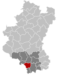 | |||
| Coordinates: 49°36.3′N 05°28.8′E / 49.6050°N 5.4800°ECoordinates: 49°36.3′N 05°28.8′E / 49.6050°N 5.4800°E | |||
| Country | Belgium | ||
| Community | French Community | ||
| Region | Wallonia | ||
| Province | Luxembourg | ||
| Arrondissement | Virton | ||
| Government | |||
| • Mayor | Pascal François | ||
| • Governing party/ies | Mayeur | ||
| Area | |||
| • Total | 54.20 km2 (20.93 sq mi) | ||
| Population (1 January 2017)[1] | |||
| • Total | 2,806 | ||
| • Density | 52/km2 (130/sq mi) | ||
| Postal codes | 6769 | ||
| Area codes | 063 | ||
| Website | (in French) www.meix-devant-virton.be | ||


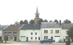
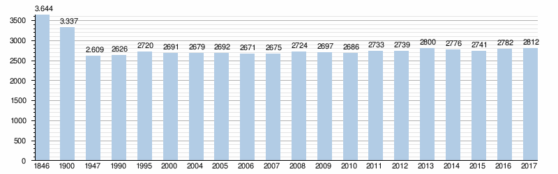
Meix-devant-Virton (in gaumais Minch-duvant-Vèrtan, in walloon Méch-divant-Vierton) is a municipality of Gaume located in the Belgian province of Luxembourg. On 1 January 2017 the municipality had 2,812 inhabitants. The total area is 54.2 km², giving a population density of 54 inhabitants per km².
The municipality consists of the following sub-municipalities: Meix-devant-Virton, Gérouville, Robelmont, Sommethonne, and Villers-la-Loue. Other population centers include: Belle Vue, Berchiwé, Houdrigny, La Soye and Limes.
Geography
It is located in the Lorraine Gaumaise, near Orval Abbey, Avioth and Virton.
railway line 165 Athus-Meuse and the Chevratte, an affluent of the Ton. The national road 88 is linking Florenville and Athus (Aubange) and coming from Dampicourt in the south, it heads west toward Gérouville and the French border.
Demography
Security and safety
The municipality is part of the Gaume Police Zone and the Luxembourg safety zone for firemen. The emergency number for those two services is 112.
See also
References
- ↑ Population per municipality as of 1 January 2017 (XLS; 397 KB)
External links

Places adjacent to Meix-devant-Virton | |
|---|---|
Municipalities of Luxembourg Province | ||
|---|---|---|
| Arlon |  | |
| Bastogne | ||
| Marche-en-Famenne | ||
| Neufchâteau | ||
| Virton | ||