Fauvillers
| Fauvillers | |
|---|---|
| Municipality | |
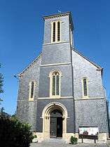 Fauvillers: church of the Sacred Heart (1877) | |
 Fauvillers Location in Belgium
Location of Fauvillers in Luxembourg province 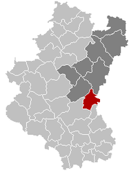 | |
| Coordinates: 49°51′N 05°40′E / 49.850°N 5.667°ECoordinates: 49°51′N 05°40′E / 49.850°N 5.667°E | |
| Country | Belgium |
| Community | French Community |
| Region | Wallonia |
| Province | Luxembourg |
| Arrondissement | Bastogne |
| Government | |
| • Mayor | Nicolas Stilmant |
| • Governing party/ies | CONTAC |
| Area | |
| • Total | 74.11 km2 (28.61 sq mi) |
| Population (1 January 2017)[1] | |
| • Total | 2,251 |
| • Density | 30/km2 (79/sq mi) |
| Postal codes | 6637 |
| Area codes | 063 |
| Website | www.fauvillers.be |
Fauvillers (German: Feitweiler, Luxembourgish: Fäteler, Walloon: Faiviè) is a Walloon municipality of Belgium located in the province of Luxembourg. On 1 January 2007 the municipality, which covers 74.11 km², had 2,071 inhabitants, giving a population density of 27.9 inhabitants per km².
The municipality consists of the following sub-municipalities: Fauvillers proper, Hollange, and Tintange. Other population centers include:
- Bodange
- Burnon
- Honville
- Hotte
- Malmaison
- Menufontaine
- Sainlez
- Strainchamps
- Warnach
- Wisembach
References
- ↑ Population per municipality as of 1 January 2017 (XLS; 397 KB)
External links

Places adjacent to Fauvillers | ||||||||||
|---|---|---|---|---|---|---|---|---|---|---|
| ||||||||||
Municipalities of Luxembourg Province | ||
|---|---|---|
| Arlon |  | |
| Bastogne | ||
| Marche-en-Famenne | ||
| Neufchâteau | ||
| Virton | ||
This article is issued from
Wikipedia.
The text is licensed under Creative Commons - Attribution - Sharealike.
Additional terms may apply for the media files.