Libin
| Libin | ||
|---|---|---|
| Municipality | ||
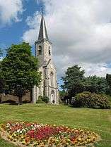 Libin: the church of Our Lady of Mount Carmel | ||
| ||
 Libin Location in Belgium
Location of Libin in Luxembourg province 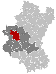 | ||
| Coordinates: 49°59′N 05°15′E / 49.983°N 5.250°ECoordinates: 49°59′N 05°15′E / 49.983°N 5.250°E | ||
| Country | Belgium | |
| Community | French Community | |
| Region | Wallonia | |
| Province | Luxembourg | |
| Arrondissement | Neufchâteau | |
| Government | ||
| • Mayor | Henri Guillaume (GDC) | |
| • Governing party/ies | GDC, AVEC | |
| Area | ||
| • Total | 139.72 km2 (53.95 sq mi) | |
| Population (1 January 2017)[1] | ||
| • Total | 5,083 | |
| • Density | 36/km2 (94/sq mi) | |
| Postal codes | 6890 | |
| Area codes | 061 | |
| Website | www.libin.be | |
.svg.png)
Libin is a Walloon municipality of Belgium located in the province of Luxembourg. On 1 January 2007 the municipality, which covers 139.72 km², had 4,655 inhabitants, giving a population density of 33.3 inhabitants per km².
The municipality consists of the following sub-municipalities: Libin proper, Anloy, Ochamps, Redu, Smuid, Transinne, and Villance. Other population centers include: Glaireuse, Hamaide, Lesse, Libin-Bas, Libin-Haut, and Sèchery.
Redu is famous for its bookshops, and for hosting a large European Space Agency ground station. Also in the municipality is the Euro Space Center tourist attraction, close to Transinne.
See also
References
- ↑ Population per municipality as of 1 January 2017 (XLS; 397 KB)
External links

Places adjacent to Libin | |
|---|---|
Municipalities of Luxembourg Province | ||
|---|---|---|
| Arlon |  | |
| Bastogne | ||
| Marche-en-Famenne | ||
| Neufchâteau | ||
| Virton | ||
This article is issued from
Wikipedia.
The text is licensed under Creative Commons - Attribution - Sharealike.
Additional terms may apply for the media files.