Libramont-Chevigny
| Libramont-Chevigny | |
|---|---|
| Municipality | |
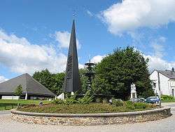 The new church in Libramont | |
 Libramont-Chevigny Location in Belgium
Location of Libramont-Chevigny in Luxembourg province 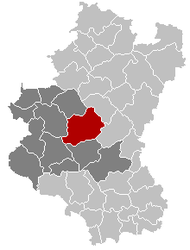 | |
| Coordinates: 49°55′N 05°23′E / 49.917°N 5.383°ECoordinates: 49°55′N 05°23′E / 49.917°N 5.383°E | |
| Country | Belgium |
| Community | French Community |
| Region | Wallonia |
| Province | Luxembourg |
| Arrondissement | Neufchâteau |
| Government | |
| • Mayor | Pierre Arnould |
| • Governing party/ies | Mouvement Réformateur (MR) |
| Area | |
| • Total | 177.86 km2 (68.67 sq mi) |
| Population (1 January 2017)[1] | |
| • Total | 11,154 |
| • Density | 63/km2 (160/sq mi) |
| Postal codes | 6800 |
| Area codes | 061 |
| Website | libramont-chevigny.be |
Libramont-Chevigny is a Walloon municipality of Belgium located in the province of Luxembourg. On February 1, 2015 the municipality, which covers 177.86 km², had 10,955 inhabitants, giving a population density of 61,59 inhabitants per km².
The municipality consists of the following sub-municipalities: Bras, Freux, Libramont, Moircy, Recogne, Remagne, Sainte-Marie-Chevigny, and Saint-Pierre. Other population centers include:
- Bernimont
- Bonnerue
- Bougnimont
- Chenet
- Flohimont
- Jenneville
- Lamouline
- Laneuville
- Neuvillers
- Nimbermont
- Ourt
- Presseux
- Renaumont
- Rondu
- Sberchamps
- Séviscourt
- Wideumont
The Ourthe Occidentale river originates in the municipality of Libramont-Chevigny, near the hamlet of Ourt.
Notable inhabitants
See also
References
- ↑ Population per municipality as of 1 January 2017 (XLS; 397 KB)
External links

- Official website

Places adjacent to Libramont-Chevigny | ||||||||||
|---|---|---|---|---|---|---|---|---|---|---|
| ||||||||||
Municipalities of Luxembourg Province | ||
|---|---|---|
| Arlon |  | |
| Bastogne | ||
| Marche-en-Famenne | ||
| Neufchâteau | ||
| Virton | ||
This article is issued from
Wikipedia.
The text is licensed under Creative Commons - Attribution - Sharealike.
Additional terms may apply for the media files.