Paliseul
| Paliseul | |||
|---|---|---|---|
| Municipality | |||
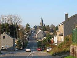 Bouillon Street | |||
| |||
 Paliseul Location in Belgium
Location of Paliseul in Luxembourg province 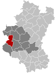 | |||
| Coordinates: 49°54′N 05°08′E / 49.900°N 5.133°ECoordinates: 49°54′N 05°08′E / 49.900°N 5.133°E | |||
| Country | Belgium | ||
| Community | French Community | ||
| Region | Wallonia | ||
| Province | Luxembourg | ||
| Arrondissement | Neufchâteau | ||
| Government | |||
| • Mayor | Jean Pol Hannard (Plus) | ||
| • Governing party/ies | Plus, Ensemble | ||
| Area | |||
| • Total | 112.96 km2 (43.61 sq mi) | ||
| Population (1 January 2017)[1] | |||
| • Total | 5,336 | ||
| • Density | 47/km2 (120/sq mi) | ||
| Postal codes | 6850-6853, 6856 | ||
| Area codes | 061 | ||
| Website | (in French) paliseul.be | ||
.svg.png)
Paliseul is a Walloon municipality of Belgium located in the province of Luxembourg. On 1 January 2007 the municipality, which covers 112.96 km², had 5,055 inhabitants, giving a population density of 44.8 inhabitants per km².
The municipality consists of the following sub-municipalities: Paliseul proper, Carlsbourg, Fays-les-Veneurs, Framont, Maissin, Nollevaux, Offagne, and Opont. Other population centers include: Beth, Bour, Merny, Our, and Plainevaux.
See also
References
- ↑ Population per municipality as of 1 January 2017 (XLS; 397 KB)
External links

Municipalities of Luxembourg Province | ||
|---|---|---|
| Arlon |  | |
| Bastogne | ||
| Marche-en-Famenne | ||
| Neufchâteau | ||
| Virton | ||
This article is issued from
Wikipedia.
The text is licensed under Creative Commons - Attribution - Sharealike.
Additional terms may apply for the media files.