Furg Citadel
 Forg Castle (Mirza Rafi Khan Castle) | |
 Shown within Iran | |
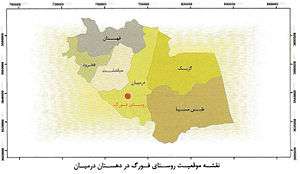
| Location | Darmian, Iran |
|---|---|
| Region | South Khorasan Province |
| Coordinates | 32°50′41″N 59°56′55″E / 32.8448°N 59.9485°ECoordinates: 32°50′41″N 59°56′55″E / 32.8448°N 59.9485°E |
| Type | Settlement |
| History | |
| Periods | Afsharian |
| Site notes | |
| Ownership | Mixed public and private |
| Public access | Partial |
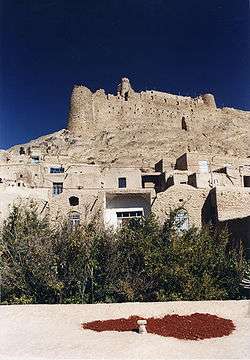
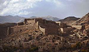
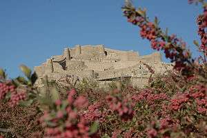
The Citadel of Furg, or Arg e Furg, is a citadel from the 12th century, located in Furg Village in Darmian County, South Khorasan, Iran. The citadel was founded by Meerza Muhammad Rafiee Darmiany I (Lama).[1]
Fork Castle or Mirza Rafi Khan Castle is located in South Khorasan Province, Iran. It has to a great extent survived deliberate and natural destructive events, and sustained itself despite passage of time. The castle is located in Forg Village.[2] five kilometers from the city of "Darmaian",[3] South Khorasan Province.
Situation and structure
Fork Castle is located on the north side Fork Village at an altitude of 1840 meters on the edge of the heights of Darmian Valley leading to Asadiyeh plain. It has a good strategic situation, because it has a commanding view of the entire village, farms and roads around its eastern region. The area of the Castle is about 9200 square meters which extends from east to west. The main entrance of the castle is located within the eastern walls, which is also the lowest point of the castle. In general, in the architecture of the castle from the east to the west, three major parts are recognizable. The first part on the east includes a barn, living place of crew, place of keeping cattle and dock warehouse. The second part of the castle, which is in the center of the castle, is located on a higher altitude than the first part and has been constructed at a distance of 50 meters from the place of food and military supplies and place of residing soldiers, and the third part which has the centrality state of the castle has been built in the highest part of the castle on two floors overlooking the entire village and the roads the area. In the eastern part of the castle including entrance, guard towers, water storage and other spaces, it is impossible to discern the purpose of their construction, owing to high rate of their destruction. Due to existence of the remnants of tower and rampart in the middle of the section with the first part, it is likely that this part was the second defensive phase of the castle, so that the defensive layers of the main part of the castle, i.e. Kohandej, is more completed. There is a brick tower with cruciform or lozenge design decorations in the northeast corner of this part which is known as penthouse tower among the people of the village. The third part of the castle located in the utmost west and the highest part of the castle is separated from the second part by two towers and fortified and long walls. The existence of these towers and ramparts shows the great importance of this part. This part is considered as the alcove of castle has more untouched spaces than the previous two parts. The existence of spaces like the vestibule, connecting corridors, stables, food storage, watchtowers and spaces with other applications are the most important specifications of this part; Alcove or citadel consists of two floors of which the upper floor, except the limited area, have been destroyed. The other architectural element is a burrow that has an exit door, and which has been designed for water supply during castle siege or for emergency and clandestine exit.
This underground tunnel has many stairs, of which some one hundred are still usable. These were used during the battle between Mirza Rafi Khan with Mir Alam Khan and his son Amir Asadollah Khan. This battle is referred to in Einolvaghaye[4]"… Esmaeil Khan, Atakhan, and their families obeyed and followed; and Afghans with Mirza Rafi Khan, Haji Fathkhan Afghan and Behboud son of Nazarkhan Ghalehgahi erected a burrow on one side of the Castle and escaped at night". In this part the author may have made a mistake. They most likely used the same burrow that had previously been made. Otherwise; digging a burrow in a limited period of time during the war to escape was not possible. One of the key features of the castle is its physical and spatial structure, which follows the topography of its location, and the situation of which distinguishes it from other castles, particularly, mountain fortresses. In spite of the fact that the towers and the ramparts of the castle have provided the required strength to it, its location is not without defect in such manner that the mountains of the west castle are adjacent thereof. Using this weak point by the attackers has also been pointed out in Einolvaghaye. Of course, in respect of the problem mentioned above, it ought to be noted that the location of the castle should be studied within its own time. Perhaps in the era of Naseri (Naser al-Din Shah) in which cannons were vastly used in local wars in the region, this vulnerability of the castle has been revealed, while; in the early periods that these weapons were not common, perhaps it provided the best location. There is not yet an exact and documented comment on the early history of the castle construction. Based on the existing documents and the Book of Divan-e-Lame [5] and local comments, the construction of the building was started on the early 1160AH, during the reign of Nader Shah Afshar, by Mirza Bagha Khan, son of the First Mirza Rafi Khan, and then completed by his son, the Second Mirza Rafi Khan. Being unknown the right time of the construction of the castle has also been mentioned in Divan-e-Lame and said: "But, was it really started the building of the castle by Mirza Bagha Khan and completed by his son, Mirza Rafi Khan (Lame's grandson) or is it one of the old buildings and these two persons and the former ones, everyone has had a hand in it and made effort to repair and complete it, is something that has not been achieved yet; not based on the written documents and not through oral promise of the elders. Likely, Lame and his father had possessed the castle and it was their lace of residence and administration center and shelter at the time of their affliction and difficulty against attack of the then enemies and princes [6]
History
In the Book of Haghayeghol Akhbr Naseri,[7] on the events of the lunar year of 1268, it is said about Mirza Rafi Khan as follows: "In the same year, Mirza Rafi Khan, who was staying in Ghaenat places, started to oppose, General Pashakhan with two legions from city of Semnan and et al and a collective of cavalry and forty cannons were assigned to punish him. Mirza Rafi Khan went to Harat. Zahiroddoleh interceded for him, his crime was pardoned." In Qajar era, a hard conflict occurred between the chief town of Ghaenat and the chief town of "Forg" and "Darmian" which finally resulted in killing Mirza Rafi Khan and occupying the castle. Among the influential lieutenant governors within this time period, we can point out to Mirza Mohammad Baghakhan, son of the first Mirza Rafi Khan, the second Mirza Rafi Khan, the third Mirza Rafi Khan, Mohammad Ebrahim Khan, Abdolali Khan and Aligholi Khan. After the third Mirza Rafikhan having been killed, those of the same dynasty took the responsibility of lieutenant governor in Darmian and Forg. Among the considerable points about Darmian's lieutenant governors, is the struggles occurred between this lieutenant governor with Khozeimeh family who were ruling Birjand. These conflicts have also been mentioned in Divan-e-Lame, including partiality of Lame's family from Nader Shah and Khozeimeh from Safavids which caused dispute, conflict and competition. These competitions sometimes associated with marriage between the family of Rafiei and Khozeimeh, in this way not only it was trying to make inconspicuous the local conflicts and differences, but also to strengthen relationship and unity between them with other lieutenant governors and elders of the area. In the same way, six daughters of the second Mriza Rafi Khan married with the great persons and lieutenant governors of Birjand, Nehbandan, Fanoud and Noghab. The non-written documents and instruments in respect of the events related to the date of construction or historical and natural disasters that have taken place in this complex are limited and it needs more digging and studies. The only inscription carved on the mortar surface of the water storage of the castle indicates the lunar date of 1217 and suggests that the building was repaired by an artisan named "Abosaeid Jaiki" in the early Qajar era. The studies made on the local history of the region is also greatly in consistency with the dates and the sovereignty of Mirza Bakhakhan and after him, his children and his offspring especially the second Mirza Rafi Khan and the third Mirza Rafi Khan certifies the foregoing matters. However, there is little documented information on the matter that whether the castle had been existed before sovereignty of Rafiei family as the local governors or not. Description of this castle and its situation have been recorded in come historic books and itineraries, for example, Riazi Heravi writes in Einolvaghayeh Book as follows: "Forg Castle is 12 miles away from Birjand and locates around plain and entrance of "Darmian" valley and has a lot of gardens and trees and enjoys a good climate, the castle is on the top of a mountain of which walls and towers have been firmly constructed by mud bricks and its foundation was made by Ajin stone and has two Haji Shir around itself and two embankments each of which diameter is five cubits. The European tourists such as "Doctor Forbes" [8] in 1814 AD, "Colonel Mac GERGER" [9] in 1875, and "Khanykf" and "Blue" have visited the castle and have stated descriptions in their itineraries. Colonel Mac GARGAR also brought about the words of Doctor Forbes in his itinerary titled "A Journey to the Province of Khorasan" as follows: "The castle has been built on the top of a hill at an altitude of 2000 to 2500 feet which could be threatened by the fire load from the highlands of the north and west. A mountain is located in the south and on the other two sides which is away 1200 yards from the peak to the walls of the castle. An interesting point that Mac GERGER said as quoted by Doctor Forbes is: "Three water storages were provided inside the castle which is said that the storage of their water will supply the utility of a great garrison for the period of one year and six months.[10]
Archaeological excavations
The Forg Castle has been excavated two times so far. The first time was performed during the restoration operation of the castle in the year of 2001 in order to clarify the situation of plan and map of Kohandej. During the excavation, the spaces such as stable, food storage, underground burrow and corridors connecting different parts of the Kohandej were detected.[11] This monument has been registered in the List of National Works under No. 3450 on March 18, 2001. As stated above, based on the evidences and chronicles, the foundation of the building goes back to Afsharieh era. The attribution of Forg Castle (Mirza Rafi Khan Castle) to Ismailia [12] should be taken with caution because the Ismailia castles [13] have special characteristics, for example, most of them have been constructed in out of the way and mountainous areas in order to be hidden and camouflaged. In the castles Ismailia was putting their followers under military and sectarian trainings and sending them to different regions for assassination of the authorities opposing to their thoughts. The names of those people were in encrypted form, which were sometimes changed too. Acting stealthily, fighting against central government and their local puppet rulers and propagating ideological thought relating to Ismailia sect were the most important tasks fulfilled in the Ismailia castles. The central governments were trying to destroy the fortresses. The architecture and construction of these structures which were being founded with speed and limited resources have been entirely varied from the official governmental castles. As the peak time of the Ismailia sect's activities coincided with the Abbasid and Seljuk Caliphs and as this sect was removed due to the brutal attack of the Mongol on Iran, it is far-fetched that the overall present structure of Forg Castle would remain safe and applicable from that time through Afsharieh era. Consequently, the greatness and external specifications of Forg Castle differ from Ismailia castles and this castle has not been hidden and has been considered as an official and a visible governmental castle for protection and establishment of security of the region. The Iranian official castles consisted of three Kohandej (place of living the ruler), Sharestan (Place of living of the people of village) and Rabath (farms and gardens) sections since a long time ago. The three parts were connected together in such manner that this specification is observed in Forg Castle. Forg village surrounded the Forg Castle and attached to it since a long time ago, while Ismailia castles were away from the residential and inhabited regions and were lacking those features. Normally, castles were built to resist insurgency and rebellion, were mostly constructed on the top of mountains and in impassable passes, were often without a specified geometrical design or previous plan, and were irregularly built. But the official and governmental castles were being constructed with previous plan and by choosing the right strategic position overlooking the surrounding areas in plains or beside passages and caravan roads and/or on the borders in order to protect, to guard and to provide security to the desired regions. Therefore; the Forg Castle or Mirza Rafi Khan Castle is an official building; and its administrative and governmental nature is clear. It seems that the castle had governmental and official application for protecting surrounding areas and frontier control throughout the history.
See also
References
- ↑ Divan, Lama (1365 (persian)). Divan Lama. Sanobar. Check date values in:
|date=(help) - ↑ There are different opinions about appellation of Forg. One of them which is more common is the belief that Forg was commonly pronounced Fork among people. In Dehkhoda Dictionary as quoted from Encyclopedia, it has been explicitly mentioned that Fork is the name of the ancestor of a family in Iran, and is an Iranian name. The other version is that Fork was the name of the daughter of "Ryan Konouj", who was an Indian kings. Fork was the wife of Bahram Gour (as stated in Borhan) and/or perhaps it has been taken from Persian "Pour" meaning "son". Some others attribute Fork to the founder of this village, i.e. Mozafar Keyghobad, and based on an inscription on which the year of 307 is written, they infer that as the founder of this village was initially "Pour Keyghobad", it was firstly called "Pourg", and then was changed to Fork and then to Forg by lapse of time.
- ↑ City of "Darmian" has been located inside the mountains known as "Momenabad" in the east region of Iran which has been considered as a part of "Ghohestan" or "Kouhestan" vast territory in the past historical division. Momenabad district has very likely taken its name from Momenabad Mountain. Momenabad Mountain locating in South Khorasan with the altitude of 9100 feet is the highest mountain. In the Book of the Region History which is a compilation of Shah Abbas Safavid era, the political divisions of Ghohestan have been mentioned as follows: Ghohestan is a province with enough people in which there are many ranked and intellectual persons who was born there.
- ↑ Einolvaghaye is a book categorized as the general historiography including incidents of the history of Afghanistan from the year of 1207 through 1324 AH, authored by Mohammad Yousef Riazi Heravi. This book was written by Mohammad Yousef Riazi Heravi in City of Mashhadolrezaye Razavi in 1324 AH, 1906 A.D., in the period of immigration and being away from homeland. The edition of this book was terminated on February 19, 1990 in city of Mashhadolreza by Mohammad Asef Fekrat, and for the first time was published with circulation of two thousand copies in 1990. The "publisher" of this book is Dr. Mahmoud Afshar Yazdi Endowment Foundation and the book has been printed at the printing house of the University of Tehran. This book is a collection of historical instruments and documents of Naseri and Mozafari Eras.
- ↑ Divane Lame, Mohammad Rafi Ebne Abolkarim Darmiani, edited by Dr. Mahmoud Rafi and Dr. Mazaher Mosafa , published by Dr. Mahmoud Rafi , Tehran.
- ↑ The same as mentioned in Page No. 89
- ↑ Haghayegholakhbare Naseri is a chronicle book in Persian language in Qajar Era authored by Mohammad Jafar Ebne Mohammadali Khormoji edited by Hossein Khadiv Jam, an author of Mohammad Jafar Khormoji, a historian of Nasereddin Shah Qajar's royal, known as Haghayeghnegar (Fact Journalist). He commenced writing of this book at the request of Nasereddin Shah in 1276AH and as he, himself, says in its introduction, he was requested not to say a thing in his history other than the truth and fair one and not to consider traitor as servant and escaper as attacker. Khormoji completed writing of the first volume in Jamadiol Avval (the fifth month of the Arabic lunar year) 1279AH, and then started writing the second volume. The book has been written in two volumes. The first volume includes a preface written by the editor, Mr. Hossein Khadiv Jam; a note about the author written by Iraj Afshar; the subject-matter of the book and description of events until 1279AH. The second volume consists of the author's introduction and mentioning the events of the years of 1278 and 1279AH.
- ↑ Forbes, Frederick, Rawlinson W. Route from Turbat Haidari, in Khorasan, to the River Harir Rud, on the Borders of Sistan. Journal of the Royal Geographical Society of London, Vol. 14. (1844)
- ↑ Mac. Gerger, Colonel C. M., Description of a journey to the Province of Khorasan, translated by Majid Mehdizadeh, Mashhad, Deputy Office for Cultural Affairs, Astan Ghods Razavi, 1987.
- ↑ Mofid Shateri, Mehdi Rafiei, Behnaz Nejati, Darmian Nameh with Pointing out to Forg, Birjand, Chahar Derakht, 2015, Page, 175
- ↑ Nasrabadi, Alireza, Forg Castle Registration Report, Archive of the Deputy Office for Deputy Office for Cultural Heritage, Handicrafts and Tourism of South Khorasan, 2001.
- ↑ Ismailian State was a government founded in the City of Qazvin by conquering Alamout Castle in the year of 483 AH, and their commanding period continued until 654AH. The commanding center of Ismailian was Alamout Castle, and their main activity was fighting against the Abbasides Caliphs and Mongol tribes. Hassan Sabbah, as the most prominent commander of Ismailian, was able to expand his scope of power to the present Syria by extensive advertising amongst farmers and the poor. Finally, the Islamilian Government, after having ruled over Qazvin for the period of 200 years, was destroyed as a result of the Mongol Holakokhan’s assail.
- ↑ Ismailian Castles in Alborz Mountain Chain, written by Manouchehr Sotoudeh, Tehran, Tahori Publication, 1983
| Capital |  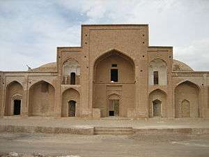  | ||||||||||||||||||||||
|---|---|---|---|---|---|---|---|---|---|---|---|---|---|---|---|---|---|---|---|---|---|---|---|
| Counties and cities |
| ||||||||||||||||||||||
| Sights |
| ||||||||||||||||||||||
| populated places | |||||||||||||||||||||||
| Styles |
|  | ||||||
|---|---|---|---|---|---|---|---|---|
| Types | ||||||||
| Elements | ||||||||
| Traditional cities | ||||||||
| Theory and analysis | ||||||||
| Lists |
| |||||||