Franklin, Quebec
| Franklin | |
|---|---|
| Municipality | |
 | |
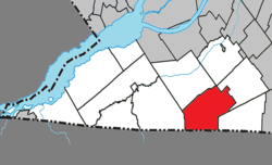 Location within Le Haut-Saint-Laurent RCM. | |
 Franklin Location in southern Quebec. | |
| Coordinates: 45°02′N 73°55′W / 45.033°N 73.917°WCoordinates: 45°02′N 73°55′W / 45.033°N 73.917°W[1] | |
| Country |
|
| Province |
|
| Region | Montérégie |
| RCM | Le Haut-Saint-Laurent |
| Constituted | March 31, 1973 |
| Government[2][3] | |
| • Mayor | Doug Brooks |
| • Federal riding | Beauharnois—Salaberry |
| • Prov. riding | Huntingdon |
| Area[2][4] | |
| • Total | 113.20 km2 (43.71 sq mi) |
| • Land | 113.14 km2 (43.68 sq mi) |
| Population (2011)[4] | |
| • Total | 1,688 |
| • Density | 14.9/km2 (39/sq mi) |
| • Pop 2006-2011 |
|
| • Dwellings | 767 |
| Time zone | UTC−5 (EST) |
| • Summer (DST) | UTC−4 (EDT) |
| Postal code(s) | J0S 1E0 |
| Area code(s) | 450 and 579 |
| Highways |
|
Franklin is a Canadian municipality located in the Montérégie region of Quebec along the Canada–US border. The population as of the Canada 2011 Census was 1,688.
Geography
The municipality is situated along the border with the United States.
Geological features include an east-west forested ridge Covey Hill, a foothill to the northern Adirondack Mountains of New York State, from which the skyscrapers of Montreal are visible to the northeast. Streams run from its northern flank to the Chateauguay Valley where tributaries feed the Chateauguay River that drains into the St. Lawrence River.
Communities
The following locations reside within the municipality's boundaries:[1]
- Dorea (45°00′21″N 73°55′43″W / 45.00583°N 73.92861°W) – a hamlet situated in the southern portion.
- Franklin Centre (45°01′42″N 73°55′29″W / 45.02833°N 73.92472°W) – a hamlet located at the junction of Route 202 and Route 209.
- Saint-Antoine-Abbé (45°03′03″N 73°53′21″W / 45.05083°N 73.88917°W) – a village located along Quebec Route 209.
Demographics
Population
| Canada census – Franklin, Quebec community profile | |||
|---|---|---|---|
| 2011 | 2006 | ||
| Population: | 1,688 (+2.2% from 2006) | 1,651 (+3.0% from 2001) | |
| Land area: | 113.14 km2 (43.68 sq mi) | 113.07 km2 (43.66 sq mi) | |
| Population density: | 14.9/km2 (39/sq mi) | 14.6/km2 (38/sq mi) | |
| Median age: | 45.0 (M: 44.8, F: 45.3) | 42.6 (M: 42.8, F: 42.1) | |
| Total private dwellings: | 767 | 726 | |
| Median household income: | $45,351 | $41,059 | |
| References: 2011[4] 2006[5] earlier[6] | |||
| Historical Census Data - Franklin, Quebec[7] | ||||||||||||||||||||||||||
|---|---|---|---|---|---|---|---|---|---|---|---|---|---|---|---|---|---|---|---|---|---|---|---|---|---|---|
|
|
| ||||||||||||||||||||||||
Language
| Canada Census Mother Tongue - Franklin, Quebec[7] | ||||||||||||||||||
|---|---|---|---|---|---|---|---|---|---|---|---|---|---|---|---|---|---|---|
| Census | Total | French |
English |
French & English |
Other | |||||||||||||
| Year | Responses | Count | Trend | Pop % | Count | Trend | Pop % | Count | Trend | Pop % | Count | Trend | Pop % | |||||
2011 |
1,685 |
1,210 | 71.81% | 390 | 23.14% | 35 | 2.08% | 50 | 2.97% | |||||||||
2006 |
1,650 |
1,220 | 73.94% | 345 | 20.91% | 10 | 0.61% | 75 | 4.54% | |||||||||
2001 |
1,565 |
1,160 | 74.12% | 355 | 22.68% | 25 | 1.60% | 25 | 1.60% | |||||||||
1996 |
1,630 |
1,180 | n/a | 72.39% | 390 | n/a | 23.93% | 20 | n/a | 1.23% | 40 | n/a | 2.45% | |||||
Economy
Apple orchards and maple sugar groves are the principal agriculture near the village of Franklin Centre, Quebec and on the hill while around the village of St. Antoine Abbe in the flat valley there are fertile croplands and dairy farms.
Leahy Orchards is a major employer and exporter of applesauce and Applesnax label products.
Attractions
"Chemin de Covey Hill" (Covey Hill road) is considered to be one of the premier cycling roads in southern Quebec. This is due to the impressive climb between Havelock and Franklin Centre, the breath-taking views of the St. Lawrence and Richelieu river valleys, as well as a surprisingly good quality road surface. This is the first road north of the US-Canada border.
See also
References
- 1 2 Reference number 23777 of the Commission de toponymie du Québec (in French)
- 1 2 Ministère des Affaires municipales, des Régions et de l'Occupation du territoire: Franklin
- ↑ Riding history for Beauharnois—Salaberry, Quebec from the Library of Parliament
- 1 2 3 "2011 Community Profiles". Canada 2011 Census. Statistics Canada. July 5, 2013. Retrieved 2014-02-13.
- ↑ "2006 Community Profiles". Canada 2006 Census. Statistics Canada. March 30, 2011. Retrieved 2014-02-13.
- ↑ "2001 Community Profiles". Canada 2001 Census. Statistics Canada. February 17, 2012.
- 1 2 Statistics Canada: 1996, 2001, 2006, 2011 census
External links
Adjacent Municipal Subdivisions | |
|---|---|
| Cities | |
|---|---|
| Municipalities | |
| Parishes | |
| Townships | |
| |