Forehoe and Henstead Rural District
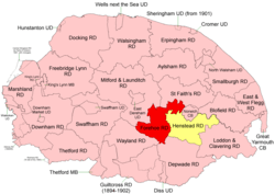 Boundaries in 1894. Forehoe RD in red, Henstead RD yellow. |
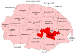 Boundaries in 1935 |
Forehoe and Henstead Rural Districts were adjacent rural districts in Norfolk, England from 1894 to 1935.[1][2]
They were formed under the Local Government Act 1894 based on rural sanitary districts of the same names, and lay generally south of Norwich.
In 1935 the Wymondham parish of Forehoe RD was created a new Wymondham Urban District. The remainder, together with the whole of Henstead RD apart from an island in the River Yare, were merged to form Forehoe and Henstead Rural District.[3] Subsequently, changes to the border with Norwich County Borough were made in 1968.
In 1974, the merged district was abolished under the Local Government Act 1972, and became part of the South Norfolk district.
Statistics
| Year | Forehoe RD | Henstead RD | ||||
|---|---|---|---|---|---|---|
| Area (ha) [4] |
Population [5] |
Density (pop/ha) |
Area (ha) [6] |
Population [7] |
Density (pop/ha) | |
| 1911 | 15,592 | 11,383 | 0.73 | 17,151 | 10,285 | 0.60 |
| 1921 | 11,305 | 0.73 | 9,901 | 0.58 | ||
| 1931 | 12,910 | 0.83 | 10,779 | 0.63 | ||
| Forehoe and Henstead RD[8][9] | ||||||
| 1951 | 28,304 | 23,376 | 0.83 | |||
| 1961 | 25,860 | 0.91 | ||||
Parishes
These parishes operated within Forehoe and Henstead RD unless otherwise indicated.
| Parish | From | To | Notes |
|---|---|---|---|
| Arminghall | 1935 | Henstead RD. Added to Bixley | |
| Barford | Forehoe RD | ||
| Barnham Broom | Forehoe RD | ||
| Bawburgh | Forehoe RD | ||
| Bixley | Henstead RD | ||
| Bowthorpe | 1935 | Forehoe RD. Added to Runhall | |
| Bracon Ash | Henstead RD | ||
| Bramerton | Henstead RD | ||
| Brandon Parva | 1935 | Forehoe RD. Added to Runhall | |
| Caistor St Edmund | Henstead RD | ||
| Carleton Forehoe | 1935 | Forehoe RD. Added to Kimberley | |
| Colney | Henstead RD | ||
| Colton | 1935 | Forehoe RD. Added to Marlingford | |
| Costessey | Forehoe RD | ||
| Coston | 1935 | Forehoe RD. Added to Runhall | |
| Cringleford | Henstead RD | ||
| Crownthorpe | 1935 | Forehoe RD. Added to Wicklewood | |
| Deopham | Forehoe RD | ||
| Dunston | 1935 | Henstead RD. Added to Stoke Holy Cross | |
| East Carleton | Henstead RD | ||
| Easton | Forehoe RD | ||
| Flordon | Henstead RD | ||
| Framingham Earl | Henstead RD | ||
| Framingham Pigot | Henstead RD | ||
| Great Melton | Henstead RD | ||
| Hackford | 1935 | Forehoe RD. Added to Deopham | |
| Hethersett | Henstead RD | ||
| Hingham | Forehoe RD | ||
| Holverston | Henstead RD | ||
| Intwood | 1935 | Henstead RD. Added to Keswick | |
| Keswick | Henstead RD | ||
| Ketteringham | Henstead RD | ||
| Kimberley | Forehoe RD | ||
| Kirby Bedon | Henstead RD | ||
| Little Melton | Henstead RD | ||
| Markshall | 1935 | Henstead RD. Added to Caistor St Edmund | |
| Marlingford | Forehoe RD | ||
| Morley | Merger of 2 Morley parishes | ||
| Morley St Botolph | 1935 | Forehoe RD. Component of Morley | |
| Morley St Peter | 1935 | Forehoe RD. Component of Morley | |
| Mulbarton | Henstead RD | ||
| Newton Flotman | Henstead RD | ||
| Poringland | Henstead RD | ||
| Rockland St Mary | Henstead RD | ||
| Runhall | Forehoe RD | ||
| Saxlingham Nethergate | Henstead RD | ||
| Saxlingham Thorpe | 1925 | Henstead RD. Added to Saxlingham Nethergate | |
| Shotesham | 1935 | Merger of 2 Shotesham parishes | |
| Shotesham All Saints | 1935 | Henstead RD | |
| Shotesham St Mary | 1935 | Henstead RD | |
| Stoke Holy Cross | Henstead RD | ||
| Surlingham | Henstead RD | ||
| Swainsthorpe | Henstead RD | ||
| Swardeston | Henstead RD | ||
| Trowse with Newton | Henstead RD | ||
| Welborne | 1935 | Forehoe RD. Added to Runhall | |
| Whitlingham | 1935 | Henstead RD. Aded to Kirby Bedon | |
| Wicklewood | Forehoe RD | ||
| Wramplingham | Forehoe RD | ||
| Wreningham | Henstead RD | ||
| Wymondham | 1935 | Forehoe RD. Became Wymondham UD |
References
- ↑ "Forehoe RD through time: Census tables with data for the Local Government District". A Vision of Britain through Time. GB Historical GIS / University of Portsmouth. Retrieved 1 July 2017.
- ↑ "Henstead RD through time: Census tables with data for the Local Government District". A Vision of Britain through Time. GB Historical GIS / University of Portsmouth. Retrieved 1 July 2017.
- ↑ "Forehoe and Henstead RD through time: Census tables with data for the Local Government District". A Vision of Britain through Time. GB Historical GIS / University of Portsmouth. Retrieved 1 July 2017.
- ↑ "Forehoe RD through time: Population Statistics: Area (acres)". A Vision of Britain through Time. GB Historical GIS / University of Portsmouth. Retrieved 1 Jul 2017.
- ↑ "Forehoe RD through time: Population Statistics: Total Population". A Vision of Britain through Time. GB Historical GIS / University of Portsmouth. Retrieved 1 Jul 2017.
- ↑ "Henstead RD through time: Population Statistics: Area (acres)". A Vision of Britain through Time. GB Historical GIS / University of Portsmouth. Retrieved 1 Jul 2017.
- ↑ "Henstead RD through time: Population Statistics: Total Population". A Vision of Britain through Time. GB Historical GIS / University of Portsmouth. Retrieved 1 Jul 2017.
- ↑ "Forehoe and Henstead RD through time: Population Statistics: Area (acres)". A Vision of Britain through Time. GB Historical GIS / University of Portsmouth. Retrieved 1 Jul 2017.
- ↑ "Forehoe and Henstead RD through time: Population Statistics: Total Population". A Vision of Britain through Time. GB Historical GIS / University of Portsmouth. Retrieved 1 Jul 2017.