Gold Line (Sacramento RT)
| Gold Line | |
|---|---|
 | |
| Overview | |
| Type | Light rail |
| System | Sacramento RT Light Rail |
| Status | Operational |
| Locale | Sacramento, California |
| Termini |
Downtown (west) Folsom (east) |
| Stations | 27 |
| Services | Route 507 |
| Operation | |
| Opened | March 12, 1987 (as Watt/I-80-Downtown-Butterfield) |
| Operator(s) | Sacramento Regional Transit District |
| Technical | |
| Track gauge | 1,435 mm (4 ft 8 1⁄2 in) standard gauge |
The Gold Line is a light rail transit line in the Sacramento Regional Transit District (RT) light rail system. Operating between Sacramento Valley and Historic Folsom stations, the lines runs primarily east-west in Sacramento (including downtown, Midtown, East Sacramento), portions of unincorporated Sacramento County, Rancho Cordova, Gold River and Folsom. Portions of the Gold Line run along the original initial alignment between 16th Street and Butterfield stations.
History
The first light rail line of the RT, which opened in 1987, was an 18.3-mile (29.5 km) route between Watt/I-80 station in North Sacramento, through downtown, and continuing east on Folsom Boulevard to Butterfield Way station. It was built at a cost of $176 million USD ($379 million adjusted for inflation), which included the cost of vehicles and maintenance and storage facilities. Much of the line, when it was first built, was single-tracked, though improvements over the 1990s allowed much of the original system to be double-tracked. The line was built mainly using the Sacramento Valley Railroad right-of-way, coupled with use of structures of an abandoned freeway project. A limited portion of the route runs on streets, mainly in downtown Sacramento.
The line became more popular than anyone anticipated, necessitating further expansions and improvements. Two new stations at 39th and 48th streets opened in 1995, and a 2.3-mile (3.7 km) extension to the Mather Field/Mills station was completed the same year. In June 2004, a further extension from Mather Field/Mills to Sunrise was opened.
On September 26, 2003, the South Line (now part of the Blue Line) opened for 6.3 miles (10.1 km) between the 16th Street station on the Watt/I-80-Downtown-Mather Field/Mills line and a station at Meadowview Road in the south end, which is the first phase of a planned longer 11.2-mile (18.0 km) line to Elk Grove. Much of the extension follows a railroad right-of-way. When it opened, 7 new stops were added to the system.
In June 2005, following a reconfiguration of the light rail system, the Sunrise-Downtown Line was created (it formerly continued beyond the downtown St. Rose of Lima Park station to Watt/I-80); it runs from St. Rose/K-Street to Sunrise with an extension to the Folsom area that opened on October 15, 2005. It has since been redesignated in color as the Gold Line. On December 8, 2006 it was extended even further to the downtown Amtrak depot (a.k.a. the Sacramento Valley Station), connecting the light rail system to the national rail system for the first time.
Line description
The Gold Line begins at its western terminus in downtown at the Sacramento Valley station where it connects with Amtrak. From there it travels on H Street in a single-track, then diverges into one-way tracks for 7th and 8th Streets where it joins the Blue and Green Lines. It then turns westward on O Street, southward on 12th, then eastward in an alley paralleling Q and R Streets. After passing the 16th Street station, the Gold Line splits from the Blue Line (the Green Line terminates at 13th Street station), crossing over the Bee Bridge before continuing on R Street in Midtown. It continues in its own right-of-way in East Sacramento next to Highway 50, then crosses under Highway 50 and parallels Folsom Boulevard for most of its length. The Gold Line then reaches its eastern terminus at Historic Folsom station in Folsom, although some trains terminate at Sunrise station.
Listing of stations on the Gold Line
Note: former stations are highlighted in gray. The 7th & K platform of the St. Rose of Lima Park station closed permanently as of September 30, 2016.
| Station | Opened | Bike lockers | Transfers |
|---|---|---|---|
| Sacramento Valley Station | 2006 | No | Amtrak RT buses 30,31 |
| 7th & I/County Center (outbound only) | 2007 | No | Green Line Many RT buses |
| 8th & H/County Center (inbound only) | 2012 | No | Green Line Many RT buses |
| 8th & K (inbound only) | 2006 | No | Green Line Many RT buses |
| St. Rose of Lima Park (southbound: 7th & K) | 1987 | No | Blue and Green Lines Many RT buses Closed September 30, 2016 |
| 7th & Capitol (outbound); 8th & Capitol (inbound) | 1987 | No | Blue and Green Lines Many RT buses |
| 8th & O | 1987 | No | Blue and Green Lines Many RT buses |
| Archives Plaza | 1987 | No | Blue and Green Lines |
| 13th Street | 1987 | No | Blue and Green Lines |
| 16th Street | 1987 | Yes | Blue Line RT bus 6 |
| 23rd Street | 1987 | Yes | No transfers on site |
| 29th Street | 1987 | No | RT buses 38, 67, 68, e-tran, El Dorado Transit, Mercy Hospital Shuttle, Sutter Hospital Shuttle |
| 39th Street | 1995 | Yes | RT bus 213, 214, UCDMC Shuttle |
| 48th Street | 1995 | Yes | No transfers on site |
| 59th Street | 1987 | Yes | No transfers on site |
| University/65th Street | 1987 | Yes | RT buses 26, 34, 36, 38, 81, 82, 87, Amador County Transit |
| Power Inn | 1987 | Yes | RT bus 61 |
| College Greens | 1987 | Yes | RT bus 61 |
| Watt/Manlove | 1987 | Yes | RT buses 72, 80, 84, 255 |
| Starfire | 1987 | Yes | RT buses 80, 84 |
| Tiber | 1987 | Yes | No bus transfers on site |
| Butterfield | 1987 | Yes | e-tran 70 and Roseville Transit 51 |
| Mather Field/Mills | 1998 | Yes | RT buses 21, 72, 74, 75, VA Hospital Shuttle |
| Zinfandel | 2004 | No | No transfers on Site |
| Cordova Town Center | 2004 | No | RT bus 28 |
| Sunrise | 2004 | Yes | RT bus 74 |
| Hazel | 2005 | No | No transfers on site |
| Iron Point | 2005 | No | Folsom Stage Lines |
| Glenn | 2005 | No | Folsom Stage Lines |
| Historic Folsom | 2005 | No | Folsom Stage Lines |
Fleet images
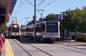 A CAF trainset Train at Mather Field/Mills station
 A CAF LRV at Archives Plaza Station
External links
| Wikimedia Commons has media related to Gold Line (Sacramento RT). |
Route map:
| Management | |||
|---|---|---|---|
| Bus System | |||
| RT Light Rail |
| ||
| Other | |||