Floyd, New York
| Floyd, New York | |
|---|---|
| Town | |
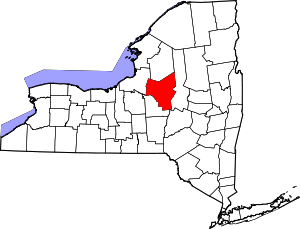
 Location in Oneida County and the state of New York. | |
| Coordinates: 43°13′31″N 75°19′54″W / 43.22528°N 75.33167°W | |
| Country | United States |
| State | New York |
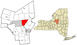
| County | Oneida |
| Government | |
| • Type | Town Council |
| • Town Supervisor | John F. Buczek (R) |
| • Town Council |
Members' List
|
| Area[1] | |
| • Total | 34.79 sq mi (90.11 km2) |
| • Land | 34.62 sq mi (89.66 km2) |
| • Water | 0.17 sq mi (0.45 km2) |
| Elevation | 889 ft (271 m) |
| Population (2010) | |
| • Total | 3,819 |
| • Estimate (2016)[2] | 3,776 |
| • Density | 109.08/sq mi (42.12/km2) |
| Time zone | UTC-5 (Eastern (EST)) |
| • Summer (DST) | UTC-4 (EDT) |
| ZIP code | 13440 |
| Area code(s) | 315 |
| FIPS code | 36-26385 |
| GNIS feature ID | 0978962 |
Floyd is a town in Oneida County, New York, United States. The population was 3,819 at the 2010 census. The town is named after William Floyd, a signer of the Declaration of Independence.[3]
The Town of Floyd is located east of the City of Rome and the former Griffiss Air Force Base.
The Erie Canal passes along the south part of the town.
History
The area was first settled around 1790. The Town of Floyd was founded in 1796 from the Town of Steuben. William Floyd, for whom the town is named, became a resident of Oneida County in 1794.
The population of Floyd was 1,227 in 1865,[4] but only 663 in 1920.
In the 19th century, Floyd was known for "Masonic, scholarly, political and anti-slavery activities."[5]
The Camroden Presbyterian Church was listed on the National Register of Historic Places in 2007.[6]
The town was briefly mentioned in the 1996 film "City Hall," where the two main characters were stuck in Floyd while waiting for snow to clear off the train tracks.
Geography
According to the United States Census Bureau, the town has a total area of 34.8 square miles (90 km2), of which, 34.6 square miles (90 km2) of it is land and 0.2 square miles (0.52 km2) of it (0.46%) is water.
The Mohawk River defines the south town line. The town has rolling hills, ascending to the north, which reach an elevation is about 200–300 feet above the river. Nine Mile Creek, which flows through the southeast part of the town, was originally known as Te-ya-nun-sak, or Teyanunsoke, "a beech tree standing."[4][5]
Demographics
| Historical population | |||
|---|---|---|---|
| Census | Pop. | %± | |
| 1800 | 767 | — | |
| 1810 | 970 | 26.5% | |
| 1820 | 1,488 | 53.4% | |
| 1830 | 1,699 | 14.2% | |
| 1840 | 1,742 | 2.5% | |
| 1850 | 1,419 | −18.5% | |
| 1860 | 1,440 | 1.5% | |
| 1870 | 1,209 | −16.0% | |
| 1880 | 1,115 | −7.8% | |
| 1890 | 920 | −17.5% | |
| 1900 | 785 | −14.7% | |
| 1910 | 697 | −11.2% | |
| 1920 | 663 | −4.9% | |
| 1930 | 752 | 13.4% | |
| 1940 | 828 | 10.1% | |
| 1950 | 1,014 | 22.5% | |
| 1960 | 2,234 | 120.3% | |
| 1970 | 3,620 | 62.0% | |
| 1980 | 3,863 | 6.7% | |
| 1990 | 3,856 | −0.2% | |
| 2000 | 3,869 | 0.3% | |
| 2010 | 3,819 | −1.3% | |
| Est. 2016 | 3,776 | [2] | −1.1% |
| U.S. Decennial Census[7] | |||
As of the census[8] of 2000, there were 3,869 people, 1,394 households, and 1,091 families residing in the town. The population density was 111.8 people per square mile (43.2/km²). There were 1,483 housing units at an average density of 42.9 per square mile (16.5/km²). The racial makeup of the town was 97.49% White, 0.36% African American, 0.18% Native American, 0.41% Asian, 0.08% Pacific Islander, 0.18% from other races, and 1.29% from two or more races. Hispanic or Latino of any race were 1.03% of the population.
There were 1,394 households out of which 38.8% had children under the age of 18 living with them, 63.0% were married couples living together, 10.4% had a female householder with no male present, and 21.7% were non-families. 17.3% of all households were made up of individuals and 7.4% had someone living alone who was 65 years of age or older. The average household size was 2.78 and the average family size was 3.11.
In the town, the population was spread out with 28.0% under the age of 18, 6.7% from 18 to 24, 29.7% from 25 to 44, 24.8% from 45 to 64, and 10.6% who were 65 years of age or older. The median age was 36 years. For every 100 females, there were 97.6 males. For every 100 females age 18 and over, there were 93.3 males.
The median income for a household in the town was $40,192, and the median income for a family was $44,583. Males had a median income of $33,151 versus $22,718 for females. The per capita income for the town was $17,405. About 2.8% of families and 4.2% of the population were below the poverty line, including 5.1% of those under age 18 and 5.6% of those age 65 or over.
Communities and locations in Floyd, NY
- Camroden – A hamlet in the northwest part of the town named by Welsh immigrants. Welsh was the predominant language here from 1825 until the late 1880's.[5]
- East Floyd – A hamlet in the northeast part of the town.
- Floyd – The hamlet of Floyd on NY 365.
- Pen Bonc Hill – An elevation in the northeast corner of the town.
- The Punch Bowl – The site of the first settlement, and of the first mill in the town.[4]
- South Hill – A small mountain range in the northeast corner of the town. Partially in the Town of Western.
- Steuben Valley – A hamlet at the northeast corner of the town.
- Stittville – A hamlet at the east town line.
Notable people
- Matthew Ewing, inventor and co-founder of Vacuum Oil Company
- Onias C. Skinner, Illinois jurist and legislator
References
- ↑ "2016 U.S. Gazetteer Files". United States Census Bureau. Retrieved Jul 5, 2017.
- 1 2 "Population and Housing Unit Estimates". Retrieved June 9, 2017.
- ↑ Gannett, Henry (1905). The Origin of Certain Place Names in the United States. Govt. Print. Off. p. 127.
- 1 2 3 Child, Hamilton (1869). Gazetteer and business directory of Oneida County. Syracuse, NY: Printed at the Journal office. pp. 90–91.
- 1 2 3 "Town Of Floyd: History: History [Digital Towpath]". town.floyd.ny.us. 2017. Retrieved 2017-09-30.
- ↑ National Park Service (2009-03-13). "National Register Information System". National Register of Historic Places. National Park Service.
- ↑ "Census of Population and Housing". Census.gov. Archived from the original on May 12, 2015. Retrieved June 4, 2015.
- ↑ "American FactFinder". United States Census Bureau. Archived from the original on 2013-09-11. Retrieved 2008-01-31.
External links
Coordinates: 43°13′11″N 75°20′04″W / 43.21972°N 75.33444°W