Flannan Isles
| Gaelic name | Na h-Eileanan Flannach |
|---|---|
| Pronunciation |
[nə ˈhelanən ˈfl̪ˠan̪ˠəx] ( |
| Meaning of name | Flannan Isles |
| Location | |
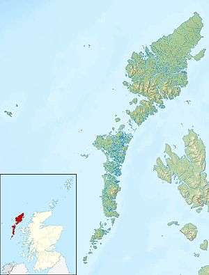 Flannan Isles Flannan Isles shown within the Outer Hebrides | |
| OS grid reference | NA720460 |
| Coordinates | 58°18′N 7°36′W / 58.3°N 7.6°W |
| Physical geography | |
| Island group | Lewis and Harris |
| Area | 58.87 hectares (145.5 acres) over more than seven islands.[1] |
| Area rank | Eilean Mòr is 325th [2] |
| Highest elevation | 88 m on Eilean Mòr |
| Administration | |
| Sovereign state | United Kingdom |
| Country | Scotland |
| Council area | Na h-Eileanan Siar |
| Demographics | |
| Population | 0 |
| Largest settlement | Flannan Isles Lighthouse is the only habitable structure |
| References | [3][4] |
The Flannan Isles (Scottish Gaelic: Na h-Eileanan Flannach)[5] or alternatively, the Seven Hunters are a small island group in the Outer Hebrides of Scotland, approximately 32 kilometres (20 mi) west of the Isle of Lewis. They may take their name from Saint Flannan, the seventh-century Irish preacher and abbot.[4]
The islands have been devoid of permanent residents since the automation of Flannan Isles Lighthouse in 1971.[6] They are the location of an enduring mystery that occurred in December 1900, when all three lighthouse keepers vanished without trace.
Geography
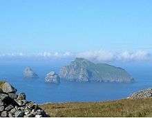
The islands are split into three groups: the main cluster of rocks that lie to the northeast include the two principal islands of Eilean Mòr (Big Isle), which is approximately 17.5 hectares (43 acres) in extent,[4] and Eilean Taighe (House Isle); to the south lie Soray (Eastward Isle) and Sgeir Tomain; while the main western outcrops are Eilean a' Gobha (Isle of the Blacksmith), Roaireim (which has a natural rock arch), and Bròna Cleit (Sad Sunk Rock). The total land area amounts to approximately 50 hectares (120 acres) and the highest point is 88 metres (289 ft) above sea level on Eilean Mòr.[4]

The geology consists of a dark breccia of gabbros and dolerites intruding Archaean gneiss.[4] In prehistoric times, the area was covered by ice sheets that spread from Scotland out into the Atlantic Ocean. After the last retreat of the ice circa 20,000 years BP, sea levels were as much as 122 metres (400 ft) lower than at present and it is likely that the existing islands were part of a much larger land mass, although still separated from the Outer Hebrides by many miles of open water. Steadily rising sea levels thereafter would have reduced the land remaining above sea level to its present extent.[8]
There are two possible landing places for yachts visiting Eilean Mòr to the east and west, although this may be hazardous given the regular heavy swells.[4]
History
As the name implies, Eilean Taighe hosts a ruined stone shelter. Eilean Mòr is home to the lighthouse and a ruined chapel dedicated to Saint Flannán, which the lighthouse keepers referred to as the "dog kennel" because of its small size. These ruined bothies were described collectively by the Ancient Monuments Commission as The Bothies of the Clan McPhail,[9] or Bothain Chlann ‘ic Phaill.[10]
It is not entirely clear to which St Flannan the chapel pays honours. It is likely that the honoree was either the 7th-century Abbot of Killaloe, County Clare, Ireland or alternatively, the half brother of the eighth century St Ronan who gave his name to the nearby island of North Rona. There was also a certain Flann, son of an Abbot of Iona, called Maol-duine, who died in 890 and may also have lent his name to these isolated isles.[4]
The archipelago is also known as The Seven Hunters. During the Middle Ages they also may have been called the Seven Haley (Holy) Isles.[11] Martin Martin (1703) lists a number of unusual customs associated with regular pilgrimages to Eilean Mòr, such as removing one's hat and making a sunwise turn when reaching the plateau.[12]
It is possible that the saint or his acolytes lived on Eilean Mòr and perhaps, on Eilean Taighe as well. It is unlikely, however, that there were permanent residents on the islands once the Celtic Church fell into decline in the Hebrides (as a result of ninth century Viking invasions), until the construction of the lighthouse and its occupation very shortly before the dawn of the twentieth century.
Flannan Isles Lighthouse was built near the highest point on Eilean Mòr for the Northern Lighthouse Board between 1895 and 1899. In 1900, its three keepers disappeared without trace, causing much public attention and speculation. The lighthouse is no longer occupied after it was automated in 1971. The isolated Isles are occasionally visited by amateur radio operators for DXpeditions.
Wildlife
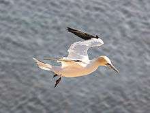
The isles provide nesting for a population of seabirds, including Atlantic puffins, northern fulmars, European storm-petrels, Leach's petrels, common shag, and black-legged kittiwakes. There is a gannetry on Roaireim.[10] From the late Middle Ages on, Lewismen regularly raided these nests for eggs, birds, and feathers. There is a population of rabbits, brought to the islands by the lighthouse keepers,[13] and crofters from Bernera graze sheep on the most fertile islands.[4] Minke and pilot whales, as well as Risso's and other species of dolphin are commonly observed in the vicinity.[10]
The islands became a Site of Special Scientific Interest in December 1983.[14]
In fiction
The Flannan Isles are the main setting in Robert W. Sneddons's short story On the Isle of Blue Men which was first published in Ghost Stories magazine in April 1927. The Scottish-American author's "atmospheric, Lovecraftian thriller" was reissued by Charles G. Waugh with an alternate ending based on an older story by Sneddon in the Lighthouse Horrors anthology in 1993. Neil Gunn's epic novel The Silver Darlings published in 1941 is settled on the islands as well. Eilean Mòr in particular, also features prominently as the location of a murder central to the plot of Coffin Road, a 2016 novel by Peter May.
References
- McCloskey, Keith. (1 July 2014) "The Lighthouse: The Mystery of the Eilean Mor Lighthouse Keepers", Stroud, the History Press. ISBN 978-0750953658
- Elliott, Angela J (1 April 2005)"Some Strange Scent of Death", Dunbeath, Whittles Publishing. ISBN 978-1904445159
- Bathhurst, Bella. (2000) The Lighthouse Stevensons. London. Flamingo. ISBN 0-00-653076-1
- Haswell-Smith, Hamish (2004). The Scottish Islands. Edinburgh: Canongate. ISBN 978-1-84195-454-7.
- Harvie-Brown, J. A. & Buckley, T. E. (1889), A Vertebrate Fauna of the Outer Hebrides. Edinburgh. David Douglas.
- Martin, Martin (1703) A Description of the Western Isles of Scotland including A Voyage to St. Kilda Retrieved 8 October 2008.
- Murray, W.H. (1973) The Islands of Western Scotland. London. Eyre Methuen. SBN 413303802
- Munro, R.W. (1979) Scottish Lighthouses. Stornoway. Thule Press. ISBN 0-906191-32-7
- Nicholson, Christopher. (1995) Rock Lighthouses of Britain: The End of an Era? Caithness. Whittles. ISBN 1-870325-41-9
- Perrot, D. et al. (1995) The Outer Hebrides Handbook and Guide. Machynlleth. Kittiwake. ISBN 0-9511003-5-1
Notes
- ↑ "SPA description:Flannan Isles". JNCC. Retrieved 5 September 2009.
- ↑ Area and population ranks: there are c. 300 islands over 20 ha in extent and 93 permanently inhabited islands were listed in the 2011 census.
- ↑ General Register Office for Scotland (28 November 2003) Scotland's Census 2001 – Occasional Paper No 10: Statistics for Inhabited Islands. Retrieved 26 February 2012.
- 1 2 3 4 5 6 7 8 Haswell-Smith, Hamish (2004). The Scottish Islands. Edinburgh: Canongate. pp. 329&ndash, 31. ISBN 978-1-84195-454-7.
- ↑ Mac an Tàilleir, Iain (2003) Ainmean-àite/Placenames. (pdf) Pàrlamaid na h-Alba. Retrieved 26 August 2012.
- ↑ Nicholson (1995) pp. 168–79.
- ↑ Harvie-Brown & Buckley (1889) facing p. XXIV
- ↑ Murray (1973) pp. 68–69.
- ↑ "Flannan Isles Lighthouse", Northern Lighthouse Board website; retrieved 23 March 2008.
- 1 2 3 "Western Isles Guide Book: Flannan Islands. Charles Tait photographic Ltd. Retrieved 23 March 2008.
- ↑ Munro, Sir Donald (1594) Description of the Western Isles of Scotland.
- ↑ Martin (1703) pp. 97-98.
- ↑ Murray (1973) p. 108.
- ↑ Scottish Natural Heritage list of SSSIs. (pdf) SNH. Retrieved 28 December 2006.
External links
- Northern Lighthouse Board information about Flannan Isles lighthouse
- Northern Lighthouse Board information about the disappearance of the keepers
- The Vanishing Lighthousemen of Eilean Mór Investigative paper based on primary sources
Inhabited islands of the Hebrides | ||
|---|---|---|
| Inner Hebrides |  | |
| Outer Hebrides | ||
|  | ||||||||||||||||
|
| |||||||||||||||||
| |||||||||||||||||
| |||||||||||||||||
| |||||||||||||||||
| |||||||||||||||||
| |||||||||||||||||
| |||||||||||||||||