Changping District
| Changping 昌平区 | |
|---|---|
| District | |
 | |
 Location of Changping District in Beijing | |
| Coordinates: 40°13′14.23″N 116°12′37.81″E / 40.2206194°N 116.2105028°E | |
| Country | People's Republic of China |
| Municipality | Beijing |
| Township-level divisions |
8 subdistricts 10 towns |
| District seat | Chengbei Subdistrict (城北街道) |
| Area | |
| • Total | 1,352 km2 (522 sq mi) |
| Population (2016) | 1,908,000 |
| • Density | 450/km2 (1,200/sq mi) |
| Time zone | UTC+8 (China Standard) |
| Area code(s) | 0010 |
Changping District (simplified Chinese: 昌平区; traditional Chinese: 昌平區; pinyin: Chāngpíng Qū), formerly Changping County (昌平县), is a district situated in the suburbs of northwest Beijing.
History
Changping county and Jundu county which administered the area were established in Han dynasty. Changping was incorporated into Jundu when the Northern Wei dominated, however, the condition was reversed since the Eastern Wei.The county was promoted as Changping subprefecture had jurisdiction over Miyun, Shunyi and Huairou, in the era of Zhengde during Ming dynasty. These three counties were transferred to Shuntian Prefecture in the era of Yongzheng during Qing dynasty. Changping became a county again after Xinhai Revolution, and it was transferred to Beijing from Hebei in 1956.[1]
Geography
Changping District, covering an area of 1,430 square kilometres (550 sq mi), contains two subdistricts of the city of Changping and 15 towns (five of which are suburbs of Beijing) with total population of 1.83 million (2012),[2] a rapid increase from the 614,821 recorded in the 2000 census. About 34 km (21 mi) from the city center, Changping is renowned for its numerous scenic spots and tourist facilities, like Datangshan museum. It is rich in natural resources, mineral products, and rural products.
The urban area of Changping (116,961 in subdistricts) has an area of 16 km2 (6.2 sq mi) and an estimated population of 130,000. Other major urban areas are Nankou (70,000) and Yangfang (40,000).[3]
Changping District is now connected to the Beijing Subway System via the Changping Line [4] The line terminus is at Changping Xishankou, and the Changping Line connects to Line 8 at Zhuxinzhuang station and Line 13 at Xi'erqi Station.
Administrative divisions
There are 8 subdistricts and 14 towns with 4 towns of which carry the "area" (地区) label in the district:[5][6]
| Name | Chinese (S) | Hanyu Pinyin | Population (2010)[7] | Area (km2) |
|---|---|---|---|---|
| Chengbei Subdistrict | 城北街道 | Chéngběi Jiēdào | 187,228 | 18.90 |
| Chengnan Subdistrict | 城南街道 | Chéngnán Jiēdào | 58,127 | 14.13 |
| Huilongguan Subdistrict | 回龙观街道 | Huílóngguān Jiēdào | 306,311 | |
| Longzeyuan Subdistrict | 龙泽园街道 | Lóngzéyuán Jiēdào | ||
| Shigezhuang Subdistrict | 史各庄街道 | Shǐgèzhuāng Jiēdào | ||
| Tiantongyuanbei Subdistrict | 天通苑北街道 | Tiāntōngyuànběi Jiēdào | 359,415 | 4.70 |
| Tiantongyuannan Subdistrict | 天通苑南街道 | Tiāntōngyuànnán Jiēdào | 5.60 | |
| Huoying Subdistrict | 霍营街道 | Huòyíng Jiēdào | 4.60 | |
| Dongxiaokou (town) Area | 东小口(镇)地区 | Dōngxiǎokǒu (Zhèn) Dìqū | 32.20 | |
| Nankou (town) Area | 南口(镇)地区 | Nánkǒu (Zhèn) Dìqū | 67,811 | 202.50 |
| Machikou (town) Area | 马池口(镇)地区 | Mǎchíkǒu (Zhèn) Dìqū | 73905 | 58.40 |
| Shahe (town) Area | 沙河(镇)地区 | Shāhé (Zhèn) Dìqū | 110,808 | 56.00 |
| Yangfang town | 阳坊镇 | Yángfāng Zhèn | 23,701 | 40.52 |
| Xiaotangshan town | 小汤山镇 | Xiǎotāngshān Zhèn | 55,737 | 70.10 |
| Nanshao town | 南邵镇 | Nánshào Zhèn | 24,180 | 35.20 |
| Cuicun town | 崔村镇 | Cuīcūn Zhèn | 21,319 | 60.00 |
| Baishan town | 百善镇 | Bǎi shàn Zhèn | 21,662 | 35.14 |
| Beiqijia town | 北七家镇 | Běiqījiā Zhèn | 263,323 | 21.4 |
| Liucun town | 流村镇 | Liúcūn Zhèn | 17,900 | 257.00 |
| Shisanling town | 十三陵镇 | Shísānlíng Zhèn | 20,911 | 158.80 |
| Xingshou town | 兴寿镇 | Xìngshòu Zhèn | 33,139 | 75.00 |
| Yanshou town | 延寿镇 | Yánshòu Zhèn | 113.31 |
Features
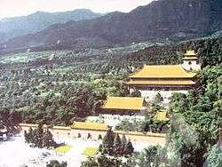
- Ming Dynasty Tombs
- Cloud Platform at Juyong Pass, one of the "three great mountain passes" of the Great Wall of China
- Triathlon Venue for the Triathlon at the 2008 Summer Olympics
- Qincheng Prison of the Ministry of Public Security (near Xiaotangshan)[8]
- Wonderland Amusement Park (Beijing)
Transport
Changping is currently served by four metro lines operated by Beijing Subway and one commuter line operated by BCR:
Metro

Beijing Suburban Railway
Education
Colleges and universities
- The China University of Petroleum (Beijing) is in the district.[9]
- Beida-Changping -- Peiking University at Changping
- Centural University of Finance and Economics
- Beihang University
- China Foreign Affairs University
Primary and secondary schools
Public schools:
- Changping District No. 1 High School (北京市昌平区第一中学)
- Changping District No. 2 High School (北京市昌平区第二中学)
Private schools:
- Beijing Huijia Private School is in Changping District.[10]
- Beijing Royal School
- The Korean International School in Beijing was previously located in Changping District.[11]
Gallery
 Shisanling Reservoir
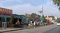 Jiutai Road (九台路) in northern Changping District
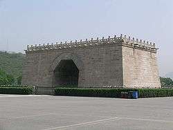
See also
- Changping Railway Station
- Index: Districts of Beijing
- List of administrative divisions of Beijing
References
- ↑ 昌平县志. Beijing Publishing Group. ISBN 9787200066128.
- ↑
- ↑
- ↑ http://www.travelchinaguide.com/images/map/beijing/beijing-subway.gif
- ↑ These towns are officially classified as subdistricts, but as they coincide with the area of the same name, they are commonly named "areas" (地区)
- ↑ 2011年统计用区划代码和城乡划分代码:昌平区 (in Chinese). National Bureau of Statistics of the People's Republic of China. Retrieved 2013-02-23.
- ↑ shi, Guo wu yuan ren kou pu cha ban gong; council, Guo jia tong ji ju ren kou he jiu ye tong ji si bian = Tabulation on the 2010 population census of the people's republic of China by township / compiled by Population census office under the state; population, Department of; statistics, employment statistics national bureau of (2012). Zhongguo 2010 nian ren kou pu cha fen xiang, zhen, jie dao zi liao (Di 1 ban. ed.). Beijing Shi: Zhongguo tong ji chu ban she. ISBN 978-7-5037-6660-2.
- ↑ "秦城:“中国第一监狱”大揭秘(图)." Shanghai Prison. December 31, 2009. Retrieved on February 2, 2011. "秦城监狱位于北京市昌平区小汤山镇附近,[...]"
- ↑ "Home." China University of Petroleum-Beijing. Retrieved on January 17, 2016. "China University of Petroleum-Beijing, 18 Fuxue Road, Changping, Beijing China"
- ↑ "Contact Us Archived 2015-10-04 at the Wayback Machine.." Beijing Huijia Private School. Retrieved on October 3, 2015. "Add.: No.157 Changhuai Road, Changping District, Beijing" Chinese version Archived 2016-01-04 at the Wayback Machine.. "地址: 北京市昌平区昌怀路157号"
- ↑ Home page (Archive). Korean International School in Beijing. January 1, 2006. Retrieved on January 25, 2014. "北京市昌平區7里渠南村531號"
External links
| Wikivoyage has a travel guide for Changping District. |
| Wikimedia Commons has media related to Changping District. |
- Changping District (in simplified Chinese)
| Administration |
|  | ||||||
|---|---|---|---|---|---|---|---|---|
| Education | ||||||||
| Transportation |
| |||||||
| Visitor attractions |
| |||||||
| Municipal agencies |
| |||||||
| ||||||||
Coordinates: 40°13′14.23″N 116°12′37.81″E / 40.2206194°N 116.2105028°E