Felipe Carrillo Puerto Municipality
| Felipe Carrillo Puerto | |||
|---|---|---|---|
| Municipality | |||
 | |||
| |||
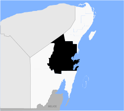 Location within Quintana Roo | |||
|
Felipe Carrillo Puerto Location within Mexico | |||
| Coordinates: 19°35′N 88°03′W / 19.583°N 88.050°WCoordinates: 19°35′N 88°03′W / 19.583°N 88.050°W | |||
| Country | Mexico | ||
| State | Quintana Roo | ||
| Named for | Felipe Carrillo Puerto | ||
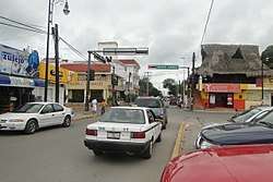
| Municipal seat | Felipe Carrillo Puerto | ||
| Government | |||
| • Municipal President | C. Gabriel Carballo Tadeo | ||
| Area[1] | |||
| • Municipality | 13,806 km2 (5,331 sq mi) | ||
| Elevation | 20 m (70 ft) | ||
| Population (2014) | |||
| • Municipality | 81,742 | ||
| • Density | 5.9/km2 (15/sq mi) | ||
| • Urban | 41,230 | ||
| Demonym(s) | Carrilloportense | ||
| Time zone | UTC-5 (Eastern Standard Time) | ||
| INEGI Code | 23002 | ||
| Website |
www | ||
.png)
Felipe Carrillo Puerto (or simply Carrillo Puerto) is a municipality in the south-central part of the Mexican state of Quintana Roo. The municipal seat is the city of the same name. It was named after the assassinated local politician Felipe Carrillo Puerto. According to the 2014 census, the municipality's population was 81,742 inhabitants, living on an area of 13,806 square kilometres (5,331 sq mi).[2]
The municipality borders Tulum Municipality to the north, Othón P. Blanco to the south, José María Morelos to the west, as well as Valladolid, Chichimilá, and Tixcacalcupul in the state of Yucatán to the northwest.
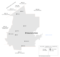
Communities
There were 216 populated localities (localidades) enumerated during the 2010 census, in addition to 167 unpopulated localities. The largest localities (cities, towns, and villages) are:[2]
| Name | Population (2010 census) |
|---|---|
| Felipe Carrillo Puerto | 25,744 |
| Tihosuco | 4,994 |
| Chunhuhub | 4,644 |
| Señor | 3,095 |
| Tepich | 2,753 |
| Noh-Bec | 2,045 |
| X-Hazil Sur | 1,422 |
| X-Pichil | 1,470 |
| Polyuc | 1,226 |
| Dzulá | 1,223 |
| Santa Rosa Segundo | 1,068 |
| Presidente Juárez | 1,004 |
| X-Yatil | 945 |
| Laguna Kaná | 914 |
| Yaxley | 600 |
| Altamirano | 574 |
| Total municipality | 75,026 |
Demographics
| Historical population | ||
|---|---|---|
| Year | Pop. | ±% p.a. |
| 1995 | 56,001 | — |
| 2000 | 60,365 | +1.51% |
| 2005 | 65,373 | +1.61% |
| 2010 | 75,026 | +2.79% |
| Source: INEGI Instituto Nacional de Estadística y Geografía[3] | ||
Archaeological landmarks
Media
XENKA-AM, a government-run indigenous community radio station, is based in Felipe Carrillo Puerto.
References
- ↑ Quintana Roo Archived 2014-10-14 at the Wayback Machine. Enciclopedia de los Municipios de México
- 1 2 2010 census tables: INEGI Archived May 2, 2013, at the Wayback Machine.
- ↑ INEGI. Instituto Nacional de Estadística y Geografía. Censo de Población y Vivienda 1995, 2000, 2005, 2010. Archived 2013-09-28 at the Wayback Machine.
| Wikimedia Commons has media related to Felipe Carrillo Puerto Municipality. |
Chetumal (capital) | |||||||||||
| Municipalities (seats) |
|  | |||||||||
| Places of interest |
| ||||||||||