Puerto Morelos
| Puerto Morelos | |
|---|---|
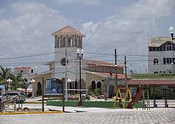 Puerto Morelos plaza | |
|
Puerto Morelos | |
| Coordinates: 20°51′13″N 86°52′31″W / 20.8536°N 86.8753°WCoordinates: 20°51′13″N 86°52′31″W / 20.8536°N 86.8753°W | |
| Country | Mexico |
| State | Quintana Roo |
| Municipality | Puerto Morelos |
| Named for | José María Morelos |
| Government | |
| • Mayor | Francisco Mendoza Reyna |
| Elevation | 4 m (13 ft) |
| Population (2010[1]) | |
| • Total | 9,188 |
| Demonym(s) | Puertomorelense |
| Time zone | UTC-5 (Eastern Standard Time) |
| Postal Code | 77580 |
| Area code(s) | 998 |
| Website |
www |
Puerto Morelos (Spanish pronunciation: ['pweɾto mo'ɾelos]) is a town and seaport in Quintana Roo, Mexico's easternmost state, on the Yucatán Peninsula. The town is located in the northeast of the state, about 36 km south of the resort city of Cancún, and about 30 km north of the city of Playa del Carmen.
Puerto Morelos merged with the village of Leona Vicario on December 6, 2015, to become the 11th municipality in Quintana Roo, separating from its former municipality of Benito Juarez.
The marine terminal at Puerto Morelos is equipped to handle containers and is the oldest, largest and most important seaport in the state of Quintana Roo.
Geography
Puerto Morelos is divided by a highway and a mangrove swamp into three sections. The section west of the highway is known as "Colonia Joaquin Zetina Gazca". The section east of the highway is called "Colonia Pescadores". The section on the coast east of the mangrove swamp is "Puerto" or "Antiguo (old) Puerto Morelos". This original coastal fishing village is now a quiet, mixed-use neighborhood of private homes, hotels, condominiums, restaurants, and tourist shops.
The second part is about 2 km. inland and adjacent to Highway 307, on the western side. The inland portion is mainly single level dwellings for local workers. New residential developments have sprung up in recent years adding to the housing mix. There are now multi-story apartment buildings, and private residential developments between the highway and the mangrove where one can buy lots and build a house of one's own design.
Climate
Classified by Köppen-Geiger system as tropical wet and dry climate (Aw), because its driest month has less than 60 millimetres (2.4 in) of precipitation and also less than 100 − (total annual precipitation [mm]/25), also because each month has a mean average above 18 °C (64 °F).[2]
| Climate data for Puerto Morelos (1951–2010) | |||||||||||||
|---|---|---|---|---|---|---|---|---|---|---|---|---|---|
| Month | Jan | Feb | Mar | Apr | May | Jun | Jul | Aug | Sep | Oct | Nov | Dec | Year |
| Record high °C (°F) | 34.5 (94.1) |
36.5 (97.7) |
38.0 (100.4) |
39.5 (103.1) |
41.5 (106.7) |
40.5 (104.9) |
39.0 (102.2) |
41.0 (105.8) |
41.0 (105.8) |
39.0 (102.2) |
38.0 (100.4) |
35.0 (95) |
41.5 (106.7) |
| Average high °C (°F) | 28.2 (82.8) |
28.6 (83.5) |
29.7 (85.5) |
31.2 (88.2) |
32.3 (90.1) |
32.4 (90.3) |
33.0 (91.4) |
33.3 (91.9) |
32.3 (90.1) |
31.2 (88.2) |
29.7 (85.5) |
28.4 (83.1) |
30.9 (87.6) |
| Daily mean °C (°F) | 23.3 (73.9) |
23.4 (74.1) |
24.8 (76.6) |
26.7 (80.1) |
27.8 (82) |
28.1 (82.6) |
28.4 (83.1) |
28.3 (82.9) |
27.8 (82) |
26.6 (79.9) |
25.0 (77) |
23.7 (74.7) |
26.2 (79.2) |
| Average low °C (°F) | 18.4 (65.1) |
18.2 (64.8) |
20.0 (68) |
22.2 (72) |
23.3 (73.9) |
23.7 (74.7) |
23.8 (74.8) |
23.3 (73.9) |
23.3 (73.9) |
21.9 (71.4) |
20.4 (68.7) |
19.0 (66.2) |
21.5 (70.7) |
| Record low °C (°F) | 5.0 (41) |
6.0 (42.8) |
8.0 (46.4) |
9.0 (48.2) |
12.0 (53.6) |
12.0 (53.6) |
17.0 (62.6) |
12.0 (53.6) |
17.0 (62.6) |
12.0 (53.6) |
10.0 (50) |
9.0 (48.2) |
5.0 (41) |
| Average rainfall mm (inches) | 78.6 (3.094) |
45.2 (1.78) |
42.3 (1.665) |
54.0 (2.126) |
102.0 (4.016) |
138.3 (5.445) |
90.3 (3.555) |
126.7 (4.988) |
187.1 (7.366) |
184.0 (7.244) |
98.8 (3.89) |
74.7 (2.941) |
1,222 (48.11) |
| Average rainy days (≥ 0.1 mm) | 6.4 | 3.9 | 3.1 | 3.2 | 5.4 | 8.9 | 7.8 | 9.8 | 12.9 | 11.8 | 8.7 | 7.0 | 88.9 |
| Source: Servicio Meteorologico Nacional[3][4] | |||||||||||||
History
It has historically been the main port between the mainland of Yucatán and the Island of Cozumel, and an automobile ferry used to run from Puerto Morelos to Cozumel. The town is named after Independence leader José María Morelos.
Resorts are abundant in the Puerto Morelos region along the Riviera Maya and attractions, such as the Crococun Crocodile Zoo, the Botanical Garden, and a host of cenotes are also increasing in number. Recently new smaller inns have been built which offers an evening programs of Talks on local history, marine biology, and healthy living practices.
One hundred meters off shore lies the Puerto Morelos portion of the Mesoamerican Barrier Reef System, designated as a National Marine Park in 1998 due to local environmental activists.
Demographics
Puerto Morelos has grown rapidly with the development of tourism and as of the 2010 census is the home to 9,188 people.[1]
| Population of Puerto Morelos | ||
|---|---|---|
| Year | Pop. | ±% p.a. |
| 1980 | 672 | — |
| 1990 | 740 | +0.97% |
| 1995 | 829 | +2.30% |
| 2000 | 892 | +1.48% |
| 2005 | 1,097 | +4.22% |
| 2010 | 9,188 | +52.97% |
| Source: [5] | ||
Gallery
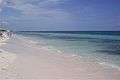 The Beach at Puerto Morelos in Feb. 2007.
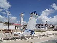 The Puerto Morelos lighthouse tilted by Hurricane Beulah in 1967 is the symbol of the town.
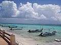 Puerto Morelos Pangas
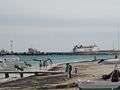 Puerto Morelos Marine Terminal
 Interior of Parroqua San Jose Obero
References
- 1 2 2010 census tables: INEGI Archived 2013-05-02 at the Wayback Machine.
- ↑ Kottek, M., J. Grieser, C. Beck, B. Rudolf, and F. Rubel (2006). "World Map of the Köppen-Geiger climate classification updated" (PDF). Meteorologische Zeitschrift. 15 (3): 259. doi:10.1127/0941-2948/2006/0130. Retrieved 9 July 2013.
- ↑ "Estado de Quintana Roo-Estacion: Puerto Morelos". Normales Climatologicas 1951-2010 (in Spanish). National Meteorological Service of Mexico. Archived from the original on 2015-04-02. Retrieved 9 March 2015.
- ↑ "Extreme Temperatures and Precipitation for Puerto Morelos 1961–1998" (in Spanish). Servicio Meteorológico Nacional. Archived from the original on 2 April 2015. Retrieved 9 March 2015.
- ↑ Instituto Nacional de Estadística y Geografía. "Archivo histórico de localidades". Retrieved 2008-02-04.
External links
| Wikivoyage has a travel guide for Puerto_Morelos. |

- Puerto Morelos National Marine Park
Chetumal (capital) | |||||||||||
| Municipalities (seats) |
|  | |||||||||
| Places of interest |
| ||||||||||