Xcalak
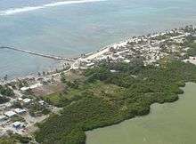
Xcalak is a village of 375 inhabitants[1] in the municipality of Othón P. Blanco, Quintana Roo, on the Caribbean coast of Mexico. It is one of the last "unspoiled" stretches of Mexican Caribbean located on the southern end of the Costa Maya. The world's second largest barrier reef passes just off-shore from Xcalak and it is also a departure point for dive trips to the Chinchorro Banks (Banco Chinchorro) atoll reef system. It is designated a Mexican national reef park (Parque Nacional Arrecifes de Xcalak) and is an excellent site for snorkeling, scuba diving and fly fishing. It is 60 kilometers (37 mi) south of Mahahual, the site of a new large cruise ship pier, and just north of the border with Belize. The Mahahual pier was destroyed by hurricane Dean in 2007. This section of coast is now being developed by the tourism industry and has a growing number of Americans and other expatriates investing in beach front property north of town. However, development is nowhere close to the degree of development of its Northern cities Cancún and Playa del Carmen.
History
The first settlements in the region date from the Pre-Columbian era. Nearby are the ruins of the Mayan city of Xcalak, where the name of the town comes from.
In May 1900, the Mexican Navy established the villa of Xcalak as a control post of the zone. There the first shipyard of the Mexican Caribbean was constructed.
During the twentieth century, the area became a major population area, with a significant production of coconut from coco palm plantations that reached up to 300 tons monthly. In 1955, the city was whipped by Hurricane Janet that destroyed a great part of the town and scattered the population to other areas.
Climate
Xcalak was the largest city in Quintana Roo until it was destroyed by Hurricane Janet in 1955. Hurricane Dean struck Majahual, only 50 kilometers north of Xcalak in 2007.
| Climate data for Xcalak | |||||||||||||
|---|---|---|---|---|---|---|---|---|---|---|---|---|---|
| Month | Jan | Feb | Mar | Apr | May | Jun | Jul | Aug | Sep | Oct | Nov | Dec | Year |
| Average high °C (°F) | 28 (82.4) |
28 (82.4) |
29.5 (85.1) |
30.8 (87.4) |
31.7 (89.1) |
31.5 (88.7) |
31.7 (89.1) |
31.8 (89.2) |
31.5 (88.7) |
30.6 (87.1) |
29.1 (84.4) |
27.9 (82.2) |
30.2 (86.4) |
| Average low °C (°F) | 21 (70) |
21.3 (70.3) |
22.6 (72.7) |
23.6 (74.5) |
24.5 (76.1) |
24.3 (75.7) |
24.6 (76.3) |
24.5 (76.1) |
24.4 (75.9) |
22.9 (73.2) |
21.9 (71.4) |
20.8 (69.4) |
23 (73.4) |
| Average precipitation mm (inches) | 81 (3.2) |
30 (1.2) |
13 (0.5) |
33 (1.3) |
58 (2.3) |
150 (6) |
74 (2.9) |
91 (3.6) |
185 (7.3) |
157 (6.2) |
145 (5.7) |
109 (4.3) |
1,133 (44.6) |
| Source: Weatherbase [2] | |||||||||||||
External links
| Wikimedia Commons has media related to Xcalak. |

References
- ↑ 2010 census tables: INEGI Archived May 2, 2013, at the Wayback Machine.
- ↑ "Weatherbase: Historical Weather for Xcalak, Quintana Roo". Weatherbase. 2011. Retrieved on November 24, 2011.
Coordinates: 18°16′17″N 87°50′09″W / 18.27139°N 87.83583°W
Chetumal (capital) | |||||||||||
| Municipalities (seats) |
|  | |||||||||
| Places of interest |
| ||||||||||