Fairfield Township, Cumberland County, New Jersey
| Fairfield Township, New Jersey | |
|---|---|
| Township | |
| Township of Fairfield | |
 | |
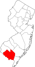
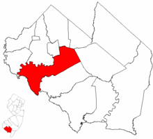 Fairfield Township highlighted in Cumberland County. Inset map: Cumberland County highlighted in the State of New Jersey. | |
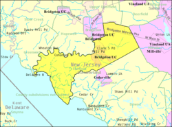 Census Bureau map of Fairfield Township, Cumberland County, New Jersey | |
| Coordinates: 39°22′20″N 75°14′19″W / 39.372316°N 75.238721°WCoordinates: 39°22′20″N 75°14′19″W / 39.372316°N 75.238721°W[1][2] | |
| Country |
|
| State |
|
| County | Cumberland |
| Formed | May 12, 1697 |
| Incorporated | February 21, 1798 |
| Named for | Fairfield, Connecticut |
| Government[3] | |
| • Type | Township |
| • Body | Township Committee |
| • Mayor | Benjamin Byrd Sr. (D, term ends December 31, 2017)[4][5] |
| • Administrator | Jack Surrency[6] |
| • Municipal clerk | Linda M. Gonzales[6] |
| Area[1] | |
| • Total | 43.950 sq mi (113.830 km2) |
| • Land | 41.260 sq mi (106.864 km2) |
| • Water | 2.690 sq mi (6.966 km2) 6.12% |
| Area rank |
45th of 566 in state 5th of 14 in county[1] |
| Elevation[7] | 16 ft (5 m) |
| Population (2010 Census)[8][9][10] | |
| • Total | 6,295 |
| • Estimate (2016)[11] | 6,163 |
| • Rank |
335th of 566 in state 6th of 14 in county[12] |
| • Density | 152.6/sq mi (58.9/km2) |
| • Density rank |
522nd of 566 in state 9th of 14 in county[12] |
| Time zone | UTC-5 (Eastern (EST)) |
| • Summer (DST) | UTC-4 (Eastern (EDT)) |
| ZIP code | 08320 - Fairton[13][14] |
| Area code(s) | 856 exchange: 575[15] |
| FIPS code | 3401122350[1][16][17] |
| GNIS feature ID | 0882059[1][18] |
| Website |
www |
Fairfield Township is a township in Cumberland County, New Jersey, United States. It is part of the Vineland-Millville- Bridgeton Primary Metropolitan Statistical Area for statistical purposes. As of the 2010 United States Census, the township's population was 6,295,[8][9][10] reflecting an increase of 12 (+0.2%) from the 6,283 counted in the 2000 Census, which had in turn increased by 584 (+10.2%) from the 5,699 counted in the 1990 Census.[19]
Fairfield Township was formed by Royal charter on May 12, 1697, from portions of the Cohansey Township area, while still part of Salem County, and was formed as a precinct in the newly created Cumberland County on January 19, 1748. It was incorporated on February 21, 1798, as one of the initial group of 104 townships in the state by an act of the New Jersey Legislature. Portions of the township were taken to form Downe Township (September 26, 1772), Millville Township (February 24, 1801) and Lawrence Township (February 17, 1885).[20]
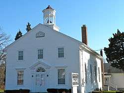
The name Fairfield refers to its original settlers, who were émigrés from Fairfield, Connecticut.[21] The oldest Presbyterian church in South Jersey is said to date from before 1697. There is a plaque and an old cemetery which indicates the original log building.[22]
Geography
According to the United States Census Bureau, the township had a total area of 43.950 square miles (113.830 km2), including 41.260 square miles (106.864 km2) of land and 2.690 square miles (6.966 km2) of water (6.12%).[1][2]
Fairton (with a 2010 Census population of 1,264[23]) is an unincorporated community and census-designated place (CDP) located within Fairfield Township.[24]
Other unincorporated communities, localities and place names located partially or completely within the township include Back Neck, Ben Davis Point, Clarks Pond, Fordville, Gouldtown, Lanings Wharf, Mulfords Landing, New England Crossroads and Sea Breeze and Tindells Landing.[25]
The township has three primary population centers: Sea Breeze, Fairton (originally named Bumbridge) and Gouldtown, an old African American community from the segregation period.[22][26]
Fairfield Township borders Lawrence Township, Millville, Deerfield Township, Upper Deerfield Township, Bridgeton, Hopewell Township, Greenwich Township, and the Delaware Bay.
Demographics
| Historical population | |||
|---|---|---|---|
| Census | Pop. | %± | |
| 1810 | 2,279 | * | — |
| 1820 | 1,869 | −18.0% | |
| 1830 | 1,812 | −3.0% | |
| 1840 | 1,935 | 6.8% | |
| 1850 | 2,133 | 10.2% | |
| 1860 | 2,448 | 14.8% | |
| 1870 | 3,011 | 23.0% | |
| 1880 | 3,215 | 6.8% | |
| 1890 | 1,688 | * | −47.5% |
| 1900 | 1,911 | 13.2% | |
| 1910 | 1,629 | −14.8% | |
| 1920 | 1,514 | −7.1% | |
| 1930 | 1,848 | 22.1% | |
| 1940 | 1,977 | 7.0% | |
| 1950 | 2,932 | 48.3% | |
| 1960 | 3,916 | 33.6% | |
| 1970 | 4,990 | 27.4% | |
| 1980 | 5,693 | 14.1% | |
| 1990 | 5,699 | 0.1% | |
| 2000 | 6,283 | 10.2% | |
| 2010 | 6,295 | 0.2% | |
| Est. 2016 | 6,163 | [11][27] | −2.1% |
| Population sources: 1810-2000[28] 1810-1920[29] 1840[30] 1850-1870[31] 1850[32] 1870[33] 1880-1890[34] 1890-1910[35] 1910-1930[36] 1930-1990[37] 2000[38][39] 2010[8][9][10] * = Lost territory in previous decade[20] | |||
Census 2010
As of the 2010 United States Census, there were 6,295 people, 1,882 households, and 1,357 families residing in the township. The population density was 152.6 per square mile (58.9/km2). There were 2,058 housing units at an average density of 49.9 per square mile (19.3/km2). The racial makeup of the township was 37.49% (2,360) White, 47.53% (2,992) Black or African American, 5.10% (321) Native American, 0.44% (28) Asian, 0.03% (2) Pacific Islander, 4.58% (288) from other races, and 4.83% (304) from two or more races. Hispanic or Latino of any race were 12.84% (808) of the population.[8]
There were 1,882 households out of which 24.6% had children under the age of 18 living with them, 43.6% were married couples living together, 21.3% had a female householder with no husband present, and 27.9% were non-families. 24.1% of all households were made up of individuals, and 9.9% had someone living alone who was 65 years of age or older. The average household size was 2.67 and the average family size was 3.14.[8]
In the township, the population was spread out with 17.8% under the age of 18, 9.2% from 18 to 24, 32.5% from 25 to 44, 27.3% from 45 to 64, and 13.2% who were 65 years of age or older. The median age was 39.0 years. For every 100 females there were 139.4 males. For every 100 females ages 18 and older there were 148.8 males.[8]
Fairfield Township had the highest percentage of Native Americans in any municipality in New Jersey, at 5.10% in the 2010 Census.
The Census Bureau's 2006-2010 American Community Survey showed that (in 2010 inflation-adjusted dollars) median household income was $46,895 (with a margin of error of +/- $3,014) and the median family income was $55,286 (+/- $4,900). Males had a median income of $45,333 (+/- $4,287) versus $32,763 (+/- $2,703) for females. The per capita income for the borough was $20,619 (+/- $1,444). About 6.7% of families and 10.3% of the population were below the poverty line, including 17.1% of those under age 18 and 4.3% of those age 65 or over.[40]
Census 2000
As of the 2000 United States Census[16] there were 6,283 people, 1,751 households, and 1,322 families residing in the township. The population density was 148.6 people per square mile (57.4/km2). There were 1,915 housing units at an average density of 45.3 per square mile (17.5/km2). The racial makeup of the township was 41.41% White, 47.43% African American, 5.08% Native American, 0.56% Asian, 0.03% Pacific Islander, 2.39% from other races, and 3.10% from two or more races. Hispanic or Latino of any race were 8.87% of the population.[38][39]
There were 1,751 households out of which 28.2% had children under the age of 18 living with them, 50.7% were married couples living together, 18.5% had a female householder with no husband present, and 24.5% were non-families. 20.4% of all households were made up of individuals and 8.1% had someone living alone who was 65 years of age or older. The average household size was 2.78 and the average family size was 3.19.[38][39]
In the township the population was spread out with 19.8% under the age of 18, 8.8% from 18 to 24, 36.4% from 25 to 44, 24.3% from 45 to 64, and 10.7% who were 65 years of age or older. The median age was 37 years. For every 100 females, there were 146.7 males. For every 100 females age 18 and over, there were 161.7 males.[38][39]
The median income for a household in the township was $37,891, and the median income for a family was $41,326. Males had a median income of $31,858 versus $23,931 for females. The per capita income for the township was $17,547. About 6.9% of families and 11.2% of the population were below the poverty line, including 14.9% of those under age 18 and 7.8% of those age 65 or over.[38][39]
Government
Local government
Fairfield Township is governed under the Township form of government. The five-member Township Committee is elected directly by the voters at-large in partisan elections to serve three-year terms of office on a staggered basis, with either one or two seats coming up for election each year as part of the November general election in a three-year cycle.[3][41] At an annual reorganization meeting, the Township Committee selects one of its members to serve as Mayor and another as Deputy Mayor.
As of 2016, members of the Fairfield Township Committee are Mayor Benjamin Byrd Sr. (D, term on committee and as mayor ends December 31, 2016; term as deputy mayor ends 2015), Deputy Mayor Tommy Clark Jr. (D, term on committee ends 2017; term as deputy mayor ends 2016), Bernard A. Manson (I, 2018) and Marvin Pierce Jr. (D, 2018), with the seat formerly held by Troy Pitts being vacant.[4][42][43][44][45][46]
JoAnne Servais was appointed to serve the unexpired term ending December 2014 of Dennis Pierce, who had resigned from office in June 2012 citing health issues.[47][48]
Federal, state and county representation
Fairfield Township is located in the 2nd Congressional District[49] and is part of New Jersey's 1st state legislative district.[9][50][51] Prior to the 2011 reapportionment following the 2010 Census, Fairfield Township had been in the 3rd state legislative district.[52]
New Jersey's Second Congressional District is represented by Frank LoBiondo (R, Ventnor City).[53] New Jersey is represented in the United States Senate by Democrats Cory Booker (Newark, term ends 2021)[54] and Bob Menendez (Paramus, 2019).[55][56]
For the 2018–2019 session (Senate, General Assembly), the 1st Legislative District of the New Jersey Legislature is represented in the State Senate by Jeff Van Drew (D, Dennis Township) and in the General Assembly by Bob Andrzejczak (D, Middle Township) and R. Bruce Land (D, Vineland).[57][58] The Governor of New Jersey is Phil Murphy (D, Middletown Township).[59] The Lieutenant Governor of New Jersey is Sheila Oliver (D, East Orange).[60]
Cumberland County is governed by a seven-member Board of Chosen Freeholders, who are elected at-large in partisan elections to serve staggered three-year terms in office, with either two or three seats coming up for election each year in a three-year cycle. At an annual reorganization meeting held each January, the freeholders select one member to serve as Freeholder Director and another as Deputy Director.[61] As of 2018, Cumberland County's Freeholders are Freeholder Director Joseph Derella Jr. (D, Millville, term as freeholder and as freeholder director ends December 31, 2018),[62] Deputy Freeholder Director Darlene R. Barber (D, Upper Deerfield Township, term as freeholder ends 2019, term as deputy freeholder director ends 2018),[63] George Castellini (D, Vineland, 2020),[64] Carol Musso (D, Deerfield Township, 2020),[65] James F. Quinn (D, Millville, 2018),[66] Joseph V. Sparacio (R, Deerfield Township, 2019)[67] and Jack Surrency (D, Bridgeton 2020).[68][69][70][71] The county's constitutional officers are Clerk Celeste Riley (D, Bridgeton, 2019),[72][73] Sheriff Robert A. Austino (D, Vineland, 2020)[74][75] and Surrogate Douglas M. Rainear (D, Upper Deerfield Township, 2018).[76][77][70]
Politics
As of March 23, 2011, there were a total of 3,639 registered voters in Fairfield Township, of which 1,603 (44.1%) were registered as Democrats, 409 (11.2%) were registered as Republicans and 1,627 (44.7%) were registered as Unaffiliated. There were no voters registered to other parties.[78]
In the 2012 presidential election, Democrat Barack Obama received 76.9% of the vote (1,830 cast), ahead of Republican Mitt Romney with 22.4% (534 votes), and other candidates with 0.6% (15 votes), among the 2,405 ballots cast by the township's 3,739 registered voters (26 ballots were spoiled), for a turnout of 64.3%.[79][80] In the 2008 presidential election, Democrat Barack Obama received 75.9% of the vote (1,860 cast), ahead of Republican John McCain, who received 22.3% (547 votes), with 2,451 ballots cast among the township's 3,707 registered voters, for a turnout of 66.1%.[81] In the 2004 presidential election, Democrat John Kerry received 68.7% of the vote (1,476 ballots cast), outpolling Republican George W. Bush, who received around 29.6% (636 votes), with 2,149 ballots cast among the township's 3,400 registered voters, for a turnout percentage of 63.2.[82]
In the 2013 gubernatorial election, Democrat Barbara Buono received 61.0% of the vote (774 cast), ahead of Republican Chris Christie with 37.2% (472 votes), and other candidates with 1.7% (22 votes), among the 1,315 ballots cast by the township's 3,584 registered voters (47 ballots were spoiled), for a turnout of 36.7%.[83][84] In the 2009 gubernatorial election, Democrat Jon Corzine received 65.% of the vote (925 ballots cast), ahead of both Republican Chris Christie with 27.2% (387 votes) and Independent Chris Daggett with 3.9% (56 votes), with 1,424 ballots cast among the township's 3,586 registered voters, yielding a 39.7% turnout.[85]
Education
The Fairfield Township School District serves public school students in pre-kindergarten through eighth grade. The district opened the new Fairfield Township School in September 2006, consolidating all grades into a single building located at 375 Gouldtown-Woodruff Road in the Gouldtown section of the township.[86] As of the 2014-15 school year, the district and its one school had an enrollment of 909 students and 53.0 classroom teachers (on an FTE basis), for a student–teacher ratio of 17.2:1.[87]
Public school students in ninth through twelfth grades attend Cumberland Regional High School, which also serves students from Deerfield Township, Greenwich Township, Hopewell Township, Shiloh Borough, Stow Creek Township and Upper Deerfield Township.[88][89][90] As of the 2014-15 school year, the high school had an enrollment of 1,354 students and 87.9 classroom teachers (on an FTE basis), for a student–teacher ratio of 15.4:1.[91]
Transportation
Roads and highways
As of May 2010, the township had a total of 74.45 miles (119.82 km) of roadways, of which 30.89 miles (49.71 km) were maintained by the municipality, 39.90 miles (64.21 km) by Cumberland County and 3.66 miles (5.89 km) by the New Jersey Department of Transportation.[92]
Public transportation
NJ Transit offers service on the 553 route between Upper Deerfield Township and Atlantic City.[93]
Notable people
People who were born in, residents of, or otherwise closely associated with Fairfield Township include:
- Nathaniel Clark Burt (1825-1874), Presbyterian clergyman.[94]
- Harold Gould (1924-2012), baseball pitcher with the Philadelphia Stars in the Negro leagues from 1947 to 1948.[95][96]
- John T. Nixon (1820–1889), represented New Jersey's 1st congressional district in the United States House of Representatives from 1859 to 1863.[97]
- Theophilus Gould Steward (1843-1924), author, educator, and clergyman, who was a U.S. Army chaplain and Buffalo Soldier of 25th U.S. Colored Infantry.[98]
References
- 1 2 3 4 5 6 2010 Census Gazetteer Files: New Jersey County Subdivisions, United States Census Bureau. Accessed May 21, 2015.
- 1 2 US Gazetteer files: 2010, 2000, and 1990, United States Census Bureau. Accessed September 4, 2014.
- 1 2 2012 New Jersey Legislative District Data Book, Rutgers University Edward J. Bloustein School of Planning and Public Policy, March 2013, p. 19.
- 1 2 Township Directory Township Committee, Fairfield Township. Accessed June 21, 2015.
- ↑ 2017 New Jersey Mayors Directory, New Jersey Department of Community Affairs. Accessed May 30, 2017.
- 1 2 Township Directory, Fairfield Township. Accessed June 30, 2016.
- ↑ U.S. Geological Survey Geographic Names Information System: Township of Fairfield, Geographic Names Information System. Accessed March 5, 2013.
- 1 2 3 4 5 6 DP-1 - Profile of General Population and Housing Characteristics: 2010 for Fairfield township, Cumberland County, New Jersey, United States Census Bureau. Accessed October 22, 2012.
- 1 2 3 4 Municipalities Grouped by 2011-2020 Legislative Districts, New Jersey Department of State, p. 1. Accessed January 6, 2013.
- 1 2 3 Profile of General Demographic Characteristics: 2010 for Fairfield township, New Jersey Department of Labor and Workforce Development. Accessed October 22, 2012.
- 1 2 PEPANNRES - Annual Estimates of the Resident Population: April 1, 2010 to July 1, 2016 - 2016 Population Estimates for New Jersey municipalities, United States Census Bureau. Accessed June 16, 2017.
- 1 2 GCT-PH1 Population, Housing Units, Area, and Density: 2010 - State -- County Subdivision from the 2010 Census Summary File 1 for New Jersey, United States Census Bureau. Accessed October 22, 2012.
- ↑ Look Up a ZIP Code for Fairton, NJ, United States Postal Service. Accessed October 22, 2012.
- ↑ Zip Codes, State of New Jersey. Accessed September 8, 2013.
- ↑ Area Code Lookup - NPA NXX for Fairton, NJ, Area-Codes.com. Accessed September 8, 2013.
- 1 2 American FactFinder, United States Census Bureau. Accessed September 4, 2014.
- ↑ A Cure for the Common Codes: New Jersey, Missouri Census Data Center. Accessed October 22, 2012.
- ↑ US Board on Geographic Names, United States Geological Survey. Accessed September 4, 2014.
- ↑ Table 7. Population for the Counties and Municipalities in New Jersey: 1990, 2000 and 2010, New Jersey Department of Labor and Workforce Development, February 2011. Accessed October 22, 2012.
- 1 2 Snyder, John P. The Story of New Jersey's Civil Boundaries: 1606-1968, Bureau of Geology and Topography; Trenton, New Jersey; 1969. p. 120. Accessed October 22, 2012.
- ↑ Hutchinson, Viola L. The Origin of New Jersey Place Names, New Jersey Public Library Commission, May 1945. Accessed August 30, 2015.
- 1 2 Laurie, Maxine N.; and Mappen, Marc; "Fairfield", Encyclopedia of New Jersey, p. 264. Rutgers University Press; 2004/2005. ISBN 9780813533254. Accessed September 8, 2013.
- ↑ DP-1 - Profile of General Population and Housing Characteristics: 2010 Demographic Profile Data for Fairton CDP, New Jersey, United States Census Bureau. Accessed October 21, 2012.
- ↑ New Jersey: 2010 - Population and Housing Unit Counts - 2010 Census of Population and Housing (CPH-2-32), United States Census Bureau, August 2012. Accessed October 22, 2012.
- ↑ Locality Search, State of New Jersey. Accessed May 21, 2015.
- ↑ O'Brien, Gina. "FAIRFIELD RESIDENTS SET TO CELEBRATE TOWNSHIP'S RICH HISTORY", The Press of Atlantic City, September 28, 1997. Accessed October 22, 2012.
- ↑ Census Estimates for New Jersey April 1, 2010 to July 1, 2016, United States Census Bureau. Accessed June 16, 2017.
- ↑ Barnett, Bob. Population Data for Cumberland County Municipalities, 1810 - 2010, WestJersey.org. January 6, 2011. Accessed October 22, 2012.
- ↑ Compendium of censuses 1726-1905: together with the tabulated returns of 1905, New Jersey Department of State, 1906. Accessed July 10, 2013.
- ↑ Bowen, Francis. American Almanac and Repository of Useful Knowledge for the Year 1843, p. 232, David H. Williams, 1842. Accessed September 8, 2013.
- ↑ Raum, John O. The History of New Jersey: From Its Earliest Settlement to the Present Time, Volume 1, p. 269, J. E. Potter and company, 1877. Accessed September 8, 2013. "Fairfield was settled principally by emigrants, from the town in Connecticut of the same name. Its population in 1850 was 2,133; in 1860, 2,448; and in 1870, 3,011. Cedarville, Gouldtown, and Fairton, are post towns in this township."
- ↑ Debow, James Dunwoody Brownson. The Seventh Census of the United States: 1850, p. 138. R. Armstrong, 1853. Accessed September 8, 2013.
- ↑ Staff. A compendium of the ninth census, 1870, p. 258. United States Census Bureau, 1872. Accessed September 8, 2013.
- ↑ Porter, Robert Percival. Preliminary Results as Contained in the Eleventh Census Bulletins: Volume III - 51 to 75, p. 97. United States Census Bureau, 1890. Accessed September 8, 2013.
- ↑ Thirteenth Census of the United States, 1910: Population by Counties and Minor Civil Divisions, 1910, 1900, 1890, United States Census Bureau, p. 336. Accessed October 22, 2012.
- ↑ Fifteenth Census of the United States : 1930 - Population Volume I, United States Census Bureau, p. 715. Accessed October 22, 2012.
- ↑ New Jersey Resident Population by Municipality: 1930 - 1990, Workforce New Jersey Public Information Network. Accessed June 28, 2015.
- 1 2 3 4 5 Census 2000 Profiles of Demographic / Social / Economic / Housing Characteristics for Fairfield township, Cumberland County, New Jersey, United States Census Bureau. Accessed October 22, 2012.
- 1 2 3 4 5 DP-1: Profile of General Demographic Characteristics: 2000 - Census 2000 Summary File 1 (SF 1) 100-Percent Data for Fairfield township, Cumberland County, New Jersey, United States Census Bureau. Accessed October 22, 2012.
- ↑ DP03: Selected Economic Characteristics from the 2006-2010 American Community Survey 5-Year Estimates for Fairfield township, Cumberland County, New Jersey, United States Census Bureau. Accessed October 22, 2012.
- ↑ "Forms of Municipal Government in New Jersey", p. 7. Rutgers University Center for Government Studies. Accessed June 3, 2015.
- ↑ 2016 Municipal Data Sheet, Fairfield Township. Accessed June 30, 2016.
- ↑ 2016 Directory of Cumberland County, New Jersey, Cumberland County, New Jersey. Accessed June 30, 2016.
- ↑ Cumberland County GENERAL - November 3rd, 2015 Official Results, Cumberland County, New Jersey, updated November 3, 2015. Accessed June 30, 2016.
- ↑ Cumberland County General - November 4, 2014 Official Results, Cumberland County, New Jersey, updated March 17, 2015. Accessed June 30, 2016.
- ↑ Cumberland County General - November 5, 2013 Unofficial Results, Cumberland County, New Jersey, updated November 6, 2013. Accessed June 30, 2016.
- ↑ Woods, Don E. "Democrats win committee seats in Fairfield Township", South Jersey Times, November 6, 2012. Accessed June 23, 2014. "Results for Fairfield's highly contested committee seats are in, with Michael Morton and JoAnne Servais winning the three-year seats and Viola Thomas Hughes winning the unexpired seat.... Servais, who became incumbent after Dennis Pierce stepped down for health reasons."
- ↑ Woods, Don E. "Fairfield Township committeeman steps down for health reasons", South Jersey Times, June 13, 2012. Accessed June 23, 2014. "Dennis Pierce officially submitted his resignation on Monday, June 11. Pierce, who took the oath of office on Jan. 5, resigned only six months into his three year term."
- ↑ Plan Components Report, New Jersey Redistricting Commission, December 23, 2011. Accessed January 6, 2013.
- ↑ 2017 New Jersey Citizen's Guide to Government, p. 57, New Jersey League of Women Voters. Accessed May 30, 2017.
- ↑ Districts by Number for 2011-2020, New Jersey Legislature. Accessed January 6, 2013.
- ↑ 2011 New Jersey Citizen's Guide to Government, p. 57, New Jersey League of Women Voters. Accessed May 22, 2015.
- ↑ Directory of Representatives: New Jersey, United States House of Representatives. Accessed January 5, 2012.
- ↑ About Cory Booker, United States Senate. Accessed January 26, 2015. "He now owns a home and lives in Newark's Central Ward community."
- ↑ Biography of Bob Menendez, United States Senate, January 26, 2015. "He currently lives in Paramus and has two children, Alicia and Robert."
- ↑ Senators of the 114th Congress from New Jersey. United States Senate. Accessed January 26, 2015. "Booker, Cory A. - (D - NJ) Class II; Menendez, Robert - (D - NJ) Class I"
- ↑ Legislative Roster 2018-2019 Session, New Jersey Legislature. Accessed January 21, 2018.
- ↑ District 1 Legislators, New Jersey Legislature. Accessed January 22, 2018.
- ↑ Governor Phil Murphy, State of New Jersey. Accessed January 16, 2018.
- ↑ Lieutenant Governor Oliver, State of New Jersey. Accessed January 16, 2018. "Assemblywoman Oliver has resided in the City of East Orange for over 40 years."
- ↑ About Cumberland County Government, Cumberland County, New Jersey. Accessed June 7, 2018. "By law, Cumberland County is allowed 7 freeholders, who serve staggered, overlapping three year terms. Two are elected in two successive years, three in the third year, elected from the county at-large. A Director of the Board is selected by his colleagues for a one year term."
- ↑ Joseph Derella, Cumberland County, New Jersey. Accessed June 7, 2018.
- ↑ Darlene Barber, Cumberland County, New Jersey. Accessed June 7, 2018.
- ↑ George Castellini, Cumberland County, New Jersey. Accessed June 7, 2018.
- ↑ Carol Musso, Cumberland County, New Jersey. Accessed June 7, 2018.
- ↑ James F. Quinn, Cumberland County, New Jersey. Accessed June 7, 2018.
- ↑ Joseph V. Sparacio, Cumberland County, New Jersey. Accessed June 7, 2018.
- ↑ Jack Surrency, Cumberland County, New Jersey. Accessed June 7, 2018.
- ↑ The Cumberland County Board of Chosen Freeholders, Cumberland County, New Jersey. Accessed June 7, 2018.
- 1 2 2018 Directory of Cumberland County, New Jersey, Cumberland County, New Jersey. Accessed June 7, 2018.
- ↑ 2018 County Data Sheet, Cumberland County, New Jersey. Accessed June 7, 2018.
- ↑ County Clerk: Celeste M. Riley, Cumberland County Clerk's Office. Accessed June 7, 2018.
- ↑ Members List: Clerks, Constitutional Officers Association of New Jersey. Accessed June 7, 2018.
- ↑ Sheriff's Office, Cumberland County, New Jersey. Accessed June 7, 2018.
- ↑ Members List: Sheriffs, Constitutional Officers Association of New Jersey. Accessed June 7, 2018.
- ↑ Cumberland County Surrogate Office, Cumberland County, New Jersey. Accessed June 7, 2018.
- ↑ Members List: Surrogates, Constitutional Officers Association of New Jersey. Accessed June 7, 2018.
- ↑ Voter Registration Summary - Cumberland, New Jersey Department of State Division of Elections, March 23, 2011. Accessed October 23, 2012.
- ↑ "Presidential General Election Results - November 6, 2012 - Cumberland County" (PDF). New Jersey Department of Elections. March 15, 2013. Retrieved December 24, 2014.
- ↑ "Number of Registered Voters and Ballots Cast - November 6, 2012 - General Election Results - Cumberland County" (PDF). New Jersey Department of Elections. March 15, 2013. Retrieved December 24, 2014.
- ↑ 2008 Presidential General Election Results: Cumberland County, New Jersey Department of State Division of Elections, December 23, 2008. Accessed October 23, 2012.
- ↑ 2004 Presidential Election: Cumberland County, New Jersey Department of State Division of Elections, December 13, 2004. Accessed October 23, 2012.
- ↑ "Governor - Cumberland County" (PDF). New Jersey Department of Elections. January 29, 2014. Retrieved December 24, 2014.
- ↑ "Number of Registered Voters and Ballots Cast - November 5, 2013 - General Election Results - Cumberland County" (PDF). New Jersey Department of Elections. January 29, 2014. Retrieved December 24, 2014.
- ↑ 2009 Governor: Cumberland County, New Jersey Department of State Division of Elections, December 31, 2009. Accessed October 23, 2012.
- ↑ "SCC, Fairfield Educators Open New Elementary School", New Jersey Schools Development Authority, December 16, 2006. Accessed September 10, 2014. "Students, teachers and parents in this rural Cumberland County community turned out today for a ribbon-cutting for the new Fairfield Elementary School. The school, which replaces two overcrowded facilities, will enhance academic achievement and provide much-needed early childhood education programs for 600 students from pre-kindergarten through 8th grade."
- ↑ District information for Fairfield Township School District, National Center for Education Statistics. Accessed December 7, 2016.
- ↑ Cumberland Regional School District 2015 Report Card Narrative, New Jersey Department of Education. Accessed June 5, 2016. "The Cumberland Regional School District, located in Western Cumberland County, provides students with a comprehensive learning environment in a nurturing and personalized setting. The district serves students in grades 9-12 who reside in the municipalities of Deerfield, Fairfield, Greenwich & Stow Creek, Hopewell & Shiloh, and Upper Deerfield."
- ↑ Shott, Meghan. "Cumberland Regional High School", South Jersey magazine. Accessed June 5, 2016. "Cumberland Regional High School, located in the northwest part of Cumberland County, serves students from Deerfield Township, Fairfield Township, Greenwich Township, Hopewell Township, Shiloh Borough, Stow Creek Township and Upper Deerfield Township."
- ↑ Constituent Districts, Cumberland Regional High School. Accessed June 5, 2016.
- ↑ School data for Cumberland Regional High School, National Center for Education Statistics. Accessed December 12, 2016.
- ↑ Cumberland County Mileage by Municipality and Jurisdiction, New Jersey Department of Transportation, May 2010. Accessed July 18, 2014.
- ↑ South Jersey Transit Guide, Cross County Connection, as of April 1, 2010. Accessed December 15, 2014.
- ↑ Brown, John Howard (ed.) Lamb's Biographical Dictionary of the United States, Volume 1, p. 514. Accessed December 29, 2016. "BURT, Nathaniel Clark, clergyman, was born in Fairton, N. J., April 23, 1825."
- ↑ Harold Gould, Negro Leagues Baseball Museum. Accessed December 29, 2016. "Born: September 29, 1924, Gouldtown-Fairfield Township, New Jersey"
- ↑ Goldstein, Eric. "Harold Gould, former Negro Leagues player and South Jersey native, dies at age 88", South Jersey Times, November 12, 2012. Accessed December 29, 2012. "Born and raised in Gouldtown, Mr. Gould pitched for the Stars in from 1946-1948."
- ↑ John Thompson Nixon, Biographical Directory of the United States Congress. Accessed August 24, 2007.
- ↑ Seraile, William. "Theophilus G. Steward, Intellectual Chaplain, 25th US Colored Infantry", Nebraska State Historical Society. Accessed December 29, 2016. "Born on April 17, 1843, to James and Rebecca Steward, Theophilus grew up in Gouldtown, a southern New Jersey community that dated to pre-Revolutionary War days."
External links
- Fairfield Township web site
- Cumberland County web page for Fairfield Township
- Fairfield Township School District
- Cumberland County web page for the Fairfield Township School District
- Fairfield Township School District's 2015–16 School Report Card from the New Jersey Department of Education
- School Data for the Fairfield Township School District, National Center for Education Statistics
- Cumberland Regional High School