Buckshutem, New Jersey
| Buckshutem, New Jersey | |
|---|---|
| Unincorporated community | |
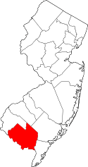
 Buckshutem Location in Cumberland County (Inset: Cumberland County in New Jersey)  Buckshutem Buckshutem (New Jersey)  Buckshutem Buckshutem (the US) | |
| Coordinates: 39°19′08″N 75°00′46″W / 39.31889°N 75.01278°W | |
| Country |
|
| State |
|
| County | Cumberland |
| Township | Commercial |
| Elevation | 6 m (20 ft) |
| Time zone | UTC-5 (Eastern (EST)) |
| • Summer (DST) | UTC-4 (Eastern (EDT)) |
| Area code(s) | 856 |
| GNIS feature ID | 875011[1] |
Buckshutem is an unincorporated community located within Commercial Township, in Cumberland County, New Jersey, United States.[2] The community is situated near Buckshutem Creek, nearby Laurel Lake. The name "Buckshutem" is of Native American origin; though others say that the name is derived from the creek's rapid flow of water as it empties into the brisk wake of the Maurice River, producing a cross current that causes a boat to "buck and shoot" through that section.[3]
References
- ↑ U.S. Geological Survey Geographic Names Information System: Buckshutem, New Jersey
- ↑ Locality Search, State of New Jersey. Accessed June 9, 2016.
- ↑ Debra A. Barsotti. "Maurice River Recollections Project". Citizens United. Retrieved July 8, 2012.
This article is issued from
Wikipedia.
The text is licensed under Creative Commons - Attribution - Sharealike.
Additional terms may apply for the media files.