Fairfield, Vermont
| Fairfield, Vermont | |
|---|---|
| Town | |
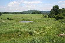
 Countryside in Fairfield | |
 Location in Franklin County and the state of Vermont. | |
| Coordinates: 44°48′52″N 72°55′35″W / 44.81444°N 72.92639°WCoordinates: 44°48′52″N 72°55′35″W / 44.81444°N 72.92639°W | |
| Country | United States |
| State | Vermont |
| County | Franklin |
| Communities |
Fairfield East Fairfield Fairfield Station Saint Rocks |
| Area | |
| • Total | 68.5 sq mi (177.4 km2) |
| • Land | 67.4 sq mi (174.6 km2) |
| • Water | 1.1 sq mi (2.9 km2) |
| Elevation | 486 ft (148 m) |
| Population (2010) | |
| • Total | 1,891 |
| • Density | 28/sq mi (10.8/km2) |
| Time zone | UTC-5 (Eastern (EST)) |
| • Summer (DST) | UTC-4 (EDT) |
| ZIP code | 05455 |
| Area code(s) | 802 |
| FIPS code | 50-25225[1] |
| GNIS feature ID | 1462093[2] |
| Website |
fairfieldvermont |
Fairfield is a town in Franklin County, Vermont, United States. The population was 1,891 at the 2010 census.[3] President Chester A. Arthur was born in Fairfield in 1829, and lived there for the first three years of his life. The Chester Alan Arthur State Historic Site is open seasonally.
Geography
Fairfield occupies central Franklin County, east of St. Albans. Vermont Route 36 crosses the town from east to west.
According to the United States Census Bureau, the town has a total area of 68.5 square miles (177.4 km2), of which 67.4 square miles (174.6 km2) is land and 1.1 square miles (2.9 km2), or 1.61%, is water. The town is drained by Black Creek, a north-flowing tributary of the Missisquoi River. Fairfield Pond is in the town's northwest corner. The town's rolling hills are used for growing hay, corn, and pasture for dairy farms, but also for growing of maple trees for maple syrup production.
Demographics
| Historical population | |||
|---|---|---|---|
| Census | Pop. | %± | |
| 1790 | 129 | — | |
| 1800 | 901 | 598.4% | |
| 1810 | 1,618 | 79.6% | |
| 1820 | 1,573 | −2.8% | |
| 1830 | 2,270 | 44.3% | |
| 1840 | 2,448 | 7.8% | |
| 1850 | 2,591 | 5.8% | |
| 1860 | 2,497 | −3.6% | |
| 1870 | 2,391 | −4.2% | |
| 1880 | 2,172 | −9.2% | |
| 1890 | 1,825 | −16.0% | |
| 1900 | 1,830 | 0.3% | |
| 1910 | 1,778 | −2.8% | |
| 1920 | 1,532 | −13.8% | |
| 1930 | 1,541 | 0.6% | |
| 1940 | 1,444 | −6.3% | |
| 1950 | 1,428 | −1.1% | |
| 1960 | 1,225 | −14.2% | |
| 1970 | 1,285 | 4.9% | |
| 1980 | 1,493 | 16.2% | |
| 1990 | 1,680 | 12.5% | |
| 2000 | 1,800 | 7.1% | |
| 2010 | 1,891 | 5.1% | |
| Est. 2014 | 1,911 | [4] | 1.1% |
| U.S. Decennial Census[5] | |||
As of the census[1] of 2000, there were 1,800 people, 620 households, and 486 families residing in the town. The population density was 26.6 people per square mile (10.3/km2). There were 768 housing units at an average density of 11.3 per square mile (4.4/km2). The racial makeup of the town was 97.00% White, 0.89% Native American, 0.11% Asian, 0.17% Pacific Islander, 0.28% from other races, and 1.56% from two or more races. Hispanic or Latino of any race were 1.28% of the population.
There were 620 households out of which 40.0% had children under the age of 18 living with them, 65.0% were married couples living together, 8.5% had a female householder with no husband present, and 21.6% were non-families. 16.0% of all households were made up of individuals and 4.2% had someone living alone who was 65 years of age or older. The average household size was 2.90 and the average family size was 3.23.
In the town, the population was spread out with 30.4% under the age of 18, 6.2% from 18 to 24, 32.2% from 25 to 44, 23.6% from 45 to 64, and 7.6% who were 65 years of age or older. The median age was 35 years. For every 100 females, there were 97.8 males. For every 100 females age 18 and over, there were 99.8 males.
The median income for a household in the town was $44,219, and the median income for a family was $48,542. Males had a median income of $31,756 versus $24,258 for females. The per capita income for the town was $17,307. About 5.9% of families and 9.3% of the population were below the poverty line, including 10.0% of those under age 18 and 7.5% of those age 65 or over.
Notable people
- Chester A. Arthur, 21st president of the United States
- Consuelo Northrop Bailey, first female lieutenant governor of any US state
- Bradley Barlow, US congressman
- Jeptha Bradley, Vermont Auditor of Accounts
- John Fitzpatrick, mayor of New Orleans
- Charles Shattuck Hill, editor
References
- 1 2 "American FactFinder". United States Census Bureau. Archived from the original on 2013-09-11. Retrieved 2008-01-31.
- ↑ "US Board on Geographic Names". United States Geological Survey. 2007-10-25. Retrieved 2008-01-31.
- ↑ "Geographic Identifiers: 2010 Demographic Profile Data (G001): Fairfield town, Franklin County, Vermont". U.S. Census Bureau, American Factfinder. Retrieved September 12, 2016.
- ↑ "Annual Estimates of the Resident Population for Incorporated Places: April 1, 2010 to July 1, 2014". Archived from the original on May 23, 2015. Retrieved June 4, 2015.
- ↑ "U.S. Decennial Census". United States Census Bureau. Archived from the original on May 12, 2015. Retrieved May 16, 2015.


External links
Municipalities and communities of Franklin County, Vermont, United States | ||
|---|---|---|
| City | 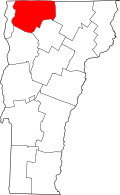 | |
| Towns | ||
| Villages | ||
| CDP | ||
| Unincorporated communities | ||