Montgomery Center, Vermont
| Montgomery Center, Vermont | |
|---|---|
| Village | |
 Montgomery Center | |
| Coordinates: 44°52′41″N 72°36′08″W / 44.87806°N 72.60222°WCoordinates: 44°52′41″N 72°36′08″W / 44.87806°N 72.60222°W | |
| Country | United States |
| State | Vermont |
| County | Franklin |
| Elevation | 591 ft (180 m) |
| Time zone | UTC-5 (Eastern (EST)) |
| • Summer (DST) | UTC-4 (EDT) |
| ZIP code | 05471 |
| Area code(s) | 802 |
| GNIS feature ID | 1458522[1] |
Montgomery Center is an unincorporated village in the town of Montgomery, Franklin County, Vermont, United States. The community is located at the intersection of Vermont Routes 58, 118, and 242, 10 miles (16 km) east-southeast of Enosburg Falls. Montgomery Center has a post office with ZIP code 05471.[2][3]
References
- ↑ "Montgomery Center". Geographic Names Information System. United States Geological Survey.
- ↑ United States Postal Service. "USPS - Look Up a ZIP Code". Retrieved April 30, 2017.
- ↑ "Postmaster Finder - Post Offices by ZIP Code". United States Postal Service. Retrieved April 30, 2017.
Municipalities and communities of Franklin County, Vermont, United States | ||
|---|---|---|
| City | 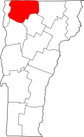 | |
| Towns | ||
| Villages | ||
| CDP | ||
| Unincorporated communities | ||
This article is issued from
Wikipedia.
The text is licensed under Creative Commons - Attribution - Sharealike.
Additional terms may apply for the media files.