Expressways of Singapore
| Expressways of Singapore (新加坡的快速公路) (Rangkaian Lebuhraya Singapura) | |
|---|---|
 Symbol of the Singaporean expressways | |
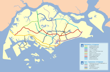 Map of Singaporean expressway network as in 2012 | |
| System information | |
| Maintained by Land Transport Authority (LTA) | |
| Length | 163 km (101 mi) |
| Formed | 1966 |
| Highway names | |
| Expressways | Expressway AAA (AAA) |
| System links | |
| Expressways of Singapore | |

The Expressways of Singapore are special roads that allow motorists to travel quickly from one urban area to another. All of them are dual carriageways with grade-separated access. They usually have three to four lanes in each direction, although there are two-lane carriageways at many expressway - expressway intersections and five-lane carriageways in some places. There are ten expressways, including the new Marina Coastal Expressway. Studies about the feasibility of additional expressways are ongoing.
Construction on the first expressway, the Pan Island Expressway, started in 1966. As of 2014, there are 163 kilometres (101 mi) of expressways in Singapore.[1]
The Singaporean expressway networks are connected with Malaysian expressway networks via Ayer Rajah Expressway (connects with the Second Link Expressway in Malaysia) and Bukit Timah Expressway (connects with the Johor Bahru Eastern Dispersal Link Expressway via Johor–Singapore Causeway).
History
| Date | Events | Remarks |
|---|---|---|
| 15 April 1962 | Construction of the Pan Island Expressway (PIE) begins. | |
| 8 May 1966 | First phase of the Pan Island Expressway (PIE) completed. Construction of the second phase of the PIE begins. | Whitley Road: Mount Pleasant Flyover - Thomson Flyover - Jalan Toa Payoh - Jalan Kolam Ayer - Paya Lebar Way |
| 14 December 1970 | Toa Payoh Flyover, Singapore's first flyover is opened to motorists. | Length: 1.2 kilometres |
| 23 January 1971 | Construction of the East Coast Parkway (ECP) begins with the land reclamation of East Coast. | |
| 12 December 1974 | First phase of the East Coast Parkway (ECP) completed. | Fort Road – Marine Parade Formerly called Bedok Highway |
| 15 July 1975 | Planning for the Sembawang Expressway begins from Ang Mo Kio Avenue 3 to Ang Mo Kio Avenue 1. | |
| 22 February 1976 | Second phase of the East Coast Parkway (ECP) completed. | Marine Parade – Bedok South Road Formerly called Bedok Highway |
| 30 September 1976 | Opening of the Pan Island Expressway (PIE) completed. | Adam Road - Jalan Anak Bukit |
| 1 January 1977 | Planning for the Sembawang Expressway was extended to Yio Chu Kang Road. | |
| 19 January 1980 | Opening of the Pan Island Expressway (PIE) completed. | Whitley Road - Adam Road |
| 22 January 1980 | Third phase of the East Coast Parkway (ECP) completed. | Bedok South Road – Changi Airport It was renamed to East Coast Parkway |
| 15 March 1980 | Third phase of the Pan Island Expressway (PIE) completed. | Jalan Eunos - Changi Airport |
| 25 April 1980 | Opening of the Pan Island Expressway (PIE) completed. | Hong Kah Drive - Jalan Boon Lay |
| 25 October 1980 | Opening of the Pan Island Expressway (PIE) completed. | Jalan Eunos - Bedok North Road |
| 10 January 1981 | Opening of the Pan Island Expressway (PIE) completed. | Bedok North Road - East Coast Parkway |
| 29 January 1981 | Opening of the Pan Island Expressway (PIE) completed. | Hong Kah Drive - Jalan Anak Bukit |
| 18 April 1981 | Opening of the Benjamin Sheares Bridge on the East Coast Parkway (ECP) and the completion of the ECP phase 4 from Fort Road to Keppel Road. | ECP Length: 20 kilometres ECP phase 4: Fort Road - Keppel Road |
| 11 July 1981 | Construction of the Sembawang Expressway (renamed to Central Expressway) begins. | |
| 20 December 1981 | Fourth phase of the Pan Island Expressway (PIE) completed. | Jalan Anak Bukit - Jurong Road |
| 5 March 1983 | Construction of the Ayer Rajah Expressway (AYE) begins. | |
| 31 March 1983 | Opening of the Central Expressway (CTE) Phase 1. | Ang Mo Kio Avenue 1 - PIE |
| 23 September 1983 | Construction of the Bukit Timah Expressway (BKE) begins. | |
| 18 May 1985 | Opening of the Central Expressway (CTE) Phase 1. | PIE - Thomson Road |
| 22 January 1986 | Opening of the Bukit Timah Expressway (BKE). | Length: 10 kilometres |
| 1 July 1986 | Construction of the Central Expressway (CTE) phase 2 including Kampong Java Tunnel and Chin Swee Tunnel. | Cavenagh Road was closed to make way for the construction of Central Expressway. |
| 30 September 1987 | Opening of the Tampines Expressway (TPE) phase 1. | PIE - Elias Road |
| 24 December 1987 | Construction of the Tampines Expressway (TPE) phase 2. | Elias Road - Lorong Halus |
| 24 September 1988 | Construction of the Central Expressway (CTE) phase 2 from Ayer Rajah Expressway to Outram Road | |
| 5 November 1988 | Opening of the Ayer Rajah Expressway (AYE). | Keppel Viaduct - Jurong Town Hall Road |
| 15 April 1989 | Opening of the Tampines Expressway (TPE) phase 1. | Lentor Avenue - Upper Thomson Road |
| 2 June 1989 | Opening of the Tampines Expressway (TPE) phase 1. | Elias Road - Old Tampines Road |
| 17 June 1989 | Opening of the Central Expressway (CTE) phase 1 | Yio Chu Kang Road – Ang Mo Kio Avenue 1 Opened by: Mr Heng Chiang Meng |
| 24 March 1990 | Opening of the Seletar Expressway (SLE) phase 1. | Yio Chu Kang Road – Lentor Avenue |
| 11 May 1991 | The completion of the Central Expressway (CTE) phase 2 including Kampong Java Tunnel and Chin Swee Tunnel | Length: 15.8 kilometres |
| 21 September 1991 | Opening of the Central Expressway (CTE) phase 2 including Kampong Java Tunnel and Chin Swee Tunnel | Length: 15.8 kilometres |
| 31 October 1991 | Construction of the Kranji Expressway (KJE) begins. | |
| 5 December 1993 | Opening of the Pan Island Expressway (PIE). | Jurong Road - Upper Jurong Road |
| 20 February 1994 | Opening of the Kranji Expressway (KJE). | Length: 8 kilometres |
| 29 November 1994 | Construction of the Ayer Rajah Expressway (AYE) phase 2 begins. | Jurong Town Hall Road - Corporation Road |
| 5 November 1995 | Opening of the Seletar Expressway (SLE) phase 2. | Bukit Timah Expressway – Woodlands Avenue 2 |
| 3 September 1996 | Opening of the Tampines Expressway (TPE) phase 2. | Old Tampines Road - SLE |
| 2 January 1998 | Opening of the Ayer Rajah Expressway (AYE) phase 2. | Jurong Town Hall Road - Tuas Second Link |
| 22 February 1998 | Opening of the Seletar Expressway (SLE) phase 2. | Length: 10.8 kilometres Woodlands Avenue 2 - Upper Thomson Road Opened by: Mr John Chen Seow Phun, Minister of State for Communications |
| 22 August 1998 | Opening of the Tampines Expressway viaduct connecting PIE and TPE. | |
| September 1998 | The Electronic Road Pricing (ERP) systems is implemented on all expressways. | |
| 2001 | Construction of the Kallang-Paya Lebar Expressway begins. | |
| 2004 | The SOS telephones were removed on all expressways except for tunnels. | |
| 23 June 2007 | Opening of the Tampines Service Road, currently part of the Kallang-Paya Lebar Expressway (KPE) | |
| 28 October 2007 | Opening of the Kallang–Paya Lebar Expressway (KPE), the longest subterranean road tunnel in Southeast Asia. | ECP - PIE |
| March 2008 | Construction of the Marina Coastal Expressway (MCE) begins. | |
| 20 September 2008 | Official opening of the Kallang-Paya Lebar Expressway (KPE). | Prime Minister Lee Hsien Loong PIE - TPE |
| 29 December 2013 | Opening of the Marina Coastal Expressway (MCE), Singapore's first undersea expressway. | Length: 5 kilometres The East Coast Parkway was shortened to Sheares Avenue. |
Expansion
The latest expressway completed is the Marina Coastal Expressway which runs for 5 km, 3.5 km of which are underground. Construction started in 2008 and ended in late 2013. It was opened to the public on 29 December 2013. Prior to construction of the Marina Coastal Expressway, the Kallang–Paya Lebar Expressway which runs for 12 km, 9 km of which are 10 m underground, was started in 2001 and a 3 km section linking the Pan Island Expressway and East Coast Parkway was opened in late 2007. The Kallang–Paya Lebar Expressway was completed on 20 September 2008.
On 27 July 2007, the Land Transport Authority announced that approval had been given for the construction of a new 5 km long Marina Coastal Expressway (MCE) at a cost of $2.5 billion.[2] The expressway, which includes Singapore's first undersea tunnel, links the East Coast Parkway and Kallang-Paya Lebar Expressway to Marina South and Ayer Rajah Expressway and opened to traffic 29 December 2013.[3][4]
Construction of the 11th expressway, the North–South Corridor, originally conceptualised as the North-South Expressway was announced on 30 January 2008. The new 21.5-kilometre expressway will cost about $7 to $8 billion when fully completed by 2023 and will connect the East Coast Parkway with the northern parts of Singapore. In 2016, the Land Transport Authority announced that the North–South Corridor will be Singapore’s first integrated transport corridor featuring continuous bus lanes and cycling trunk routes, rather than a normal expressway when originally conceptualised.
Features
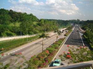
Like all other global controlled-access expressway network, there are no traffic lights on the expressways. At an interchange with another road, an expressway is connected to it via slip roads. This allows traffic to change routes without having to stop or slow down. Due to the need to conserve space in land-scarce Singapore, there are no cloverleaf interchanges on the entire island. Instead, traffic efficiency and land space are maximized by having traffic lights on terrestrial roads, as well as the usage of interchanges such as stack interchanges. The most common forms of highway-road or highway-highway intersections are single-point urban, diamond, and trumpet interchanges. Newer expressways such as the Kallang-Paya Lebar Expressway and the future North South Corridor uses on-ramps and off-ramps to conserve space even further and minimize disruption to the road system, through the construction of viaducts and tunnels.
The road surface is asphalt, unlike normal roads which may have concrete surfaces. The lanes are separated with white dashed lines, while unbroken white lines are used to mark the edges of the median and shoulder. The shoulder is reserved for stops due to breakdowns and emergencies, and motorists are prohibited by law from travelling on it. Lanes are numbered from right to left, with lane 1 being the closest to the median. Crash barriers, cat's eyes and rumble strips are also used to ensure road safety.
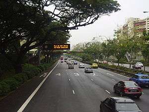
There are signs marking the start and end of an expressway at its entry and exit points respectively. The expressways are also assigned route codes consisting three letters that form their respective initials, making the Singaporean expressway network as the only highway system with route coding system. The Expressway Monitoring and Advisory System is used on all the expressways—cameras are used for live monitoring of expressway conditions, and LED signboards display information messages, such as warnings of any disruptions to the normal flow of traffic, as well as estimated travel times. The longest expressway, the Pan Island Expressway, is only 41 km (25 mi) long and therefore has no rest areas.
Singaporean expressways are the only highway network in Singapore with their own route codes. They are assigned with three-letter codes named after their respective initials where the last letter is always E; for example, PIE for the Pan Island Expressway. The only exception is the East Coast Parkway (ECP) whose the last letter is other than E.
Safety
The default speed limit and National Speed Limits on Singapore expressways is 90 km/h (56 mph), but in certain areas a lower speed limit such as 80 km/h (50 mph) or 70 km/h (43 mph) is applied, especially in large urban areas, tunnels, heavy traffic and crosswinds. Speed traps are also deployed by the Singapore police at many places along the expressways and are deployed from 7am to 12am.
Certain types of transport, such as pedestrians, bicycles, and learner drivers, are not allowed.
Semi-expressways
In Singapore, there are five semi-expressways: Bukit Timah Road, Jurong Island Highway, Nicoll Highway, the Outer Ring Road System (ORRS) and West Coast Highway. These semi-expressways are scaled down versions of expressways. Semi-expressways do not have a uniform speed limit through its entire length, and some sections still feature traffic light controlled junctions, such as the eastern section of the ORRS and the controlled roundabout along the West Coast Highway. Still, just like expressways, semi-expressways allow motorists to travel quickly from one urban area to another with the use of viaducts, flyovers and underpasses.
List of Expressways
| Rank Number | Expressway Name | Abbreviation | Opened | Length | Exit Terminus | Remarks |
|---|---|---|---|---|---|---|
| 1st | Pan Island Expressway | PIE | 1966 | 42.8 km | Changi Airport, ECP Tuas, AYE |
Longest and Oldest Expressway in Singapore. |
| 2nd | Ayer Rajah Expressway | AYE | 1988 | 26.5 km | Keppel Tuas Checkpoint, Tuas Second Link |
Disconnected from ECP from 29 December 2013. It is connected to MCE since. |
| 3rd | North–South Corridor | NSC | 2023 | 21.5 km | Admiralty Road West ECP, Republic Avenue and Nicoll Highway |
Construction starting in 2017 after redesign. Completion by 2023. The NSC will be Singapore’s first integrated transport corridor featuring continuous bus lanes and cycling trunk routes. |
| 4th | East Coast Parkway | ECP | 1974 | 20 km | Changi Airport, PIE Marina Boulevard |
No longer connected with the AYE from 29 December 2013 with the opening of MCE. |
| 5th | Central Expressway | CTE | 1989 | 15.8 km | SLE AYE |
This Expressway has two tunnels, Kampong Java Tunnel and Chin Swee Tunnel. Directly connected to SLE |
| 6th | Tampines Expressway | TPE | 1989 | 14 km | SLE, CTE PIE Upper Changi Road East |
|
| 7th | Kallang-Paya Lebar Expressway | KPE | 2008 | 12 km | MCE, ECP TPE |
The expressway has the longest road tunnel in Singapore. |
| 8th | Seletar Expressway | SLE | 1990 | 10.8 km | BKE, Turf Club Ave CTE |
Directly connected to CTE. |
| 9th | Bukit Timah Expressway | BKE | 1986 | 10 km | PIE Woodlands Checkpoint, Johor–Singapore Causeway |
|
| 10th | Kranji Expressway | KJE | 1994 | 8 km | BKE PIE |
|
| 11th | Marina Coastal Expressway | MCE | 2013 | 5 km | AYE Tanjong Rhu, KPE |
Singapore's First undersea expressway. |
See also
References
- ↑ "Expressways in Singapore: Did you know?". The Highway. Automobile Association of Singapore. July 2001. Archived from the original on 10 March 2006. Retrieved 5 April 2006.
- ↑ "Government Approves the Construction of MCE" (Press release). Land Transport Authority. 27 July 2007. Archived from the original on 18 August 2007.
- ↑ "Marina expressway to be ready by year-end". The Straits Times. Retrieved 31 May 2013.
- ↑ "Singapore's first undersea road—Marina Coastal Expressway—set to open on Dec 29". The Straits Times. 13 November 2013.
Motorways in Asia | |
|---|---|
| Sovereign states | |
| States with limited recognition | |
| Dependencies and other territories | |
| |