Esopus, New York
| Esopus, New York | |
|---|---|
| Town | |
 Esopus Town Hall | |
 Location in Ulster County and the state of New York. | |
| Coordinates: 41°51′21″N 73°59′31″W / 41.85583°N 73.99194°W | |
| Country | United States |
| State | New York |
| County | Ulster |
| Area[1] | |
| • Total | 41.94 sq mi (108.62 km2) |
| • Land | 37.31 sq mi (96.64 km2) |
| • Water | 4.63 sq mi (11.99 km2) |
| Elevation | 650 ft (198 m) |
| Population (2010) | |
| • Total | 9,041 |
| • Estimate (2016)[2] | 8,839 |
| • Density | 236.89/sq mi (91.47/km2) |
| Time zone | UTC-5 (Eastern (EST)) |
| • Summer (DST) | UTC-4 (EDT) |
| ZIP code | 12429 |
| Area code(s) | 845 |
| FIPS code | 36-24691 |
| GNIS feature ID | 0978944 |
Esopus is a town in Ulster County, New York, United States. The population was 9,041 at the 2010 census. The town was named after the local Indian tribe and means "high banks" in English. They were one of the Lenape (Delaware) bands, belonging to a people who ranged from western Connecticut through lower New York, western Long Island, and parts of New Jersey and Pennsylvania along the Delaware River.
The Town of Esopus is on the west bank of the Hudson River south of the City of Kingston. The town center is in Port Ewen. US Route 9W passes along the east side of the town.
History
This area was a notable trading site between the Dutch colonists and the native Esopus tribe in the 17th century. The Town of Esopus was founded by Americans in 1811 from territory taken from Kingston, New York, which also was called "Esopus" at one time.
The townsite was inhabited during the American Revolution, and a Colonial Prison was established there in the Fall of 1777 to house overcrowding of a prison ship anchored offshore. The British Army attacked this settlement in the same year and burned it to the ground.[3]
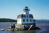
The Cumming-Parker House, Esopus Meadows Lighthouse, Col. Oliver Hazard Payne Estate, Poppletown Farmhouse, and Reformed Protestant Dutch Church of Klyne Esopus are listed on the National Register of Historic Places.[4]
In the early 19th century, Esopus was a popular summer residence for wealthy American families such as the Astors, Durkees, Paynes, Rockefellers, Smiths, Tiffanys and Whitneys, who built architecturally significant mansions and hunting lodges on the west bank of the Hudson River, across from the Vanderbilt and Roosevelt estates on the east bank. By 1864, the Hudson Valley had lost some luster among the very rich, who had begun to favor Newport, Rhode Island.
Historical figures and celebrated people who have lived in Esopus include naturalist John Burroughs; financier Harry Payne Bingham; abolitionist Sojourner Truth; 19th-century U.S. politician George W. Pratt; Standard Oil treasurer Colonel Oliver Hazard Payne; business leader and president of Avco Corporation Raymond Rich; the Smith Brothers, who invented the first cough drops in America; Saint Frances Xavier Cabrini (patron saint of immigrants); Major Gen. Daniel Butterfield, who founded the American Express Company and wrote "Taps" in 1862; Eugene R. Durkee, who made a fortune in spices and salad dressings and whose West Park summer mansion became part of the Christian Brothers monastery; John Jacob Astor III; boxing champion Floyd Patterson; who attended Wiltwyck School for Boys in West Park; and Alton Brooks Parker, a lawyer and judge who ran for U.S president as the 1904 Democratic Party nominee, losing to incumbent Theodore Roosevelt.
In the early part of the 21st century, Esopus became known as a haven for artists and performers, including Academy Award and Tony Award-winning actress Frances McDormand, singer and Broadway actress Kelli O'Hara, actor Sebastian Roche, director Joel Coen, choreographer/director Joe Langworth, actress Blair Ross, Emmy Award-winning actor Peter Dinklage, actress Connie Ray, and musician Greg Naughton.
United Nations
In 1946, Espous was one of several towns under consideration for the United Nations headquarters. Esopus was not alone: no less than 248 towns in New York State were interested, as well as cities in other parts of America and in nearly every European country. On January 9, 1946, a photo appeared in the Kingston Daily Freeman, with a caption reading, “The local UNO Committee mapping a tentative itinerary for the Sub-Committee of the United Nations Organization (UNO) was impressed with the view shown above from Camp Chi-Wan-Do on the River road between Port Ewen and Ulster Park.” Many local property owners organized to oppose the proposed UN headquarters, however, fearing eminent domain. Ultimately, a donation of more than eight million dollars by John D. Rockefeller, Jr. for 16 acres of land in Manhattan provided the UN with its current headquarters in 1948.[5]
Geography
According to the United States Census Bureau, the town has a total area of 41.9 square miles (109 km2), of which, 37.2 square miles (96 km2) of it is land and 4.6 square miles (12 km2) of it (11.08%) is water.
The east town line, marked by the Hudson River, is the border of Dutchess County. The Rondout Creek marks the north town line, while the Wallkill River defines the western border.
The lowest point in the town is the shore of the Hudson River, which is at sea level. The highest point is the summit of Hussey Hill, at 906 feet (276 m).[6] Hussey Hill is part of the Marlboro Mountains, which run roughly north to south through the central and eastern sections of Esopus.
Esopus also has three lakes; Esopus Lake and Mirror Lake, which are in Ulster Park, and Louisa Pond, which is located to the west of the village of Esopus. Louisa Pond is located in Shaupeneak Ridge Cooperative Recreation Area.
Demographics
| Historical population | |||
|---|---|---|---|
| Census | Pop. | %± | |
| 1820 | 1,513 | — | |
| 1830 | 1,770 | 17.0% | |
| 1840 | 1,939 | 9.5% | |
| 1850 | 2,900 | 49.6% | |
| 1860 | 4,734 | 63.2% | |
| 1870 | 4,557 | −3.7% | |
| 1880 | 4,736 | 3.9% | |
| 1890 | 4,659 | −1.6% | |
| 1900 | 4,907 | 5.3% | |
| 1910 | 4,732 | −3.6% | |
| 1920 | 3,913 | −17.3% | |
| 1930 | 4,167 | 6.5% | |
| 1940 | 4,220 | 1.3% | |
| 1950 | 4,738 | 12.3% | |
| 1960 | 6,597 | 39.2% | |
| 1970 | 6,974 | 5.7% | |
| 1980 | 7,605 | 9.0% | |
| 1990 | 8,860 | 16.5% | |
| 2000 | 9,331 | 5.3% | |
| 2010 | 9,041 | −3.1% | |
| Est. 2016 | 8,839 | [2] | −2.2% |
| U.S. Decennial Census[7] | |||
As of the 2000 census[8] there were 9,331 people, 3,439 households and 2,235 families residing in the town. The population density was 250.5 people per square mile (96.7/km²). There were 3,724 housing units at an average density of 100.0 per square mile (38.6/km²). The racial makeup of the town was 94.57% White; 2.18% African American; 0.24% Native American; 0.94% Asian; 0.49% from other races; and 1.59% from two or more races. Hispanic or Latino of any race were 1.91% of the population.
There were 3,439 households out of which 29.5% had children under the age of 18 living with them; 51.7% were married couples living together; 8.8% had a female householder with no husband present; and 35.0% were non-families. 27.6% of all households were made up of individuals and 8.6% had someone living alone who was 65 years of age or older. The average household size was 2.45 and the average family size was 3.01.
The population in town was spread out with 25.4% under the age of 18; 6.9% from 18 to 24; 29.3% from 25 to 44; 25.9% from 45 to 64; and 12.6% who were 65 years of age or older. The median age was 39 years. For every 100 females, there were 93.7 males. For every 100 females age 18 and over, there were 91.0 males.
The median income for a household in the town was $46,915, and the median income for a family was $55,442. Males had a median income of $38,016 versus $31,010 for females. The per capita income for the town was $21,174.
Emergency Services
Fire
Fire protection in the town is split into five different fire districts, that are listed below.
- Connelly - The district provides coverage to the Connelly hamlet region of the town
- Esopus - The district provides coverage for the south/east part of the town. The north boundary is in the area of Cross St/9w
- Rifton - The district provides coverage for the south/west part of the town. The north boundary is in the area of Coffee Systems on Route 213
- St Remy - This district provides coverage for the north/west part of the town. The south boundary is in the area of Coffee Systems on Route 213
- Port Ewen - The district provides coverage for the north/east part of the town.. The south boundary is in the area of Cross St/9w
Medical
Emergency Medical Services is provided by the Town of Esopus Ambulance Services and is staff by volunteers.[9]
.
Communities and locations in Esopus
- Connelly – A hamlet in the northeast part of the town and suburb of Kingston. It is on the south bank of Rondout Creek.
- Dashville – A hamlet south of Rifton.
- Esopus – A hamlet by the Hudson River and located on Route 9W; features business such as Black Bear Trading Post and The Country Store.
- New Salem – A hamlet at the north town line by Rondout Creek.
- Port Ewen – A hamlet in the northeast part of the town and suburb of Kingston.
- Rifton – A hamlet in the western part of the town on Route 213.
- St. Remy – A hamlet south of New Salem.
- Sleightsburgh – A hamlet at the northeast corner of the town and suburb of Kingston. The community is at the mouth of Rondout Creek.
- Ulster Park – A hamlet north of Esopus hamlet on Route 9W.
- Union Center – A hamlet west of Ulster Park.
- West Park – A hamlet south of Esopus hamlet on Route 9W.
See also
References
- ↑ "2016 U.S. Gazetteer Files". United States Census Bureau. Retrieved Jul 5, 2017.
- 1 2 "Population and Housing Unit Estimates". Retrieved June 9, 2017.
- ↑ Hurd, Anner. "Land Petitions of Upper Canada, 1763-1865". RG 1 L3, C-2046-00745. Gov't of Canada. Retrieved 10 July 2018.
- ↑ National Park Service (2010-07-09). "National Register Information System". National Register of Historic Places. National Park Service.
- ↑ About Town: What Might Have Been
- ↑ "Hussey Hill Summit - New York Mountain Peak Information". Retrieved 2011-08-14.
- ↑ "Census of Population and Housing". Census.gov. Archived from the original on May 12, 2015. Retrieved June 4, 2015.
- ↑ "American FactFinder". United States Census Bureau. Archived from the original on 2013-09-11. Retrieved 2008-01-31.
- ↑ "Town of Esopus Volunteer Ambulance Squad : Squad History and Information". esopusems.com. Retrieved 2018-10-03.
External links
- Town of Esopus, New York
- Town of Esopus Library
- Connelly Fire Department
- Rifton Fire Department
- Port Ewen Volunteer Fire Department
- Esopus Fire Department
- St Remy Fire Department
- Town of Esopus EMS
Municipalities and communities of Ulster County, New York, United States | ||
|---|---|---|
| City | 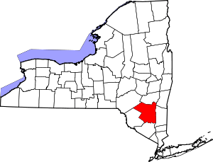 | |
| Towns | ||
| Villages | ||
| CDPs |
| |
| Other hamlets |
| |
| Footnotes | ‡This populated place also has portions in an adjacent county or counties | |
Coordinates: 41°49′40″N 73°57′54″W / 41.82778°N 73.96500°W