Emi Koussi
| Emi Koussi | |
|---|---|
 Emi Koussi seen from space | |
| Highest point | |
| Elevation | 3,445 m (11,302 ft) [1] |
| Prominence |
2,934 m (9,626 ft) [1] Ranked 103rd |
| Isolation | 2,001 kilometres (1,243 mi) |
| Listing |
Country high point Ultra |
| Coordinates | 19°47′37″N 18°33′7″E / 19.79361°N 18.55194°ECoordinates: 19°47′37″N 18°33′7″E / 19.79361°N 18.55194°E |
| Geography | |
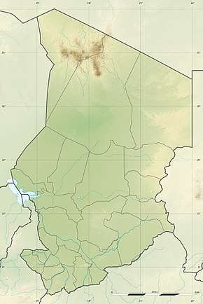 Emi Koussi Location in Chad | |
| Location | Chad |
| Parent range | Tibesti Mountains |
| Geology | |
| Age of rock | Holocene |
| Mountain type | Pyroclastic shield |
| Last eruption | unknown |
| Climbing | |
| Easiest route | Hike |
Emi Koussi (also known as Emi Koussou[2]) is a high pyroclastic shield[3] volcano that lies at the southeast end of the Tibesti Mountains in the central Sahara of the northern Borkou Region of northern Chad. It is the highest mountain of the Sahara. The volcano is one of several in the Tibesti Mountains, and reaches 3,445 metres (11,302 ft) in elevation, rising 3 km (1.9 mi) above the surrounding sandstone plains. The volcano is 60–70 kilometres (37–43 mi) wide.
Two nested calderas cap the volcano, the outer one being about 15 by 11 kilometres (9.3 mi × 6.8 mi) in size. Within it on the southeast side is a smaller caldera known as Era Kohor, about 2 kilometres (1.2 mi) wide and 350 m deep. Numerous lava domes, cinder cones, maars, and lava flows are found both within the calderas and along the outer flanks of the shield. Era Kohor contains trona deposits, and Emi Koussi has been studied as an analogue of the Martian volcano Elysium Mons. Emi Koussi was active over one million years ago, but some eruptions may be more recent, and there is ongoing fumarolic and hot spring activity.
Geography and geomorphology
Emi Koussi lies in Chad, Africa, and is part of the Tibesti Mountains.[4] Emi Koussi is the highest of these Tibesti mountains[5] and thus of the Sahara;[6] many mountains of the Tibesti exceed 2,000 metres (6,600 ft) height.[5] These mountains are formed by a group of volcanoes that grew on top of a large dome of Earth's surface.[7] Volcanism there is poorly studied, as the region is remote and access difficult for political reasons.[8] According to historical reports, the Tibu people lived in its summit caldera of Emi Koussi[9] and in artificial caves in the mountain.[10] In the Tedaga language, "Emi" means "mountains", "massif".[6]
Emi Koussi rises to a height of 3,445 metres (11,302 ft)[1] on the southern side of the volcano,[11][12] towering 3 kilometres (1.9 mi) above the surrounding terrain.[13] It is considered by some astronauts to be the most recognizable landmark on Earth, as seen from orbit.[13] Supposedly the entire Tibesti can be seen from the northern summits.[14]
It is a shield volcano with a diameter of 60–70 kilometres (37–43 mi)[13] and an estimated volume of 2,500 cubic kilometres (600 cu mi).[15] The summit of Emi Koussi is formed by two overlapping calderas, which together form a[16] 15 by 11 kilometres (9.3 mi × 6.8 mi) wide[13] ellipse-shaped caldera that extends from northwest to southeast.[16] The northern caldera formed first, then the southern caldera which is about 50 metres (160 ft) deeper below the northern one. 400–300 metres (1,310–980 ft) high scarps form the inner margin of the southern caldera,[17] with the floor at an elevation of 2,970 metres (9,740 ft).[18] Before the formation of the calderas, the volcano may have reached a height of 4,000 metres (13,000 ft). Emi Koussi has been compared to a Martian volcano, Elysium Mons.[5][19] The caldera rim is cut by one outlet, the Porte de Modiounga.[20]
Nested within this combined caldera is the Era Kohor caldera,[16] which is 300 metres (980 ft) deep and 2 kilometres (1.2 mi) wide, having the appearance of a giant hole.[17] This caldera is also known as Natron Hole[14] or Trou au Natron.[11] Trachytic lava flows are exposed in its walls,[17] and sodium carbonate has been deposited on its floor,[21] which lies at an elevation of 2,670 metres (8,760 ft)[18] and contains a salt lake.[10] The floor of Era Kohor is thus deep white.[20] Three maars and several scoria cones are also nested within the combined caldera,[17] along with lava domes and lava flows.[3] Debris from explosive eruptions fills the calderas.[22]
The Kohor pumices and two sets of ignimbrites cover the flanks of Emi Koussi,[16] which steepen as they approach the summit.[19] Scoria cones on the slopes are accompanied by lava flows.[16] On the upper sectors of the volcano, lavas are crisscrossed by cracks, which are known as "lappiaz".[23] Sandstone crops out on the terrain surrounding the volcano.[16] North of Emi Koussi lie other volcanoes, such as Tarso Ahon and Tarso Emi Chi,[24] the former of which is connected to Emi Koussi by a narrow ridge.[11]
Geology
Tectonic activity appears to have occurred in the Tibesti already between the Carboniferous and the Cretaceous.[5] During the earliest stage of volcanism on Tibesti, alkali basalts formed large plateaus. Later, the central volcanoes developed on top of these plateaus.[13] Volcanism in Tibesti has been explained with a mantle plume, as has been proposed for other African volcanoes,[25] although recently far-field tectonic effects of the collision between African and Europe have also been advanced as an explanation.[26]
The oldest rocks below the Tibesti are Precambrian diorites, granites and schists,[24] which are probably of Neoproterozoic age and are differentiated into two units.[26] The volcanic rocks rest on an uplifted basement formed by Cretaceous[5] and Paleozoic sandstone.[13] The latter crop out at the southwestern foot of Emi Koussi, while volcanic rocks dominate north of the volcano and the Tibesti massif is prevalent east and southeast of Emi Koussi.[24] Older volcanic rocks are exposed in valleys.[27]
Emi Koussi has erupted phonolite, trachyandesite and trachyte,[13] as well as mafic rocks like basanite and tephrite. The erupted rocks define two alkaline suites. Phenocryst chemistry and content varies between the various rocks; among the minerals are alkali feldspar, amphibole, biotite, clinopyroxene, olivine, oxides and plagioclase. Alkali feldspar, apatite, clinopyroxene, olivine, magnetite, mica, nepheline, oxides, plagioclase, quartz, sodalite, titanite and zircon also form the groundmass of or microliths in erupted rocks.[28] Magma genesis mainly involved fractional crystallization processes.[25] Rocks from Emi Koussi were used as raw material by Neolithic societies of the region.[29]
During the early Holocene,[30] Era Kohor was filled with a deep, circular lake.[31] Diatom beds have been found 125 metres (410 ft) above the floor of Era Kohor[32] and in depressions without outlet elsewhere in the caldera,[33] they reach thicknesses of 4–5 metres (13–16 ft).[31] Farther down on the mountain, gullies start appearing at 2,800 metres (9,200 ft) elevation and become deep gorges by 2,000–2,500 metres (6,600–8,200 ft) elevation.[15] Elleboe wadi originates on Emi Koussi,[34] and several streams on the western flank join into the Enneri Miski which drains southwards and disappears south of the mountains.[35] Small pools of water are found around Emi Koussi.[36]
Eruptive history
Emi Koussi erupted between 2.4 and 1.3 million years ago,[37] it is considered to be of Pliocene-Quaternary age.[38] The volcano was constructed mainly during the Miocene[15][39] within about one million years.[40] Radiometric dating has yielded ages of 2.42 ± 0.03 million years ago to 2.33 ± 0.09 million years ago for the oldest Emi Koussi stage. The third stage has yielded ages of 1.4 ± 0.3 to 1.32 ± 0.2 million years ago;[13][41] formerly Era Kohor was considered to be a Holocene centre.[21]
During the first stage, Emi Koussi erupted trachytes and trachyandesites in the form of ignimbrites and basaltic lapilli. This was followed in the second stage by trachytic, green or grey ignimbrites, trachytic and phonolitic lava domes and additional basaltic lava flows.[13] The second stage ignimbrites can be found within the northern caldera and on the southern flank of the volcano.[17] The third stage was dominantly phonolitic, with breccia, tuffs and ignimbrites including the Kohor ignimbrite.[13] The various ignimbrites contain fiamme and often look like lava flows.[42] Each stage was accompanied by the formation of a caldera,[17] and basaltic volcanism continued through all three stages.[13] Phreatic explosions associated with Era Kohor have deposited large blocks within the summit caldera,[17] including beautifully coloured syenite blocks.[43]
Quaternary volcanism gave rise to the cones on the slopes of Emi Koussi,[16] and the three maars are the most recent vents in the combined caldera,[17] while long lava flows have been interpreted to be the youngest volcanism at Emi Koussi.[44] The most recent volcanic vents show little erosion.[43] Early in the Pleistocene, erosion took place on the flanks of Emi Koussi,[5] and trona was deposited in Era Kohor until recent times.[45][46]
On the southern foot of the volcano, fumaroles are active[5] such as at Yi Yerra at 850 metres (2,790 ft) elevation on the southern flanks.[22] At Yi Yerra, hot springs produce water with temperatures of 37 °C (99 °F).[47] Emi Koussi is considered to be a Holocene volcano,[45] lava flows have buried Holocene diatoms beds in its caldera;[10] dates of 14,790 ± 400 - 12,400 ± 400 years before present have been obtained by radiocarbon dating on diatom beds which have been penetrated or buried by lava flows.[48]
Climate and vegetation
The Tibesti mountains feature a desert mountain climate. There are no weather stations close to Emi Koussi and the stations at lower elevations likely underestimate precipitation at higher elevations,[35] but based on cloud cover data, a yearly precipitation of 80–120 millimetres (3.1–4.7 in) has been estimated for Emi Koussi;[49] in the past it was wetter than this.[12] The climate reflects both northerly and southerly influences and is distinct from that of the surrounding deserts.[48] There is no evidence of nivation forms on Emi Koussi[50] and the identification of periglacial landforms is questionable,[48] although periglacial activity likely occurred in the Pleistocene and may continue to the present-day.[47] Even during the Pleistocene, no part of the mountain had sub-freezing temperatures through the entire year.[51]
A number of diatom species have been identified in sediments left by the Era Kohor lake, including Cocconeis placentula, Cyclotella cyclopuncta, Cyclotella ocellata, Cymbella cistula, Cymbella leptoceros, Cymbella muelleri, Epithemia adnata, Fragilaria construens, Fragilaria pinnata, Gomphonema affine, Gomphonema parvulum, Navicula oblonga and Rhopalodia gibba.[52] The diatom fauna appears to be unusual in comparison to other Saharan paleolakes, probably owing to the high elevation of the Emi Koussi lake.[53] Cattail and water milfoil grew around the lake.[32]
Generally, in the Tibesti vegetation occurs in five different belts depending on elevation.[54] On Emi Koussi, Erica arborea is found to elevations of 2,900 metres (9,500 ft),[55] in the past it was probably more widespread.[56] The summit region features montane vegetation,[57] including Artemisia-Ephedra steppes[58] which cover large parts of the caldera floor[43] and may have been used as pastures.[20] The lava flows high on the mountain have characteristic environmental traits which allow the development of a particular vegetation.[59][23] This vegetation encompasses Dichrocephala, Eragrostis, Erodium, Helichrysum as well as ferns, liverworts and mosses.[58] Oldenlandia and Selaginella species grow at fumaroles.[60]
The wood rush Luzula tibestica is endemic on Emi Koussi.[57] The fern Asplenium quezelii was discovered on Emi Koussi and at first thought to be endemic there[61] before it was found to be identical to Asplenium daghestanicum, a species also previously considered to be endemic to Dagestan, over 3,800 kilometres (2,400 mi) away from Emi Koussi.[62]
Gallery
 Calderas of Emi Koussi
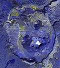 Emi Koussi caldera, ASTER
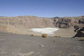 Emi Koussi inner crater
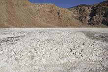 Natron in the inner caldera of Emi Koussi
See also
References
- 1 2 3 "Africa Ultra-Prominences". Peaklist.org. Retrieved 10 February 2013.
- ↑ Hellmich 1972, p. 10.
- 1 2 "Emi Koussi". Global Volcanism Program. Smithsonian Institution. Retrieved 3 November 2013.
- ↑ Gourgaud & Vincent 2004, p. 261.
- 1 2 3 4 5 6 7 Malin 1977, p. 908.
- 1 2 Pachur & Altmann 2006, p. 88.
- ↑ Gourgaud & Vincent 2004, p. 262.
- ↑ Permenter & Oppenheimer 2007, p. 609.
- ↑ Peel, R. F. (1942). "The Tibu Peoples and the Libyan Desert". The Geographical Journal. 100 (2): 75. doi:10.2307/1789494. JSTOR 1789494.
- 1 2 3 Pachur & Altmann 2006, p. 103.
- 1 2 3 Gèze et al. 1959, p. 137.
- 1 2 Messerli & Winiger 1992, p. 327.
- 1 2 3 4 5 6 7 8 9 10 11 Gourgaud & Vincent 2004, p. 264.
- 1 2 Tilho 1920, p. 172.
- 1 2 3 Hellmich 1972, p. 21.
- 1 2 3 4 5 6 7 Gourgaud & Vincent 2004, p. 263.
- 1 2 3 4 5 6 7 8 Gourgaud & Vincent 2004, p. 267.
- 1 2 Zimmermann, Maurice (1919). "CHRONIQUE GÉOGRAPHIQUE". Annales de Géographie. 28 (155): 398. JSTOR 23439749. (Subscription required (help)).
- 1 2 Permenter & Oppenheimer 2007, p. 621.
- 1 2 3 Hellmich 1972, p. 172.
- 1 2 Malin 1977, p. 909.
- 1 2 Gèze et al. 1959, p. 139.
- 1 2 Poli 1974, p. 225.
- 1 2 3 Permenter & Oppenheimer 2007, p. 616.
- 1 2 Gourgaud & Vincent 2004, p. 288.
- 1 2 Deniel et al. 2015, p. 3.
- ↑ Gèze et al. 1959, p. 138.
- ↑ Gourgaud & Vincent 2004, pp. 268-269.
- ↑ Smith, Andrew (2001). Encyclopedia of Prehistory. Springer, Boston, MA. p. 245. doi:10.1007/978-1-4615-1193-9_19. ISBN 9781468471281.
- ↑ Pachur & Altmann 2006, p. 159.
- 1 2 Pachur & Altmann 2006, p. 119.
- 1 2 Hoelzmann, Philipp (2016-01-01). "Crater palaeolakes in the Tibesti mountains (Central Sahara, North Chad) – New insights into past Saharan climates". ResearchGate. EGU2016.
- ↑ Hellmich 1972, p. 56.
- ↑ Tilho 1920, p. 171.
- 1 2 Dumont 1987, p. 135.
- ↑ Dumont 1987, p. 141.
- ↑ Gourgaud & Vincent 2004, p. 266.
- ↑ Gourgaud & Vincent 2004, p. 268.
- ↑ Bruneau de Miré & Quézel 1959, p. 135.
- ↑ Deniel et al. 2015, p. 17.
- ↑ Deniel et al. 2015, p. 18.
- ↑ Deniel et al. 2015, p. 8.
- 1 2 3 Hellmich 1972, p. 22.
- ↑ OPPENHEIMER, CLIVE (1997). "Surveillance and Mapping of Volcanoes and their Emissions by Satellite Remote Sensing". Geography. 82 (4): 326. JSTOR 40572950. (Subscription required (help)).
- 1 2 Permenter & Oppenheimer 2007, p. 619.
- ↑ Gèze et al. 1959, p. 165.
- 1 2 Dumont 1987, p. 134.
- 1 2 3 "Hochgebirgsforschung: Tibesti - Zentrale Sahara, Arbeiten aus der Hochgebirgsregion". Zeitschrift für Gletscherkunde und Glazialgeologie. Universitätsverlag Wagner. 8. 1972. (Subscription required (help)).
- ↑ Messerli 1973, p. 146.
- ↑ Messerli 1973, p. 141.
- ↑ Messerli & Winiger 1992, p. 317.
- ↑ Pachur & Altmann 2006, p. 137.
- ↑ Pachur & Altmann 2006, p. 120.
- ↑ Lézine et al. 2011, p. 1353.
- ↑ Messerli 1973, p. 142.
- ↑ Lézine et al. 2011, p. 1354.
- 1 2 Romo, A.; Boratyński, A. (30 December 2011). "La sección Atlanticae del género Luzula (Juncaceae)". Collectanea Botanica. 30: 55. doi:10.3989/collectbot.2011.v30.005. ISSN 1989-1067.
- 1 2 Poli 1974, p. 226.
- ↑ Bruneau de Miré & Quézel 1959, p. 136.
- ↑ Schnell, Raymond (10 July 2014). "Réflexion sur les flores africaines". Bulletin de la Société Botanique de France. Actualités Botaniques (in French). 136 (3–4): 116. doi:10.1080/01811789.1989.10826963.
- ↑ Viane 1987, p. 143.
- ↑ Viane 1987, p. 147.
Sources
- Bruneau de Miré, Ph.; Quézel, P. (1959). "Sur quelques aspects de la Flore residuelle du Tibesti: Les fumeroles du Tousside et les Lappiaz volcaniques cuiminaux de l'Emi Koussi". Bulletin de la Société d'histoire naturelle de l'Afrique du Nord (in French). 50.
- Deniel, C.; Vincent, P. M.; Beauvilain, A.; Gourgaud, A. (1 September 2015). "The Cenozoic volcanic province of Tibesti (Sahara of Chad): major units, chronology, and structural features". Bulletin of Volcanology. 77 (9): 74. Bibcode:2015BVol...77...74D. doi:10.1007/s00445-015-0955-6. ISSN 0258-8900.
- Dumont, H.J. (1987). "African wetlands and shallow water bodies : region 2 : Sahara" (PDF). Publications scientifiques de l'IRD. Paris: ORSTOM. pp. 79–154. Retrieved 14 April 2018.
- Gèze, B.; Hudeley, H.; Vincent, P.; Wacrenier, Ph (1 December 1959). "Les volcans du Tibesti (Sahara du Tchad)". Bulletin Volcanologique (in French). 22 (1): 135–172. Bibcode:1959BVol...22..135G. doi:10.1007/BF02596582. ISSN 0366-483X.
- Gourgaud, A; Vincent, P.M (January 2004). "Petrology of two continental alkaline intraplate series at Emi Koussi volcano, Tibesti, Chad". Journal of Volcanology and Geothermal Research. 129 (4): 261–290. Bibcode:2004JVGR..129..261G. doi:10.1016/S0377-0273(03)00277-4. ISSN 0377-0273.
- Hellmich, Walter (1972). Hochgebirgsforschung: Tibesti-Zentrale Sahara Arbeiten aus der Hochgebirgsregion (in German). Universitäts-Verlag Wagner.
- Lézine, A.-M.; Zheng, W.; Braconnot, P.; Krinner, G. (9 December 2011). "Late Holocene plant and climate evolution at Lake Yoa, northern Chad: pollen data and climate simulations". Clim. Past. 7 (4): 1351–1362. Bibcode:2011CliPa...7.1351L. doi:10.5194/cp-7-1351-2011. ISSN 1814-9332.
- Malin, Michael C. (1 July 1977). "Comparison of volcanic features of Elysium (Mars) and Tibesti (Earth)". GSA Bulletin. 88 (7): 908. doi:10.1130/0016-7606(1977)88<908:COVFOE>2.0.CO;2. ISSN 0016-7606.
- Messerli, B. (1973). "Problems of Vertical and Horizontal Arrangement in the High Mountains of the Extreme Arid Zone (Central Sahara)". Arctic and Alpine Research. 5 (3). JSTOR 1550163. (Subscription required (help)).
- Messerli, Bruno; Winiger, Matthias (1992). "Climate, Environmental Change, and Resources of the African Mountains from the Mediterranean to the Equator". Mountain Research and Development. 12 (4): 315–336. doi:10.2307/3673683. JSTOR 3673683. (Subscription required (help)).
- Pachur, Hans-Joachim; Altmann, Norbert (2006). Die Ostsahara im Spätquartär (in German). SpringerLink. doi:10.1007/978-3-540-47625-2. ISBN 978-3-540-47625-2.
- Permenter, Jason L.; Oppenheimer, Clive (1 April 2007). "Volcanoes of the Tibesti massif (Chad, northern Africa)". Bulletin of Volcanology. 69 (6): 609–626. Bibcode:2007BVol...69..609P. doi:10.1007/s00445-006-0098-x. ISSN 0258-8900.
- Poli, Emilia (1974). Tatsachen und Probleme der Grenzen in der Vegetation. Bericht über das Internationale Symposion der Internationalen Vereinigung für Vegetationskunde in Rinteln 8.–11. April 1968 (in German). Springer, Dordrecht. pp. 223–251. doi:10.1007/978-94-011-7595-1_21. ISBN 9789401175968.
- Tilho, Jean (1920). "The Exploration of Tibesti, Erdi, Borkou, and Ennedi in 1912-1917: A Mission Entrusted to the Author by the French Institute (Continued)". The Geographical Journal. 56 (3): 161–183. doi:10.2307/1781532. JSTOR 1781532.
- Viane, R.L.L (1987). "NOTES ABOUT ASPLEN/UM I. ASPLEN/UM QUEZEL/1, A PSEUDO-ENDEMIC SPECIES IDENTICAL WITH A. DAGHESTANICUM (ASPLENIACEAE : PTERIDOPHYTA)" (PDF). The Fern Gazette. 13 (3). Retrieved 13 April 2018.
Sources
- Original entry was from the NASA Earth Observatory;
- NASA Earth Explorer page
- Gourgaud, A. & Vincent, P. M. (2004). "Petrology of two continental alkaline intraplate series at Emi Koussi volcano, Tibesti, Chad". Journal of Volcanology and Geothermal Research. 129 (4): 261–290. Bibcode:2004JVGR..129..261G. doi:10.1016/S0377-0273(03)00277-4.
- "Emi Koussi". Peakware.com.
- "Emi Koussi, Chad" on Peakbagger
External links
