Electoral district of Enfield
| Enfield South Australia—House of Assembly | |||||||||||||||
|---|---|---|---|---|---|---|---|---|---|---|---|---|---|---|---|
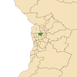 Electoral district of Enfield (green) in the Greater Adelaide area | |||||||||||||||
| State | South Australia | ||||||||||||||
| Dates current | 1956–1970, 2002–present | ||||||||||||||
| MP | John Rau | ||||||||||||||
| Party | Australian Labor Party (SA) | ||||||||||||||
| Namesake | Enfield, South Australia | ||||||||||||||
| Electors | 25,644 (2018) | ||||||||||||||
| Area | 16.48 km2 (6.4 sq mi) | ||||||||||||||
| Demographic | Metropolitan | ||||||||||||||
| Coordinates | 34°51′58″S 138°36′27″E / 34.86611°S 138.60750°ECoordinates: 34°51′58″S 138°36′27″E / 34.86611°S 138.60750°E | ||||||||||||||
| |||||||||||||||
| Footnotes | |||||||||||||||
| Electoral District map[1] | |||||||||||||||
Enfield is a single-member electoral district for the South Australian House of Assembly. Named after the suburb of the same name, it is a 16.48 km2 (6.36 sq mi) suburban electorate in Adelaide's inner north, taking in the suburbs of Blair Athol, Broadview, Clearview, Enfield, Kilburn, Lightsview, Northgate, and Sefton Park; and parts of Nailsworth and Northfield.
Enfield was first created to replace the abolished electoral district of Prospect for the 1956 election.[2] It was abolished for the 1970 election, substantially replaced by the new electorate of Ross Smith.
Enfield was recreated for the 2002 election as a safe Labor electorate, replacing the abolished electorate of Ross Smith, and was won by Labor candidate John Rau. Rau had defeated Ralph Clarke, the former member for Ross Smith, in a Labor preselection ballot. Clarke subsequently contested the election as an independent, but came third, falling 800 votes short of the Liberal candidate. At the 2006 election, Clarke decided to contest a South Australian Legislative Council seat, for which he had very little chance of success. Without competition from Clarke, Rau extended his margin, easily retaining the electorate for Labor.
In the 2016 redistribution by the electoral districts boundaries commission, the districts southern suburbs of Collinswood and Manningham were reassigned to the neighbouring districts of Adelaide and Torrens. The districts western suburbs of Regency Park, Ferryden Park, Angle Park and Mansfield Park were reassigned to the adjacent district of Croydon. The northeastern boundary was extended to include the suburbs of Northgate, Lightsview and part of Northfield within Enfield district, and the southwestern boundary was shifted south slightly to include part of Prospect.
In both of its incarnations, Enfield has been a comfortably-safe Labor seat.
Members for Enfield
| First incarnation 1956–1970 | |||
|---|---|---|---|
| Member | Party | Term | |
| Joe Jennings | Labor | 1956–1970 | |
| Second incarnation 2002– | |||
| Member | Party | Term | |
| John Rau | Labor | 2002–present | |
Election results
| Party | Candidate | Votes | % | ± | |
|---|---|---|---|---|---|
| Labor | John Rau | 8,882 | 40.9 | −5.1 | |
| Liberal | Deepa Mathew | 5,761 | 26.6 | −10.5 | |
| SA-BEST | Carol Martin | 4,004 | 18.5 | +18.5 | |
| Greens | Cassie Alvey | 1,802 | 8.3 | −0.0 | |
| Conservatives | Steve Edmonds | 718 | 3.3 | −2.9 | |
| Dignity | Emma Cresdee | 526 | 2.4 | +2.1 | |
| Total formal votes | 21,693 | 95.5 | −0.7 | ||
| Informal votes | 1,017 | 4.5 | +0.7 | ||
| Turnout | 22,710 | 88.6 | +6.1 | ||
| Two-party-preferred result | |||||
| Labor | John Rau | 12,554 | 57.9 | +2.3 | |
| Liberal | Deepa Mathew | 9,139 | 42.1 | −2.3 | |
| Labor hold | Swing | +2.3 | |||
Notes
- ↑ Electoral District of Enfield (Map). Electoral Commission of South Australia. 2018. Retrieved 1 April 2018.
- ↑ "Statistical Record of the Legislature, 1836 – 2007" (PDF). Parliament of South Australia. Retrieved 20 January 2014.
- ↑ State Election Results – District Results for Enfield, ECSA.